| Parral River | |
|---|---|
 | |
| Location | |
| Country | Mexico |
| Physical characteristics | |
| Mouth | |
• location | Rio Florido |
The Parral River is a river of Mexico. It is a tributary of the Rio Florido, which flows into the Rio Conchos, which in turn flows into the Rio Grande.
| Parral River | |
|---|---|
| | |
| Location | |
| Country | Mexico |
| Physical characteristics | |
| Mouth | |
• location | Rio Florido |
The Parral River is a river of Mexico. It is a tributary of the Rio Florido, which flows into the Rio Conchos, which in turn flows into the Rio Grande.

The Rio Grande in the United States or the Río Bravo in Mexico, also known as P’osoge in Tewa and Tó Ba’áadi in Navajo, is one of the principal rivers in the Southwestern United States and in northern Mexico. The length of the Rio Grande is 1,896 miles (3,051 km), making it the 4th longest river in the United States and in North America by main stem. It originates in south-central Colorado, in the United States, and flows to the Gulf of Mexico. The Rio Grande drainage basin (watershed) has an area of 182,200 square miles (472,000 km2); however, the endorheic basins that are adjacent to and within the greater drainage basin of the Rio Grande increase the total drainage-basin area to 336,000 square miles (870,000 km2).

The Pecos River originates in north-central New Mexico and flows into Texas, emptying into the Rio Grande. Its headwaters are on the eastern slope of the Sangre de Cristo mountain range in Mora County north of Pecos, New Mexico, at an elevation of over 12,000 feet (3,700 m). The river flows for 926 miles (1,490 km) before reaching the Rio Grande near Del Rio. Its drainage basin encompasses about 44,300 square miles (115,000 km2).
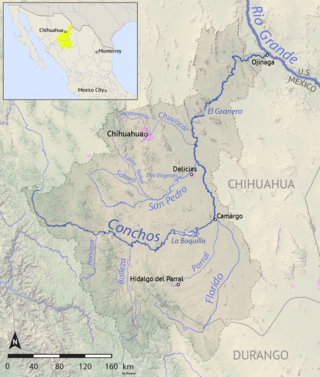
The Río Conchos is a large river in the Mexican state of Chihuahua. It joins the Río Bravo del Norte at the town of Ojinaga, Chihuahua.

The Río Grande de Santiago, or Santiago River, is a river in western Mexico. It flows westwards from Lake Chapala via Ocotlán through the states of Jalisco and Nayarit to empty into the Pacific Ocean. It is one of the longest rivers in Mexico, measuring up 433 km (269 mi) long.
The Rio Chama, a major tributary river of the Rio Grande, is located in the U.S. states of Colorado and New Mexico. The river is about 130 miles (210 km) long altogether. From its source to El Vado Dam its length is about 50 miles (80 km), from El Vado Dam to Abiquiu Dam is about 51 miles (82 km), and from Abiquiu Dam to its confluence with the Rio Grande is about 34 miles (55 km).
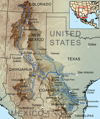
The San Juan River is the largest and most important river in the Mexican state of Nuevo León. The river feeds the El Cuchillo Dam, which provides the city of Monterrey with water. The San Juan River basin has a total surface area of 33,538 square kilometres (12,949 sq mi). The San Juan River is a tributary to the Rio Grande — which is the fourth largest river basin in North America. It begins in Coahuila, flows through Nuevo León and into Tamaulipas, where it finally joins the Rio Grande near Camargo, Tamaulipas.

The Rio Puerco is a tributary of the Rio Grande in the U.S. state of New Mexico. From its source on the west side of the Nacimiento Mountains, it flows about 230 miles (370 km), generally south to join the Rio Grande about 20 miles (32 km) south of Belen and about 50 miles (80 km) south of Albuquerque. Its drainage basin is about 7,350 square miles (19,000 km2) large, of which probably about 1,130 square miles (2,900 km2) are noncontributing.
The Atoyac River is a river in Oaxaca, Mexico. The Atoyac flows into the Rio Verde which empties into the Pacific near Laguna Chacahua, in Lagunas de Chacahua National Park, 90 km west of Puerto Escondido. The mountainous terrain of the region it occupies allows for no navigable rivers; instead, there are a large number of smaller ones, which often change name from area to area. The continental divide passes through the state, meaning that there is drainage towards both the Gulf of Mexico and the Pacific Ocean. Most of the drainage towards the Gulf is represented by the Papaloapan and Coatzacoalcos Rivers and their tributaries such as the Grande and Salado Rivers. Three rivers account for most of the water headed for the Pacific: the Mixteco River, Tehuantepec River, and the Atoyac, with their tributaries.

The Balleza River, or Río Balleza, is a river of Mexico. It is a tributary of the Rio Conchos, which in turn flows into the Rio Grande.
The Candela River is a river of Mexico. It is a tributary of the Rio Salado, which in turn flows into the Rio Grande.

The Chuvíscar River is a river of Mexico. It is a tributary of the Rio Conchos, which in turn flows into the Rio Grande. It flows through the Mexican state of Chihuahua, directly through the state capital, the city of Chihuahua.

The Tehuantepec River is a river in Oaxaca, Mexico. The Tehuantepec flows into the Gulf of Tehuantepec on the Pacific Ocean coast of the Isthmus of Tehuantepec. The mountainous terrain of the region it occupies allows for no navigable rivers; instead, there are a large number of smaller ones, which often change name from area to area. The continental divide passes through the state, meaning there is drainage toward both the Gulf of Mexico and the Pacific. Most of the drainage toward the Gulf is represented by the Papaloapan and Coatzacoalcos rivers and their tributaries such as the Grande and Salado Rivers. Three rivers account for most of the water headed for the Pacific: the Atoyac River, Mixteco River, and the Tehuantepec River, with their tributaries.
The San Pedro River (Chihuahua) is a river of Mexico. It is a tributary of the Rio Conchos, which in turn flows into the Rio Grande.

The Sabinas River is a river in Mexico. It is a tributary of the Rio Salado, which in turn flows into the Rio Grande.
The Sabinas Hidalgo River is a river of Mexico. It is a tributary of the Rio Salado, which in turn flows into the Rio Grande.
The Pesquería River, is a river of Mexico. It is a tributary of the San Juan River, which in turn flows into the Rio Grande.
The Huaynamota River is a river in western Mexico. It is a tributary of the Río Grande de Santiago in the southern Sierra Madre Occidental.
Florido River is a river of Mexico. It is a tributary of the Rio Conchos, which in turn flows into the Rio Grande.

The Jemez River is a tributary of the Rio Grande in eastern Sandoval County, New Mexico, United States.
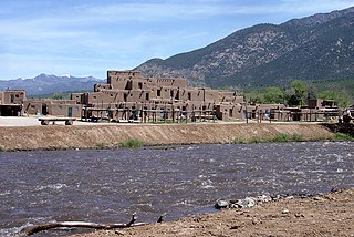
The Rio Pueblo de Taos, also known as Rio Pueblo, is a stream in Taos County, New Mexico, United States, that a tributary of the Rio Grande. From its source in the Sangre de Cristo Mountains it flows about 33 miles (53 km), generally south and west, to join the Rio Grande in the Rio Grande Gorge. On the way the river passes by Taos and through Taos Pueblo.
| | This article related to a river in Mexico is a stub. You can help Wikipedia by expanding it. |