A factory, manufacturing plant or production plant is an industrial facility, often a complex consisting of several buildings filled with machinery, where workers manufacture items or operate machines which process each item into another. They are a critical part of modern economic production, with the majority of the world's goods being created or processed within factories.

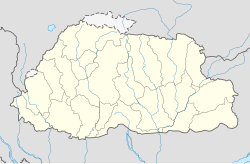
Chukha District is one of the 20 dzongkhag (districts) comprising Bhutan. The major town is Phuentsholing which is the gateway city along the sole road which connects India to western Bhutan. Chukha is the commercial and the financial capital of Bhutan. With Bhutan's oldest hydropower plant, Chukha hydel, and Tala Hydroelectricity Project, the country's largest power plant, Chukha is the dzongkhag which contributes the most to the GDP of the country. Also located in Chukha district are some of the country's oldest industrial companies like the Bhutan Carbide Chemical Limited (BCCL) and the Bhutan Boards Products Limited (BBPL).

Samtse District is one of the 20 dzongkhags (districts) comprising Bhutan. It comprises two subdistricts (dungkhags): Tashicholing and Dophuchen. They are further subdivided into 15 gewogs. The Samtse district covers a total area of 1304 km2.
Tashi, also spelled Trashi, is a Tibetan word meaning "good fortune" or "auspiciousness". Tashi or Trashi may refer to:

Vapi, is a city and Municipal Corporation in Valsad district in the state of Gujarat, India. It is situated near the banks of the Daman Ganga River, around 28 km south of the district headquarters in the city of Valsad, and it is surrounded by the Union Territory of Dadra and Nagar Haveli and Daman and Diu. The town originally belonged to the Kshatriya Jagirdar family Palande during The Great Maratha Empire. After independence from the British Crown, the Jagirdar system was abolished by the Indian government in 1951 and the community of Anavil Brahmin who formerly acted as tax farmers during the era of the Maratha Empire received the land. It is believed that the city got its name from the old small stepwell which was built by Maratha and is situated near the Balitha area.The meaning of vapi (वापी) in sanskrit is a water reservoir or a water storage body.

Mo Chhu is a major river in Bhutan. The word "Chhu" means "river" or "water" in Dzongkha, the official national language in Bhutan. The river rises in Gasa Dzongkhag (district) near the border between Bhutan and Tibet. From there, the Mo Chhu flows generally southward to Punakha in central Bhutan, where it joins the Pho Chhu from the northeast. The confluence of the two streams is immediately below the Punakha Dzong, which is the winter home of the Dratshang Lhentshog and the Je Khenpo. The combined streams are then joined by the Dang Chhu near the town of Wangdue Phodrang, and the name of the river becomes the Puna Tsang Chhu. The river then flows through Dagana and Tsirang Districts. After leaving Bhutan near the town of Lhamoidzingkha, formerly known as Kalikhola, the river enters Assam in India and is known as the Sankosh. The Sankosh ultimately empties into the Brahmaputra, flowing into the Bay of Bengal.

Sankosh is a river that rises in northern Bhutan and empties into the Brahmaputra in the state of Assam in India. In Bhutan, it is known as the Puna Tsang Chu below the confluences of several tributaries near the town of Wangdue Phodrang.

Kurjey Lhakang,སྐུ་རྗེས་ ཡང་ན་ གུ་རུ་རིན་པོ་ཆེ་གི་ ཞབས་རྗེས་ also known as the Kurjey Monastery, is located in the Bumthang valley in the Bumthang district of Bhutan. This is the final resting place of the remains of the first three Kings of Bhutan. Also, a large tree behind one of the temple buildings is believed to be a terma that was left there by Padmasambhava.
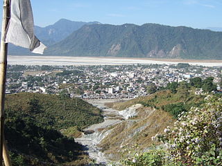
Phuntsholing, also spelled as Phuentsholing, is a border town in southern Bhutan and is the administrative seat of Chukha District. The town occupies parts of both Phuentsholing Gewog and Sampheling Gewog.

Jaigaon is a census town in Alipurduar subdivision under Kalchini Block of Alipurduar district in the state of West Bengal, India. It is located on the country's border with Bhutan, and Bhutan Gate separates the two countries. Phuentsholing is the Bhutan's nearest city to Jaigaon. Bhutan does not have domestic roads linking all its towns, so it uses roads passing through Jaigaon to reach destinations such as Samtse, Gomtu, Nganglam and Samdrup Jongkhar.

Dharapuram is a town situated along the banks of Amaravati River in Tiruppur district in the Indian state of Tamil Nadu. Dharapuram is one of the oldest towns in South India and was the capital of Kongu Nadu under the Cheras, Western Ganga Dynasty and later Kongu Cholas, at which time it was known as Viradapuram. Amaravathi River flows through the town. As of 2011, the town had a population of 67,007. The city houses famous temples including Agatheeswarar Temple, Kaadu Hanumanthasamy temple and many other old temples.

Gasa Dzong༼མགར་ས།༽ or Gasa Tashi Tongmön Dzong near Gasa is the administrative center of Gasa Dzongkhag (district) in the northwestern region of Bhutan. The Dzong was built in the 17th century by Tenzin Drukdra the second Druk Desi over the site of a meditation place established by Drubthob Terkungpa in the 13th century. The Dzong was constructed as a bulwark against attacks from the north and named Tashi Tongmön Dzong. It was later expanded by the fourth Desi, Gyalse Tenzin Rabgye. Inside the Guardian's Temple he placed ritual object and performed the consecration ceremony.
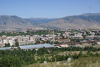
Charentsavan, is a town and urban municipal community in the Kotayk Province of Armenia. It was founded in 1947 as Lusavan, and renamed in 1967 after the poet Yeghishe Charents. According to the 2011 census, the population of Charentsavan is 20,363. As per the 2016 official estimate, Charentsavan has a population of around 18,500. As of the 2022 census, the town had a population of 22,071.

The Hawthorne Works was a large factory complex of the Western Electric Company in Cicero, Illinois. In addition to industrial plants, several on-site community amenities were provided to workers. Named for the original name of what became Cicero, Hawthorne, it opened in 1905 and operated until 1983. At its peak of operations, Hawthorne employed 45,000 workers, producing large quantities of telephone equipment, but also a wide variety of consumer products.
Mining of industrial minerals was insignificant to Bhutan’s economy except for the production of ferrosilicon. The country’s rugged terrain provides sites to harvest hydropower, which has driven rapid growth in the transport and construction sectors, including the startup of a number of local cement operations.

The Raidāk River, also called Wang Chhu or Wong Chhu in Bhutan, is a trans-boundary river originating in Bhutan that is a tributary of the River Brahmaputra. It flows through Bhutan, India and Bangladesh. It is one of the main rivers in Alipurduar District, West Bengal, India.
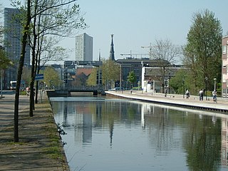
The Eindhovensch Kanaal is a canal in the Dutch province of North Brabant. It connects the center of Eindhoven with the Zuid-Willemsvaart. It was dug in the period 1843-1846, commissioned by the town of Eindhoven. The canal is 13.9 kilometers long and runs by a number of Eindhoven industrial areas and the towns of Geldrop, Mierlo and Helmond. The canal runs over the Kleine Dommel and the Goorloop, which are led under the canal by ducts.

Among Bhutan's most pressing environmental issues are traditional firewood collection, crop and flock protection, and waste disposal, as well as modern concerns such as industrial pollution, wildlife conservation, and climate change that threaten Bhutan's population and biodiversity. Land and water use have also become matters of environmental concern in both rural and urban settings. In addition to these general issues, others such as landfill availability and air and noise pollution are particularly prevalent in relatively urbanized and industrialized areas of Bhutan. In many cases, the least financially and politically empowered find themselves the most affected by environmental issues.

The H. J. Heinz, Wigan factory is a food manufacturing plant owned by H. J. Heinz Company, based in Kitt Green, Orrell, Wigan in Greater Manchester, England. It is one of the largest food processing plants in Europe and the largest H. J. Heinz facility in the world. It produces over one billion cans of food annually and employs around 850 people.
The Tashi Group of Companies is the largest privately owned conglomerate of companies in Bhutan.