Paseo de la Guerra

Last updated

Coordinates: 34°25′12.19″N119°41′59.21″W / 34.4200528°N 119.6997806°W / 34.4200528; -119.6997806

Geographic coordinate system Coordinate system

A geographic coordinate system is a coordinate system that enables every location on Earth to be specified by a set of numbers, letters or symbols. The coordinates are often chosen such that one of the numbers represents a vertical position and two or three of the numbers represent a horizontal position; alternatively, a geographic position may be expressed in a combined three-dimensional Cartesian vector. A common choice of coordinates is latitude, longitude and elevation. To specify a location on a plane requires a map projection.

El Paseo,
in Santa Barbara, California. USA-Santa Barbara-El Paseo-4.jpg
El Paseo,
in Santa Barbara, California.
Casa de la Guerra,
in Santa Barbara, California. USA-Santa Barbara-Casa De la Guerra-1.jpg
Casa de la Guerra,
in Santa Barbara, California.

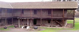
The Paseo de la Guerra is a complex of historic buildings in downtown Santa Barbara, California. Since 1977 it is listed (as El Paseo and Casa de la Guerra) in National Register of Historic Places. [1]

Santa Barbara, California City in California, United States

Santa Barbara is the county seat of Santa Barbara County in the U.S. state of California. Situated on a south-facing section of coastline, the longest such section on the West Coast of the United States, the city lies between the steeply rising Santa Ynez Mountains and the Pacific Ocean. Santa Barbara's climate is often described as Mediterranean, and the city has been promoted as the "American Riviera". As of 2014, the city had an estimated population of 91,196, up from 88,410 in 2010, making it the second most populous city in the county after Santa Maria. The contiguous urban area, which includes the cities of Goleta and Carpinteria, along with the unincorporated regions of Isla Vista, Montecito, Mission Canyon, Hope Ranch, Summerland, and others, has an approximate population of 220,000. The population of the entire county in 2010 was 423,895.

National Register of Historic Places federal list of historic sites in the United States

The National Register of Historic Places (NRHP) is the United States federal government's official list of districts, sites, buildings, structures, and objects deemed worthy of preservation for their historical significance. A property listed in the National Register, or located within a National Register Historic District, may qualify for tax incentives derived from the total value of expenses incurred preserving the property.

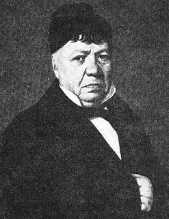
It includes the Spanish Colonial architecture adobe Casa de la Guerra , the restored historic home of a Spanish Military Officer, Civil Servant, and Californio rancher José de la Guerra y Noriega on which construction begun in the 18th century.

Spanish Colonial architecture architectural style

Spanish Colonial architecture represents Spanish colonial influence on New World and East Indies' cities and towns, and it is still being seen in the architecture as well as in the city planning aspects of conserved present-day cities. These two visible aspects of the city are connected and complementary. The 16th century Laws of the Indies included provisions for the layout of new colonial settlements in the Americas and elsewhere.

Adobe Building material made from earth and organic materials

Adobe is a building material made from earth and organic materials. Adobe is Spanish for mudbrick, but in some English-speaking regions of Spanish heritage, the term is used to refer to any kind of earth construction. Most adobe buildings are similar in appearance to cob and rammed earth buildings. Adobe is among the earliest building materials, and is used throughout the world.

Casa de la Guerra place in California listed on National Register of Historic Places

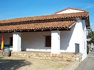
The Casa de la Guerra was the residence of the fifth commandant of the Presidio de Santa Barbara, José de la Guerra y Noriega from 1828 until his death in 1858. Descendants of José lived in the home until 1943. The site is currently owned and operated by the Santa Barbara Trust for Historic Preservation as a historic house museum. The address is 15 East De la Guerra Street, Santa Barbara, California.

Paseo de la Guerra became an artisan and shops arcade integrating the adobe in the mid-20th century, with Spanish Colonial Revival architecture by renowned local architect Lutah Maria Riggs, the associate of George Washington Smith.

Artisan skilled craft worker who makes or creates things by hand

An artisan is a skilled craft worker who makes or creates things by hand that may be functional or strictly decorative, for example furniture, decorative arts, sculptures, clothing, jewellery, food items, household items and tools or even mechanisms such as the handmade clockwork movement of a watchmaker. Artisans practice a craft and may through experience and aptitude reach the expressive levels of an artist.

The Spanish Colonial Revival Style is an architectural stylistic movement arising in the early 20th century based on the Spanish Colonial architecture of the Spanish colonization of the Americas.

Architect person trained to plan and design buildings, and oversee their construction

An architect is a person who plans, designs and reviews the construction of buildings. To practice architecture means to provide services in connection with the design of buildings and the space within the site surrounding the buildings that have human occupancy or use as their principal purpose. Etymologically, architect derives from the Latin architectus, which derives from the Greek, i.e., chief builder.

Paseo de la Guerra continues as a major landmark and attraction, as a museum and boutique mall.

See also

José de la Guerra y Noriega American settler

José Antonio de la Guerra y Noriega was a soldier and early settler of California.

Pablo de la Guerra American politician

Pablo de la Guerra, from the de la Guerra family of Santa Barbara, California, was the Acting Lieutenant Governor of California, 1861-1862. He served in the California State Senate 2nd District. He was a Democrat.

Antonio Maria de la Guerra, Mayor of Santa Barbara, California, several times a member of the Santa Barbara County Board of Supervisors, California State Senator and Captain of California Volunteers in the American Civil War.

Related Research Articles

Los Alamos Ranch House place in California listed on National Register of Historic Places

The Los Alamos Ranch House is a historic adobe house near Los Alamos in northern Santa Barbara County, California. The house, the centerpiece of a Rancho Los Alamos, was built about 1840, and is one of the best-preserved examples of domestic architecture from California's Mexican period. The building was designated a National Historic Landmark in 1970.

Presidio of Santa Barbara place in California listed on National Register of Historic Places

El Presidio Real de Santa Bárbara, also known as the Royal Presidio of Santa Barbara, is a former military installation in Santa Barbara, California, USA. The presidio was built by Spain in 1782, with the mission of defending the Second Military District in California. In modern times, the Presidio serves as a significant tourist attraction, museum and an active archaeological site as part of El Presidio de Santa Barbara State Historic Park.

De La Guerra Plaza is a small park type area in downtown Santa Barbara, California, USA, located right next to the Santa Barbara News-Press offices. It is best known for the activities that take place there during Santa Barbara's annual Fiesta in early August. There are booths, musical performances and lots of festivities for the downtown area in De La Guerra Plaza. In the 1950s, there was a glass blowing booth where children could buy and take home glass ornaments as souvenirs.

Monterey Colonial architecture

Monterey Colonial is an architectural style developed in Alta California. The style is characterized by two stories, continuous surrounding porches on both levels, a hip roof, and adobe walls. The first known example of the style was the Alpheus Thompson house in Santa Barbara, California, built in 1834 and demolished in 1913. The second example is the Larkin House in Monterey, California, built by Thomas O. Larkin in 1835. The largest example of the style is the Rancho Petaluma Adobe, begun by Mariano Vallejo in Petaluma, California in 1836.

Rancho Los Alamos was a 48,803-acre (197.50 km2) Mexican land grant in present-day Santa Barbara County, California given in 1839 by Governor Juan Alvarado to José Antonio de la Guerra, a son of José de la Guerra y Noriega. Los Alamos is Spanish for "the cottonwoods" and describes Fremont Cottonwood (Populus fremontii) trees lining the banks of the San Antonio Creek.

Guerra may refer to:

Rancho El Conejo was a 48,572-acre (196.56 km2) Spanish land grant in California given in 1803 to Jose Polanco and Ygnacio Rodriguez that encompassed the area now known as the Conejo Valley in southeastern Ventura and northwestern Los Angeles Counties. El Conejo means "The Rabbit" in Spanish, and refers to the many rabbits common to the region. The east-west grant boundaries approximately went from the border of Westlake Village near Lindero Canyon Road in the east to the Conejo Grade in the west. The north-south borders extended from the top of the Simi Hills at the end of Moorpark Road in the north to Hidden Valley in the Santa Monica Mountains in the south. The rancho is the site of the communities of Newbury Park, Thousand Oaks, and Westlake Village.

Rancho San Julian was a 48,222-acre (195.15 km2) Mexican land grant and present-day ranch in present-day Santa Barbara County, California given in 1837 by Governor Juan B. Alvarado to José de la Guerra y Noriega. The grant name probably refers to José Antonio Julian de la Guerra. The grant was located west of present-day Santa Barbara.

Rancho Punta de la Concepcion was a 24,992-acre (101.14 km2) Mexican land grant in the northern Santa Ynez Mountains, in present day Santa Barbara County, California. It was granted by Governor Juan Alvarado in 1837, to Anastacio Carrillo. The grant extended along the Pacific coast from Point Arguello south to Cojo Creek, just east of Point Conception.

Rancho Las Posas was a 26,623-acre (107.74 km2) Mexican land grant in present-day Ventura County, California. It was given in 1834 by Governor José Figueroa to José Antonio Carrillo.

Rancho Todos Santos y San Antonio was a 20,772-acre (84.06 km2) Mexican land grant in present-day Santa Barbara County, California given in 1841 by Governor Juan B. Alvarado to William Edward Petty Hartnell. The grant extended along San Antonio Creek and encompassed present-day Orcutt., northwest of Lompoc

Rancho Cuyama was a 48,827-acre (197.60 km2) Mexican land grant in present day eastern Santa Barbara County, California given in 1846 by Governor Pío Pico to Cesario Lataillade. The grant extended along Cuyama River in the Cuyama Valley, near Cuyama and New Cuyama. There were two Mexican land grants made in the lower Cuyama Valley: on the north Rancho Cuyama granted in 1843 and to the south Rancho Cuyama granted in 1846.

Rancho Cuyama was a 22,193-acre (89.81 km2) Mexican land grant in present-day eastern Santa Barbara County, California given in 1843 by Governor Manuel Micheltorena to José María Rojo. The grant extended along Cuyama River in the Cuyama Valley, near Cuyama and New Cuyama. There were two Mexican land grants made in the lower Cuyama Valley: on the north Rancho Cuyama granted in 1843, and to the south Rancho Cuyama granted in 1846.

Rancho La Zaca was a 4,458-acre (18.04 km2) Mexican land grant in present-day central Santa Barbara County, California given in 1838 by Governor Juan B. Alvarado to Antonio, an Indian. The grant was located along Zaca Creek, north of Rancho Corral de Cuati and surrounded by Rancho La Laguna, east of the Santa Ynez Valley.

Rancho Corral de Cuati was a 13,322-acre (53.91 km2) Mexican land grant in present-day Santa Barbara County, California given in 1845 by Governor Pío Pico to Agustín Dávila. The grant was located along Alamo Pintado Creek, north of present-day Los Olivos. The grant is surrounded by Rancho La Laguna.

Angustias de la Guerra Ord American historian

María de las Angustias de la Guerra Ord was an American historian of Hispanic descent. Her memoirs describe California's transition from Spanish-Mexican territory to American state.

References