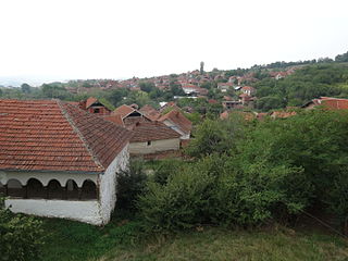
Paskašija | |
---|---|
Village | |
Country | |
District | Pirot District |
Municipality | Dimitrovgrad |
Population (2002) | |
• Total | 11 |
Time zone | CET (UTC+1) |
• Summer (DST) | CEST (UTC+2) |
Paskašija is a village in the municipality of Dimitrovgrad, Serbia. According to the 2002 census, the village has a population of 11 people. [1]
A village is a clustered human settlement or community, larger than a hamlet but smaller than a town, with a population ranging from a few hundred to a few thousand. Though villages are often located in rural areas, the term urban village is also applied to certain urban neighborhoods. Villages are normally permanent, with fixed dwellings; however, transient villages can occur. Further, the dwellings of a village are fairly close to one another, not scattered broadly over the landscape, as a dispersed settlement.
Dimitrovgrad is a town and municipality located in the Pirot District of southeastern Serbia. According to 2011 census, the municipality of Dimitrovgrad has a population of 10,118 people and the town 6,278.
Serbia, officially the Republic of Serbia, is a country situated at the crossroads of Central and Southeast Europe in the southern Pannonian Plain and the central Balkans. The sovereign state borders Hungary to the north, Romania to the northeast, Bulgaria to the southeast, North Macedonia to the south, Croatia and Bosnia and Herzegovina to the west, and Montenegro to the southwest. The country claims a border with Albania through the disputed territory of Kosovo. Serbia's population is about seven million, most of whom are Orthodox Christians. Its capital, Belgrade, ranks among the oldest and largest citiеs in southeastern Europe.
The Bystrytsia is a river, a right tributary of the Dniester which flows through Tysmenytsia Raion, Ivano-Frankivsk Oblast.
University Club Tower is a condominium tower in Milwaukee, Wisconsin. At 446 feet, it is the fourth tallest building in Wisconsin and the tallest residential building. It is located in Milwaukee's East Town neighborhood adjacent to the Lake Michigan shoreline.
Maleszów is a village in the administrative district of Gmina Kondratowice, within Strzelin County, Lower Silesian Voivodeship, in south-western Poland. Prior to 1945 it was in Germany.
Białobłota is a village in the administrative district of Gmina Szypliszki, within Suwałki County, Podlaskie Voivodeship, in north-eastern Poland, close to the border with Lithuania.
Beysug is a river in Krasnodar Krai of Russia. It is 243 kilometres (151 mi) long, with a drainage basin of 5,190 square kilometres (2,000 sq mi). It flows into the Azov Sea through the Beysugsky Liman. To the south is the Kuban River, to the immediate north the Chelbas River, and further to the north the Yeya River.
Thurstable School is a mixed secondary academy school, sports college and sixth form situated in the village of Tiptree, Essex. The school is located about 8 miles from Colchester.
Lejdy is a village in the administrative district of Gmina Bartoszyce, within Bartoszyce County, Warmian-Masurian Voivodeship, in northern Poland, close to the border with the Kaliningrad Oblast of Russia. It lies approximately 10 kilometres (6 mi) north of Bartoszyce and 64 km (40 mi) north of the regional capital Olsztyn.
Lauciene parish is an administrative unit of the Talsi District, Latvia.
Serra Alta is a municipality in the state of Santa Catarina in the South region of Brazil.
Donja Kupinovica is a village in the municipality of Leskovac, Serbia. According to the 2002 census, the village has a population of 97 people.
Drćevac is a village in the municipality of Leskovac, Serbia. According to the 2002 census, the village has a population of 309 people.
Golema Njiva is a village in the municipality of Leskovac, Serbia. According to the 2002 census, the village has a population of 118 people.
Gornja Kupinovica is a village in the municipality of Leskovac, Serbia. According to the 2002 census, the village has a population of 189 people.
Jarsenovo is a village in the municipality of Leskovac, Serbia. According to the 2002 census, the village has a population of 428 people.
Oraovica is a village in the municipality of Leskovac, Serbia. According to the 2002 census, the village has a population of 152 people.
Orašac is a village in the municipality of Leskovac, Serbia. According to the 2002 census, the village has a population of 582 people.
Rajno Polje is a village in the municipality of Leskovac, Serbia. According to the 2002 census, the village has a population of 739 people.
Sarıbuğday is a village in the District of Merzifon, Amasya Province, Turkey.
Çandır, Serik is a township in the District of Serik, Antalya Province, Turkey.
Grant Township is a township in O'Brien County, Iowa, USA.
Coordinates: 43°02′32″N22°44′53″E / 43.0422°N 22.7481°E
A geographic coordinate system is a coordinate system that enables every location on Earth to be specified by a set of numbers, letters or symbols. The coordinates are often chosen such that one of the numbers represents a vertical position and two or three of the numbers represent a horizontal position; alternatively, a geographic position may be expressed in a combined three-dimensional Cartesian vector. A common choice of coordinates is latitude, longitude and elevation. To specify a location on a plane requires a map projection.
This Pirot District, Serbia location article is a stub. You can help Wikipedia by expanding it. |