Related Research Articles

Harold Wood is a suburban neighbourhood in East London in the London Borough of Havering. It is situated 16.5 miles (26.6 km) east-northeast of Charing Cross. Harold Wood was part of the ancient parish of Hornchurch, which became the Liberty of Havering. Most of the current area of Harold Wood became part of Hornchurch Urban District in 1926. It is near to the Greater London boundary with Essex.

Hornchurch is a suburban town in East London in the London Borough of Havering. It is located 15.2 miles (24.5 km) east-northeast of Charing Cross. It comprises a number of shopping streets and a large residential area. It historically formed a large ancient parish in the county of Essex that became the manor and liberty of Havering. The economic history of Hornchurch is underpinned by a shift away from agriculture to other industries with the growing significance of nearby Romford as a market town and centre of administration. As part of the suburban growth of London in the 20th century, Hornchurch significantly expanded and increased in population, becoming an urban district in 1926 and has formed part of Greater London since 1965. It is the location of Queen's Theatre, Havering Sixth Form College and Havering College of Further and Higher Education.

The London Borough of Havering in East London, England, forms part of Outer London. It has a population of 259,552 inhabitants; the principal town is Romford, while other communities are Hornchurch, Upminster, Collier Row and Rainham. The borough is mainly suburban, with large areas of protected open space. Romford is a major retail and night time entertainment centre, and to the south the borough extends into the London Riverside redevelopment area of the Thames Gateway. The name Havering is a reference to the Royal Liberty of Havering which occupied the area for several centuries. The local authority is Havering London Borough Council. It is the easternmost London borough.

Upminster is an interchange station serving the town of Upminster in the London Borough of Havering, Greater London. It is on the London, Tilbury and Southend line (LTSR), 15 miles 20 chains (24.5 km) down the line from London Fenchurch Street; it is the eastern terminus of the District line on the London Underground; and it is the eastern terminus of the Romford to Upminster Line on the London Overground network. Upminster is the easternmost station on the London Underground network as well as the easternmost National Rail station in London.

Upminster Bridge is a crossing of the River Ingrebourne carrying the A124 road between the suburbs of Hornchurch and Upminster in northeast London, England. The bridge is known to have existed since at least 1375 and the current brick bridge was opened in 1892, replacing a series of wooden bridges. It gave its name to the nearby Upminster Bridge tube station, which opened in 1934, and has also been applied to the neighbourhood around the station in the London Borough of Havering.

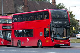
London Buses route 5 is a Transport for London contracted bus route in London, England. Running between Romford Market and Canning Town bus station, it is operated by Blue Triangle.

Addiscombe tram stop is a light rail stop in the London Borough of Croydon in the southern suburbs of London.

The A118 is a road in east London, England which links Bow Interchange with Gallows Corner in Romford via Stratford and Ilford.
Rush Green Hospital was a hospital located at Rush Green in the London Borough of Barking and Dagenham in London from 1900 to 1995.
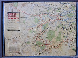
London United Tramways Company Limited was an operator of trams and trolleybuses in the western and southern suburbs of London, UK, from 1894 to 1933, when it passed to the London Passenger Transport Board.
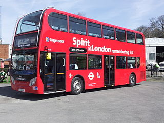
East London Bus & Coach Company Limited, trading as Stagecoach London, is a bus company operating in East London. The East London brand is a subsidiary of Stagecoach London and operates services under contract to Transport for London. Branding was changed from East London to Stagecoach in 2010. The company operates eight depots.
Chase Cross is a district of the London Borough of Havering in London, England. Chase Cross lies 0.8 miles (1.3 km) east of Collier Row, 15 miles (24 km) northeast of Charing Cross and just under 2 miles (3.2 km) north of Romford. The name is thought to come from its position as a crossroads in the chase or Hainault Forest. The forest was cleared for agriculture in the 1850s, before being developed for housing in the 1930s.
East London Bus & Coach Company Limited, trading as Stagecoach London, is a bus company operating in East London. The Thameside brand is a subsidiary of Stagecoach London and operates services under contract to Transport for London. The Thameside brand is not publicly used since 2010 as all buses are branded as Stagecoach, but it exists as a legal entity.
Dalston bus garage was a bus depot in Dalston, London, England.

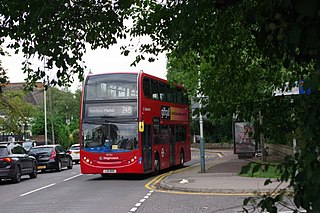
London Buses route 252 is a Transport for London contracted bus route in London, England. Running between Collier Row and Hornchurch, it is operated by Stagecoach London.
Public transport in the London Borough of Havering, in east London, England, is a mix of National Rail, London Underground, London Overground and Elizabeth line and London Buses services. Rail services are primarily radial to central London with bus services providing most of the orbital connections. The public transport authority is Transport for London and the local authority is Havering London Borough Council.

The Brewery is a shopping and leisure centre in Romford town centre, in the London Borough of Havering, England. It is located on the site of the former Star Brewery, and it opened in 2001. It is—along with The Liberty and The Mercury—one of the three main shopping centres in Romford.

London Bridge bus station serves the London Bridge area of the city of London and is situated at the London Bridge tube and rail station.
References
- ↑ "New bus route linking Romford and Havering-atte-Bower | Transport for London". www.tfl.gov.uk. Archived from the original on 1 October 2011.
51°39′19″N0°10′20″E / 51.6552°N 0.1722°E
| | This Essex location article is a stub. You can help Wikipedia by expanding it. |