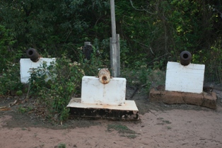
Paterson (Cape York) Telegraph Station

Last updated

Paterson (Cape York) Telegraph Station
Australia Queensland location map.svg
Red pog.svg
Location of Paterson (Cape York) Telegraph Station in Queensland
Australia location map.svg
Red pog.svg
Paterson (Cape York) Telegraph Station (Australia)
LocationPeak Point, Punsad Bay, Cape York Peninsula, Queensland, Australia
Coordinates 10°42′26″S142°30′42″E / 10.707186°S 142.511628°E / -10.707186; 142.511628

The Paterson Telegraph Station (later known as The Cape York Telegraph Station) was a telegraph station in Queensland, Australia. It was the original location for the end of the Cape York Telegraph Line. It was the landing point for the undersea cable Telegraph Cable between Cape York Peninsula and Thursday Island.

Contents

History

The Staff of the Telegraph Station. 1917. 1917 - Nov 17 - The Staff at the Cape York Telegraph Station - Page 23 of the Queenslander Pictorial supplement to The Queenslander 17 November 1917 (2).jpg
The Staff of the Telegraph Station. 1917.

The telegraph station was named after the Postmaster-General, the Hon. Thomas Macdonald-Paterson and was originally located in the area of the Paterson Creek Mouth (the original ruins can still be seen).

The building was completed before the beginning of the wet season in November 1886 and was opened on 25 August 1887.

In 1894 the station was relocated from Peak Point to the north eastern end of Punsand Bay near Bay Point on the West Coast of Cape York, approximately two miles from the north-most point on the Australian continent.

The Cape York Telegraph Line Connection

To the South: McDonnell Telegraph Station

The next station to the south of Paterson was the McDonnell Telegraph Station and was completed before work stopped for the wet season in November 1886. [1]

McDonnell was named [1] after John McDonnell, Under Secretary and Superintendent of Telegraphs of the Post and Telegraph Department. The same John McDonnell was also an uncle of J . R . Bradford .

To the North: Undersea cable to Thursday Island

The undersea armoured cable that connected Patterson to Thursday Island consisted of 18 sea miles of underwater cable was laid by the Cable Ship Recorder and crossed Horn Island. The line formed part of the Cape York Telegraph Line. [1] [2] The laying work was completed in November 1886. [1]

Station transferred

The Telegraph Station at Cape York as Published in The Queenslander, 17 November 1917. 1917 Nov 17 - Cape York Telegraph Station - Page 23 of the Queenslander Pictorial supplement to The Queenslander 17 November 1917 (2).jpg
The Telegraph Station at Cape York as Published in The Queenslander, 17 November 1917.

In 1894 the station was relocated from Peak Point to Punsand Bay on the West Coast of Cape York, approximately two miles from the North most point on the Australian Continent. [3] It is not known why the station was transferred and it is inherent that the Telegraph Line and undersea cable were also relocated as part of this process. It is fact that it was relocated, as ruins exist at both locations, but no references to support the reason have been located.

At Punsand Bay, the station was built high up on a Sandy Plateau overlooking the sea. The tip of Cape York was clearly visible to the North East, with lovely sandy beaches drawing the eye to the tip and Peak Point was visible to the South West. Many Islands were in the view, often crisscrossed with ships as they made their way to and from Thursday Island. A large area was kept clear of vegetation and brush to help prevent Bush Fires and provide a clear view of any approaching people. The soil was bleached White and any visitors were warned of the many Death Adders which were as white as the sandy soil. [4]

Hector Macquarrie from New Zealand visited the station in October/November 1928 in a Baby Austin with his co-driver Dick Matthews at the end of the first ever motor vehicle drive to the tip of Cape York. [5]

Receiving mail

The mail launch travelled to the station every fortnight from Thursday Island. This was known locally as "Mail Day" and served as a gathering for all the locals who would arrive at the Telegraph Station to await the boat and catch up on all the local news. Mr. Tom Dunwoodle and Torrie Woodhead manned the mail boat for some years and were known for arriving with large, freshly caught fish to share with the people waiting for their mail.

Postmasters and their families who ran the station

Known families who ran the station were:[ citation needed ]

Station closure

The station was closed on 14 September 1960. Sadly, all that remains of the station now is a concrete slab and some frangipani trees taken as cuttings from the Lockerbie Station. [4]

Retracing the 1883 telegraph route to the station

In 1973,the Cape York Historical Expedition 1973 [7] was led by Mr. Malcolm M. Rea. The party consisted of seven men on horseback and followed the 1883 Telegraph Route.

Related Research Articles

<i>Challenger</i> expedition Oceanographic research expedition (1872–1876)

The Challenger expedition of 1872–1876 was a scientific programme that made many discoveries to lay the foundation of oceanography. The expedition was named after the naval vessel that undertook the trip, HMS Challenger.

<span class="mw-page-title-main">Cape York Peninsula</span> Peninsula in Far North Queensland, Australia

Cape York Peninsula is a peninsula located in Far North Queensland, Australia. It is the largest wilderness in northern Australia. The land is mostly flat and about half of the area is used for grazing cattle. The relatively undisturbed eucalyptus-wooded savannahs, tropical rainforests and other types of habitat are now recognised and preserved for their global environmental significance. Although much of the peninsula remains pristine, with a diverse repertoire of endemic flora and fauna, some of its wildlife may be threatened by industry and overgrazing as well as introduced species and weeds.

<span class="mw-page-title-main">Moreton Island</span> Island off the Queensland coast, Australia

Moreton Island (Mulgumpin) is an island on the eastern side of Moreton Bay on the coast of South East Queensland, Australia. The Coral Sea lies on the east coast of the island. Moreton Island lies 58 kilometres (36 mi) northeast of the Queensland capital, Brisbane. 98% of the island is contained within a national park and a popular destination for day trippers, four wheel driving, camping, recreational angling and whale watching and a 75-minute ferry ride from Brisbane. It is the third largest sand island in the world. Together with Fraser Island, Moreton Island forms the largest sand structure in the world. It was the traditional country of the Ngugi before settlement.

<span class="mw-page-title-main">Thursday Island</span> Town in Queensland, Australia

Thursday Island, colloquially known as TI, or in the Kawrareg dialect, Waiben or Waibene, is an island of the Torres Strait Islands, an archipelago of at least 274 small islands in the Torres Strait. TI is located approximately 39 kilometres north of Cape York Peninsula in Far North Queensland, Australia. Thursday Island is also the name of the town in the south and west of the island and also the name of the locality which contains the island within the Shire of Torres. The town of Rose Hill is located on the north-eastern tip of the island.

<span class="mw-page-title-main">Cape Moreton</span> Point in Australia

Cape Moreton is a rocky headland at the north eastern tip of Moreton Island in South East Queensland, Australia. The surrounding area is part of the Moreton Island National Park. Flinders Reef is 5 kilometres (3 mi) north-west of Cape Moreton.

<span class="mw-page-title-main">Australian Overland Telegraph Line</span> Major Darwin-Port Augusta telecom link

The Australian Overland Telegraph Line was a telegraphy system to send messages over long distances using cables and electric signals. It spanned 3200 kilometres between Darwin, in what is now the Northern Territory of Australia, and Adelaide, the capital of South Australia. Completed in 1872, it allowed fast communication between Australia and the rest of the world. When it was linked to the Java-to-Darwin submarine telegraph cable several months later, the communication time with Europe dropped from months to hours; Australia was no longer so isolated from the rest of the world. The line was one of the great engineering feats of 19th-century Australia and probably the most significant milestone in the history of telegraphy in Australia.
<span class="mw-page-title-main">Cape Scott Provincial Park</span> Provincial park

Cape Scott Provincial Park extends from Shushartie in the east, then westward around Cape Scott and south to San Josef Bay. This coastline comprises the northern tip of Vancouver Island, British Columbia. The 22,294-hectare (55,090-acre) provincial park is about 563 km (350 mi) northwest of Victoria.

<span class="mw-page-title-main">Somerset, Queensland</span> Suburb of Shire of Torres, Queensland, Australia

Somerset is a coastal locality split between the Shire of Torres and the Northern Peninsula Area Region, Queensland, Australia. In the 2016 census, Somerset had a population of 0 people.

<span class="mw-page-title-main">Prince of Wales Island (Queensland)</span> Island in Queensland, Australia

The Prince of Wales Island, or Muralag, is an island of the Torres Strait Islands archipelago at the tip of Cape York Peninsula within the Endeavour Strait of Torres Strait in Queensland, Australia. The island is situated approximately 20 km (12 mi) north of Muttee Heads which is adjacent to Bamaga and south of Thursday Island. It is within the locality of Prince Of Wales within the Shire of Torres. In the 2016 census, the locality had a population of 109 people.

<span class="mw-page-title-main">Francis Lascelles Jardine</span> Scottish-Australian pioneer

Francis Lascelles (Frank) Jardine was a Scottish-Australian pioneer who was at the forefront of British colonisation and Aboriginal dispossession in the Cape York Peninsula and Torres Strait regions of Far North Queensland.

<span class="mw-page-title-main">Macleay Island</span> Town in Queensland, Australia

Macleay Island is an island in Moreton Bay, South East Queensland, Australia. The island constitutes a town and locality within the City of Redland. In the 2016 census, the locality of Macleay Island had a population of 2,681 people.

<span class="mw-page-title-main">History of telegraphy in Australia</span> Aspect of history

Australia was a relatively early adopter of electrical telegraph technology in the middle of the nineteenth century, despite its low population densities and the difficult conditions sometimes encountered in laying lines. From 1858 onwards, the major capitals were progressively linked, culminating in the addition of Perth in 1877. Australia was linked to the rest of the world for the first time in 1872, through the Overland Telegraph which ran some 3,200 kilometres (2,000 mi) from Adelaide through to Darwin. The network continued to expand in size and sophistication until 1959 and in heavy usage until 1945, after which time telephone usage began to erode public patronage of telegraphy services. The final publicly provided telegraphy service was closed in 1993.

<span class="mw-page-title-main">Ferguslie Peninsula</span> Peninsula of Antarctica

Ferguslie Peninsula is a peninsula 2.4 km (1.5 mi) long, lying between Browns Bay and Macdougal Bay on the north coast of Laurie Island, in the South Orkney Islands of Antarctica. The peninsula was charted in 1903 by the Scottish National Antarctic Expedition under William Speirs Bruce, who named it for Ferguslie, the residence of James Coats, chief patron of the expedition.
<span class="mw-page-title-main">Colony of Queensland</span> British crown colony (1859–1901)

The Colony of Queensland was a colony of the British Empire from 1859 to 1901, when it became a State in the federal Commonwealth of Australia on 1 January 1901. At its greatest extent, the colony included the present-day State of Queensland, the Territory of Papua and the Coral Sea Islands Territory.

<span class="mw-page-title-main">Woody Island Lighthouses</span> Historic site in Queensland, Australia

The Woody Island Lighthouses are a pair of heritage-listed lighthouses at Big Woody Island in the Great Sandy Strait, Hervey Bay, Fraser Coast Region, Queensland, Australia. They were built from 1866 to 1870. It was added to the Queensland Heritage Register on 30 March 2001.

<span class="mw-page-title-main">Musgrave Telegraph Station</span> Historic site in Queensland, Australia

Musgrave Telegraph Station is a heritage-listed former telegraph station and now roadhouse at Peninsula Developmental Road, Musgrave, Yarraden, Shire of Cook, Queensland, Australia. It is also known as Musgrave Roadhouse. It was added to the Queensland Heritage Register on 21 August 1992.

The Cape York Telegraph Line was a telegraph line built on the Cape York Peninsula, Queensland, Australia. It was completed in 1887 and stretched from Laura to Thursday Island.

The Lotiga, also known as the Okara, were an indigenous Australian people of the Cape York Peninsula of North Queensland.

The New Guinea Exploration Expedition of 1885 was a scientific, collecting and anthropological expedition sent by the Geographical Society of Australasia to the Fly River region of Papua New Guinea. The expedition lasted for six months from 10th June to 3rd December 1885, of which five months were spent in New Guinea. They named and explored the Strickland River, and made vast biological discoveries, including numerous species.

<span class="mw-page-title-main">Somerset Graves Site</span> Historic site in Queensland, Australia

Somerset Graves Site is a heritage-listed cemetery at Somerset, Northern Peninsula Area Region, Queensland, Australia. It is also known as Somerset Jardine Cemetery. It was added to the Queensland Heritage Register on 25 January 2018.

References

  1. 1 2 3 4 "John Richard Bradford's Expedition into the Cape". Archived from the original on 7 February 2017. Retrieved 17 February 2017.
  2. "Qld - Cape York lines". telegramsaustralia.com. Archived from the original on 7 February 2017. Retrieved 7 February 2017.
  3. Pearce, Howard (30 June 2014). "Cape York Telegraph Station". Queensland World War 2 Places. Qld Government.
  4. 1 2 "Recollections of the Telegraph Station". Archived from the original on 13 April 2020. Retrieved 13 April 2020.
  5. Gunn, Audrey (2 January 1991). Oral history interview conducted by Anna Shnukal and Adrian Cunningham. West Ryde, NSW: National Library of Australia.
  6. Macquarrie, Hector (1929). We and the Baby. Sydney: Angus. p. 280.
  7. Malcolm M. Rea (18 August 1974). "Cape York Historical Expedition 1973" (PDF). Journal of the Royal Historical Society of Queensland. Archived (PDF) from the original on 22 December 2020. Retrieved 16 February 2017.