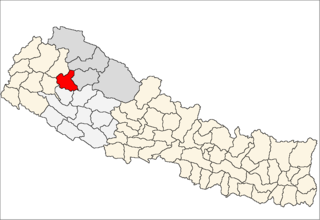
Kalikot District (Nepali: कालीकोट जिल्लाListen , a part of Karnali province, is one of the seventy-seven districts of Nepal. The district, with Manma as its district headquarters, covers an area of 1,741 km², had a population of 105,580 in 2001 and 136,948 in 2011. In September 2005, in a bid to encourage a change in social attitudes, the government announced that it would provide rice to any family that had recently had a girl born.
Chhinamukh is a village development committee in Bhojpur District in the Kosi Zone of eastern Nepal. At the time of the 1991 Nepal census it had a population of 3375 persons living in 639 individual households.
Dhodalekhani is a village development committee in Bhojpur District in the Kosi Zone of eastern Nepal. At the time of the 1991 Nepal census it had a population of 2412 persons living in 455 individual households.

Gupteshwar is a village development committee in Bhojpur District in the Kosi Zone of eastern Nepal. At the time of the 1991 Nepal census it had a population of 2232 persons living in 418 individual households.
Jarayotar is a Village Development Committee in Bhojpur District in the Kosi Zone of eastern Nepal. At the time of the 2011 Nepal census it had a population of 4031 persons residing in 721 individual households. According to ancestors, this place had a large forest with many animals among which antelope were abundant and the land was dug by them to form a plain land. So, the name of the village was kept Jarayotar.
Khairang is a Village Development Committee in Bhojpur District in the Kosi Zone of eastern Nepal. At the time of the 1991 Nepal census it had a population of 3050 persons residing in 533 individual households.
Kudak Kaule is a village development committee in Bhojpur District in the Kosi Zone of eastern Nepal. At the time of the 1991 Nepal census it had a population of 2734 persons living in 507 individual households.

Kulung is a village development committee in Bhojpur District in the Kosi Zone of eastern Nepal. At the time of the 1991 Nepal census it had a population of 4095 persons living in 746 individual households. The postal code of Kulung bhojpur is 57001. The Kulung are one of the indigenous communities of Nepal, as well as parts of northeastern Sikkim and Darjeeling district of India, having their own Kulung language, culture, history and tradition. This name comes after their majority there but nowadays there is mixed locality.

Okhre is a village development committee in Bhojpur District in the Kosi Zone of eastern Nepal. At the time of the 1991 Nepal census it had a population of 2729 persons living in 534 individual households. Here lies a calcium ore.
Sano Dumba is a village development committee in Bhojpur District in the Kosi Zone of eastern Nepal. At the time of the 1991 Nepal census it had a population of 2761 persons living in 501 individual households.
Syamsila is a village development committee in Bhojpur District in the Kosi Zone of eastern Nepal. At the time of the 1991 Nepal census it had a population of 2767 persons living in 517 individual households.
Taksar is a Market in Bhojpur Municipality in Bhojpur District in the Kosi Zone of eastern Nepal. At the time of the 1991 Nepal census it had a population of 4524 persons residing in 829 individual households.

Thidingkha is a village development committee in Bhojpur District in the Kosi Zone of eastern Nepal. At the time of the 1991 Nepal census it had a population of 2293.
Thulo Dumba is a village development committee in Bhojpur District in the Kosi Zone of eastern Nepal. At the time of the 1991 Nepal census it had a population of 2604 persons living in 537 individual households.
Tiwari Bhanjyang is a village development committee in Bhojpur District in the Kosi Zone of eastern Nepal. At the time of the 1991 Nepal census it had a population of 3004 persons living in 534 individual households. The mayor of this VDC is Manit Nidhi Tiwari.
Tunggochha is a village development committee in Bhojpur District in the Kosi Zone of eastern Nepal. At the time of the 1991 Nepal census it had a population of 2446 persons living in 421 individual households.
Laxmipur is a former town and Village Development Committee in Ilam District in the Mechi Zone of eastern Nepal.
Panchakanya is a village development committee in Sunsari District in the Kosi Zone of south-eastern Nepal. At the time of the 1991 Nepal census it had a population of 9422 people living in 1803 individual households.

Sundar Haraicha is a municipality in Morang District of Province No. 1 in Nepal that was established on 10 March 2017 by merging the former municipalities Sundar Dulari and Koshi Haraicha. At the time of the 2011 Nepal census, the localities out of which Chaudandigadhi would be formed had a joint population of 80,518 people living in 18,610 individual households.


