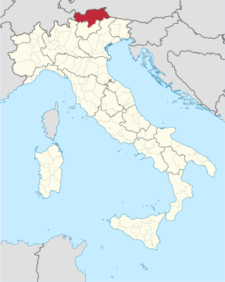
South Tyrol is an autonomous province in northern Italy. An English translation of the official German and Italian names could be the Autonomous Province of Bolzano – South Tyrol, reflecting the multilingualism and different naming conventions in the area. Together with the autonomous province of Trento, South Tyrol forms the autonomous region of Trentino-Alto Adige/Südtirol. The province is the northernmost of Italy, the second largest with an area of 7,400 square kilometres (2,857 sq mi), and has a total population of about 534,000 inhabitants as of 2021. Its capital and largest city is Bolzano.

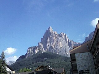
The Schlern is a mountain of the Dolomites in South Tyrol, Italy. The peak at the north west end of the mountain was first ascended in July 1880 by Johann Santner. It is named the Santner Spitze in his honour.

The Karwendel is the largest mountain range of the Northern Limestone Alps. It is located on the Austria–Germany border. The major part belongs to the Austrian federal state of Tyrol, while the adjacent area in the north is part of Bavaria, Germany. Four chains stretch from west to east; in addition, there are a number of fringe ranges and an extensive promontory (Vorkarwendel) in the north.

The High Tauern are a mountain range on the main chain of the Central Eastern Alps, comprising the highest peaks east of the Brenner Pass. The crest forms the southern border of the Austrian states of Salzburg, Carinthia and East Tyrol, with a small part in the southwest belongs to the Italian province of South Tyrol. The range includes Austria's highest mountain, the Grossglockner at 3,798 metres (12,461 ft) above the Adriatic.

Seefeld in Tirol is an old farming village, now a major tourist resort, in Innsbruck-Land District in the Austrian state of Tyrol with a local population of 3,312. The village is located about 17 km (11 mi) northwest of Innsbruck on a plateau between the Wetterstein mountains and the Karwendel on a historic road from Mittenwald to Innsbruck that has been important since the Middle Ages. It was first mentioned in 1022 and since the 14th century has been a pilgrimage site, benefiting not only from the visit of numerous pilgrims but also from its stacking rights as a trading station between Augsburg and the Venice. Also since the 14th century, Tyrolean shale oil has been extracted in the area. Seefeld was a popular holiday resort even before 1900 and, since the 1930s, has been a well known winter sports centres and amongst the most popular tourist resorts in Austria. The municipality, which has been the venue for several Winter Olympics Games, is the home village of Anton Seelos, the inventor of the parallel turn.
Barmer may refer to the following places:
Seis am Schlern is an Alpine village in South Tyrol, in the Trentino-Alto Adige/Südtirol region of northern Italy. It is a frazione of the comune of Kastelruth.

The Rosengarten group is a massif in the Dolomites of northern Italy. It is located between the Tierser Tal and Eggental in South Tyrol and the Fassa Valley in Trentino.

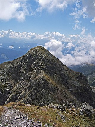
The Barmer Spitze is a peak of the Rieserferner group on the border between Tyrol, Austria, and South Tyrol, Italy.

The Piz dles Cunturines is a mountain in the Dolomites in South Tyrol, Italy.clean

The Langtauferer Spitze is a mountain in the Weisskamm group of the Ötztal Alps on the border between Tyrol, Austria, and South Tyrol, Italy.
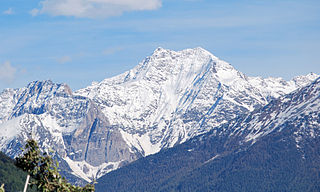
The Laaser Spitze, also Orgelspitze, is a mountain in the Ortler Alps in South Tyrol, Italy.
The Sarntal Alps are a mountain range of the Eastern Rhaetian Alps, in South Tyrol (Italy), which surrounds the Sarntal (valley). It is limited by the Etschtal, Eisacktal, Passeiertal and the Jaufen Pass.

The Villgraten Mountains or Deferegg Alps, also called the Defreggen Mountains are a subgroup of the Austrian Central Alps within the Eastern Alps of Europe. Together with the Ankogel Group, the Goldberg Group, the Glockner Group, the Schober Group, the Kreuzeck Group, the Granatspitze Group, the Venediger Group and the Rieserferner Group, the Villgraten Mountains are part of the major mountain range, the High Tauern. Their highest summit is the Weiße Spitze with a height of 2,962 m above sea level (AA).
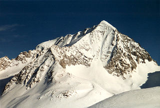
The Rieserferner Group is a mountain range in the Austrian Central Alps. Together with the Ankogel Group, Goldberg Group, Glockner Group, Schober Group, Kreuzeck Group, Granatspitze Group, Venediger Group and the Villgraten Mountains the group is part of the High Tauern. The Rieserferner mountains extend across the Austrian state of Tyrol and the Italian province of South Tyrol. The mountains mainly lie in South Tyrol, where the greater part is protected within the Rieserferner-Ahrn Nature Park.

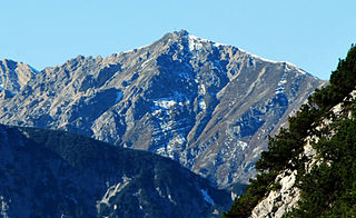
The Reither Spitze is a mountain in the Karwendel in the Austrian federal state of Tyrol that, thanks to its location at the southwestern end of the Erlspitze Group, is particularly well known for its great views of the surrounding area from its summit. Its name is derived the village of Reith bei Seefeld, which lies at its southwestern foot.

The Schlossbach is a river of Tyrol, Austria, a left tributary of the Inn.

The Nördlinger Hut is an Alpine Club hut belonging to the German Alpine Club that is situated at a height of 2,238 m (AA) south of the summit of the Reither Spitze in the Austrian state of Tyrol. It is thus the highest refuge hut in the entire Karwendel range. It is located in the westernmost part of the Karwendel Alps, the Erlspitze Group, above the village and ski resort of Seefeld. From the hut there are expansive views over the Stubai Alps, the Inn valley and the Wetterstein Mountains.
The Seefelder Spitze is a mountain east of Seefeld in Tirol in the Karwendel Alps in the Austrian state of Tyrol. It is 2,221 metres high and there is a summit cross at the top.
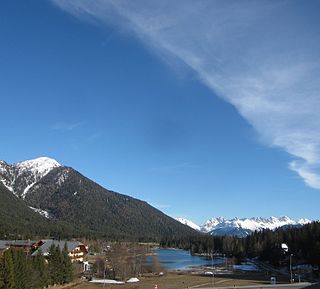
The Seefeld Saddle is a saddle and mountain pass, 1,185 m (AA), in the Northern Limestone Alps in the Austrian federal state of Tyrol. Two major transport routes run over it: the Seefelder Straße (B 177) and the Mittenwald Railway. On the Seefeld Plateau north of the saddle lies the village and ski resort of Seefeld in Tirol.
