
A road surface or pavement is the durable surface material laid down on an area intended to sustain vehicular or foot traffic, such as a road or walkway. In the past, gravel road surfaces, cobblestone and granite setts were extensively used, but these surfaces have mostly been replaced by asphalt or concrete laid on a compacted base course. Asphalt mixtures have been used in pavement construction since the beginning of the twentieth century. These roads are of two types: metalled roads and unmetalled roads. Metalled roadways are made to sustain vehicular load, so these type of surfaces are usually made on frequently-used roads. Unmetalled roads, also known as gravel roads, are rough and can't sustain a lot of weight. Road surfaces are frequently marked to guide traffic. Today, permeable paving methods are beginning to be used for low-impact roadways and walkways. Pavements are crucial to countries such as US and Canada, which heavily depend on road transportation. Therefore, research projects such as Long-Term Pavement Performance have been launched to optimize the life-cycle of different road surfaces.
A dipstick is one of several measurement devices.

A falling weight deflectometer (FWD) is a testing device used by civil engineers to evaluate the physical properties of pavement. FWD data is primarily used to estimate pavement structural capacity for 1) overlay design and 2) to determine if a pavement is being overloaded. Use includes highways, local roads, airport pavements, harbor areas and railway tracks. The machine is usually contained within a trailer that can be towed to a location by another vehicle. It can also be built on a pickup truck or inside a mini van. There are also comprehensive units where a FWD device is mounted on a heavy truck together with a GPR cart and a TMA protection to have a complete road survey vehicle.
In materials science, fracture toughness is the critical stress intensity factor of a sharp crack where propagation of the crack suddenly becomes rapid and unlimited. The critical value of stress intensity factor in mode I loading measured under plane strain conditions is known as the plane strain fracture toughness, denoted . Fracture toughness is a quantitative way of expressing a material's resistance to crack propagation and standard values for a given material are generally available.

A rut is a depression or groove worn into a road or path by the travel of wheels or skis. Ruts can be formed by wear, as from studded snow tires common in cold climate areas, or they can form through the deformation of the asphalt concrete, pavement or subbase material. In modern roads the main cause is heavily loaded trucks. These heavy loaded trucks imprint their tire impressions on roads over time, causing ruts. Rut is a common pavement distress and is often used in pavement performance modeling.

Geotechnical investigations are performed by geotechnical engineers or engineering geologists to obtain information on the physical properties of soil earthworks and foundations for proposed structures and for repair of distress to earthworks and structures caused by subsurface conditions. This type of investigation is called a site investigation. Additionally, geotechnical investigations are also used to measure the thermal resistivity of soils or backfill materials required for underground transmission lines, oil and gas pipelines, radioactive waste disposal, and solar thermal storage facilities. A geotechnical investigation will include surface exploration and subsurface exploration of a site. Sometimes, geophysical methods are used to obtain data about sites. Subsurface exploration usually involves soil sampling and laboratory tests of the soil samples retrieved.

A sieve analysis is a practice or procedure used to assess the particle size distribution of a granular material by allowing the material to pass through a series of sieves of progressively smaller mesh size and weighing the amount of material that is stopped by each sieve as a fraction of the whole mass.
Pavement management is the process of planning the maintenance and repair of a network of roadways or other paved facilities in order to optimize pavement conditions over the entire network.
Road surface textures are deviations from a planar and smooth surface, affecting the vehicle/tyre interaction. Pavement texture is divided into: microtexture with wavelengths from 0 mm to 0.5 millimetres (0.020 in), macrotexture with wavelengths from 0.5 millimetres (0.020 in) to 50 millimetres (2.0 in) and megatexture with wavelengths from 50 millimetres (2.0 in) to 500 millimetres (20 in).

Crocodile cracking, also called alligator cracking and perhaps misleadingly fatigue cracking, is a common type of distress in asphalt pavement. The following is more closely related to fatigue cracking which is characterized by interconnecting or interlaced cracking in the asphalt layer resembling the hide of a crocodile. Cell sizes can vary in size up to 11.80 inches (300 mm) across, but are typically less than 5.90 inches (150 mm) across. Fatigue cracking is generally a loading failure, but numerous factors can contribute to it. It is often a sign of sub-base failure, poor drainage, or repeated over-loadings. It is important to prevent fatigue cracking, and repair as soon as possible, as advanced cases can be very costly to repair and can lead to formation of potholes or premature pavement failure.

The International Roughness Index (IRI) is the roughness index most commonly obtained from measured longitudinal road profiles. It is calculated using a quarter-car vehicle math model, whose response is accumulated to yield a roughness index with units of slope. This performance measure has less stochasticity and subjectivity in comparison to other pavement performance indicators, but it is not completely devoid of randomness. The sources of variability in IRI data include the difference among the readings of different runs of the test vehicle and the difference between the readings of the right and left wheel paths. Despite these facts, since its introduction in 1986, the IRI has become the road roughness index most commonly used worldwide for evaluating and managing road systems.

Package testing or packaging testing involves the measurement of a characteristic or property involved with packaging. This includes packaging materials, packaging components, primary packages, shipping containers, and unit loads, as well as the associated processes.
Infrastructure asset management is the integrated, multidisciplinary set of strategies in sustaining public infrastructure assets such as water treatment facilities, sewer lines, roads, utility grids, bridges, and railways. Generally, the process focuses on the later stages of a facility's life cycle, specifically maintenance, rehabilitation, and replacement. Asset management specifically uses software tools to organize and implement these strategies with the fundamental goal to preserve and extend the service life of long-term infrastructure assets which are vital underlying components in maintaining the quality of life in society and efficiency in the economy. In the 21st century, climate change adaptation has become an important part of infrastructure asset management competence.
In analytical chemistry, the hydroxyl value is defined as the number of milligrams of potassium hydroxide required to neutralize the acetic acid taken up on acetylation of one gram of a chemical substance that contains free hydroxyl groups. Hydroxyl value is a measure of the content of free hydroxyl groups in a chemical substance, usually expressed in units of the mass of potassium hydroxide (KOH) in milligrams equivalent to the hydroxyl content of one gram of the chemical substance. The analytical method used to determine hydroxyl value traditionally involves acetylation of the free hydroxyl groups of the substance with acetic anhydride in pyridine solvent. After completion of the reaction, water is added, and the remaining unreacted acetic anhydride is converted to acetic acid and measured by titration with potassium hydroxide.
The PASER scale is a 1-10 rating system for road pavement condition developed by the University of Wisconsin-Madison Transportation Information Center. PASER uses visual inspection to evaluate pavement surface conditions. When assessed correctly, PASER ratings provide a basis for comparing the quality of roadway segments. The PASER assessment method does not require measurements of individual distresses, and thus PASER ratings cannot be disaggregated into measurements of specific distress types. The advantage to this method is that roads may be assessed quickly, possibly even by "windshield survey." A primary disadvantage is that because PASER ratings cannot be disaggregated into component distress data, the metric cannot be used in mechanistic-empirical transportation asset management programs.
Bleeding or flushing is shiny, black surface film of asphalt on the road surface caused by upward movement of asphalt in the pavement surface. Common causes of bleeding are too much asphalt in asphalt concrete, hot weather, low space air void content and quality of asphalt. Bleeding is a safety concern since it results in a very smooth surface, without the texture required to prevent hydroplaning. Road performance measures such as IRI cannot capture the existence of bleeding as it does not increase the surface roughness. But other performance measures such as PCI do include bleeding.

A reflective crack is a type of failure in asphalt pavement, one of the most popular road surface types. Asphalt pavement is impacted by traffic and thermal loading. Due to loading, cracks can appear on pavement surface that can reduce the Pavement Condition Index(PCI) dramatically.

Pavement performance modeling or pavement deterioration modeling is the study of pavement deterioration throughout its life-cycle. The health of pavement is assessed using different performance indicators. Some of the most well-known performance indicators are Pavement Condition Index (PCI), International Roughness Index (IRI) and Present Serviceability Index (PSI), but sometimes a single distress such as rutting or the extent of crack is used. Among the most frequently used methods for pavement performance modeling are mechanistic models, mechanistic-empirical models, survival curves and Markov models. Recently, machine learning algorithms have been used for this purpose as well. Most studies on pavement performance modeling are based on IRI.
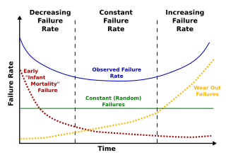
Deterioration modeling is the process of modeling and predicting the physical conditions of structures or infrastructure. The condition of infrastructure is represented either using a deterministic index or the probability of failure. Examples of such performance measures are pavement condition index for roads or bridge condition index for bridges. For probabilistic measures, which are the focus of reliability theory, probability of failure or reliability index are used. Deterioration models are instrumental to infrastructure asset management and are the basis for maintenance and rehabilitation decision-making. The condition of all physical infrastructure degrade over time. A deterioration model can help decision-makers to understand how fast the condition drops or violates a certain threshold.
Levels of service (LOS) is a term in asset management referring to the quality of a given service. Defining and measuring levels of service is a key activity in developing infrastructure asset management plans. Levels of service may be tied to physical performance of assets or be defined via customer expectation and satisfaction. The latter is more service-centric rather than asset-centric. For instance, when measuring the LOS of a road, it could be measured by a physical performance indicator such as Pavement Condition Index (PCI) or by a measure related to customer satisfaction such as the number of complaints per month about that certain road section. Or in the case of traffic level of service, it could be measured by the geometry of road or by travel time of the vehicles, which reflects the quality of traffic flow. So, levels of service can have multiple facets: customer satisfaction, environmental requirements and legal requirements.

