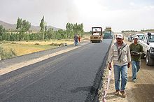
A road is a thoroughfare for the conveyance of traffic that mostly has an improved surface for use by vehicles and pedestrians. Unlike streets, whose primary function is to serve as public spaces, the main function of roads is transportation.
Energy-efficient landscaping is a type of landscaping designed for the purpose of conserving energy. There is a distinction between the embedded energy of materials and constructing the landscape, and the energy consumed by the maintenance and operations of a landscape.

Highway engineering is a professional engineering discipline branching from the civil engineering subdiscipline of transportation engineering that involves the planning, design, construction, operation, and maintenance of roads, highways, streets, bridges, and tunnels to ensure safe and effective transportation of people and goods. Highway engineering became prominent towards the latter half of the 20th century after World War II. Standards of highway engineering are continuously being improved. Highway engineers must take into account future traffic flows, design of highway intersections/interchanges, geometric alignment and design, highway pavement materials and design, structural design of pavement thickness, and pavement maintenance.

A road surface or pavement is the durable surface material laid down on an area intended to sustain vehicular or foot traffic, such as a road or walkway. In the past, gravel road surfaces, macadam, hoggin, cobblestone and granite setts were extensively used, but these have mostly been replaced by asphalt or concrete laid on a compacted base course. Asphalt mixtures have been used in pavement construction since the beginning of the 20th century and are of two types: metalled (hard-surfaced) and unmetalled roads. Metalled roadways are made to sustain vehicular load and so are usually made on frequently used roads. Unmetalled roads, also known as gravel roads or dirt roads, are rough and can sustain less weight. Road surfaces are frequently marked to guide traffic.

Asphalt concrete is a composite material commonly used to surface roads, parking lots, airports, and the core of embankment dams. Asphalt mixtures have been used in pavement construction since the beginning of the twentieth century. It consists of mineral aggregate bound together with bitumen, laid in layers, and compacted.

Permeable paving surfaces are made of either a porous material that enables stormwater to flow through it or nonporous blocks spaced so that water can flow between the gaps. Permeable paving can also include a variety of surfacing techniques for roads, parking lots, and pedestrian walkways. Permeable pavement surfaces may be composed of; pervious concrete, porous asphalt, paving stones, or interlocking pavers. Unlike traditional impervious paving materials such as concrete and asphalt, permeable paving systems allow stormwater to percolate and infiltrate through the pavement and into the aggregate layers and/or soil below. In addition to reducing surface runoff, permeable paving systems can trap suspended solids, thereby filtering pollutants from stormwater.

A pothole is a depression in a road surface, usually asphalt pavement, where traffic has removed broken pieces of the pavement. It is usually the result of water in the underlying soil structure and traffic passing over the affected area. Water first weakens the underlying soil; traffic then fatigues and breaks the poorly supported asphalt surface in the affected area. Continued traffic action ejects both asphalt and the underlying soil material to create a hole in the pavement.
The pavement condition index (PCI) is a numerical index between 0 and 100, which is used to indicate the general condition of a pavement section. The PCI is widely used in transportation civil engineering and asset management, and many municipalities use it to measure the performance of their road infrastructure and their levels of service. It is a statistical measure and requires manual survey of the pavement. This index was originally developed by the United States Army Corps of Engineers as an airfield pavement rating system, but later modified for roadway pavements and standardized by the ASTM. The surveying processes and calculation methods have been documented and standardized by ASTM for both roads and airport pavements:

Geotechnical investigations are performed by geotechnical engineers or engineering geologists to obtain information on the physical properties of soil earthworks and foundations for proposed structures and for repair of distress to earthworks and structures caused by subsurface conditions; this type of investigation is called a site investigation. Geotechnical investigations are also used to measure the thermal resistance of soils or backfill materials required for underground transmission lines, oil and gas pipelines, radioactive waste disposal, and solar thermal storage facilities. A geotechnical investigation will include surface exploration and subsurface exploration of a site. Sometimes, geophysical methods are used to obtain data about sites. Subsurface exploration usually involves soil sampling and laboratory tests of the soil samples retrieved.

Chipseal is a pavement surface treatment that combines one or more layers of asphalt with one or more layers of fine aggregate. In the United States, chipseals are typically used on rural roads carrying lower traffic volumes, and the process is often referred to as asphaltic surface treatment. This type of surface has a variety of other names including tar-seal or tarseal, tar and chip, sprayed sealsurface dressing, or simply seal.
Pavement management is the process of planning the maintenance and repair of a network of roadways or other paved facilities in order to optimize pavement conditions over the entire network.
Road surface textures are deviations from a planar and smooth surface, affecting the vehicle/tyre interaction. Pavement texture is divided into: microtexture with wavelengths from 0 mm to 0.5 millimetres (0.020 in), macrotexture with wavelengths from 0.5 millimetres (0.020 in) to 50 millimetres (2.0 in) and megatexture with wavelengths from 50 millimetres (2.0 in) to 500 millimetres (20 in).

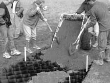
Cellular confinement systems (CCS)—also known as geocells—are widely used in construction for erosion control, soil stabilization on flat ground and steep slopes, channel protection, and structural reinforcement for load support and earth retention. Typical cellular confinement systems are geosynthetics made with ultrasonically welded high-density polyethylene (HDPE) strips or novel polymeric alloy (NPA)—and expanded on-site to form a honeycomb-like structure—and filled with sand, soil, rock, gravel or concrete.

Crocodile cracking is a common type of distress in asphalt pavement. The following is more closely related to fatigue cracking which is characterized by interconnecting or interlaced cracking in the asphalt layer resembling the hide of a crocodile. Cell sizes can vary in size up to 300 millimetres (12 in) across, but are typically less than 150 millimetres (5.9 in) across. Fatigue cracking is generally a loading failure, but numerous factors can contribute to it. It is often a sign of sub-base failure, poor drainage, or repeated over-loadings. It is important to prevent fatigue cracking, and repair as soon as possible, as advanced cases can be very costly to repair and can lead to formation of potholes or premature pavement failure.

The international roughness index (IRI) is the roughness index most commonly obtained from measured longitudinal road profiles. It is calculated using a quarter-car vehicle math model, whose response is accumulated to yield a roughness index with units of slope. Although a universal term, IRI is calculated per wheelpath, but can be expanded to a Mean Roughness Index (MRI) when both wheelpath profiles are collected. This performance measure has less stochasticity and subjectivity in comparison to other pavement performance indicators, such as PCI, but it is not completely devoid of randomness. The sources of variability in IRI data include the difference among the readings of different runs of the test vehicle and the difference between the readings of the right and left wheel paths. Despite these facts, since its introduction in 1986, the IRI has become the road roughness index most commonly used worldwide for evaluating and managing road systems.
Geoprofessions is a term coined by the Geoprofessional Business Association to connote various technical disciplines that involve engineering, earth and environmental services applied to below-ground ("subsurface"), ground-surface, and ground-surface-connected conditions, structures, or formations. The principal disciplines include, as major categories:

The Communication and Works Department is a department of the Government of Punjab, Pakistan. It is responsible for the planning, execution, maintenance, and repair of infrastructure projects in the province, including bridges, public buildings, and roads.
Container port design process is a set of correlated practices considered during container port design, aiming to transfer general business mission into detailed design documents for future construction and operation.

Pavement performance modeling or pavement deterioration modeling is the study of pavement deterioration throughout its life-cycle. The health of pavement is assessed using different performance indicators. Some of the most well-known performance indicators are Pavement Condition Index (PCI), International Roughness Index (IRI) and Present Serviceability Index (PSI), but sometimes a single distress such as rutting or the extent of crack is used. Among the most frequently used methods for pavement performance modeling are mechanistic models, mechanistic-empirical models, survival curves and Markov models. Recently, machine learning algorithms have been used for this purpose as well. Most studies on pavement performance modeling are based on IRI.
The Neoloy Geocell is a Cellular Confinement System (geocell) developed and manufactured by PRS Geo-Technologies Ltd. Geocells are extruded in ultrasonically welded strips. The folded strips are opened on-site to form a 3D honeycomb matrix, which is then filled with granular material. The 3D confinement system is used to stabilize soft subgrade soil and reinforce the subbase and base layers in flexible pavements. Cellular confinement is also used for soil protection and erosion control for slopes, including channels, retention walls, reservoirs and landfills.


