
The Trans Canada Trail, officially named The Great Trail between September 2016 and June 2021, is a cross-Canada system of greenways, waterways, and roadways that stretches from the Atlantic to the Pacific to the Arctic oceans. The trail extends over 24,000 km (15,000 mi); it is now the longest recreational, multi-use trail network in the world. The idea for the trail began in 1992, shortly after the Canada 125 celebrations. Since then it has been supported by donations from individuals, corporations, foundations, and all levels of government.

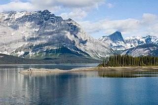
Kananaskis Country is a multi-use area west of Calgary, Alberta, Canada in the foothills and front ranges of the Canadian Rockies. The area is named for the Kananaskis River, which was named by John Palliser in 1858 after a Cree acquaintance. Covering an area of approximately 4,000 km2 (1,500 sq mi), Kananaskis Country was formed by the Alberta Government in 1978 to provide an assortment of land uses and designations. Land uses include resource extraction activities, recreation, power generation, and residential communities. Land designations include public land and protected areas.

Willmore Wilderness Park, in Alberta, Canada, is a 4,600-square-kilometre (1,800 sq mi) wilderness area adjacent to Jasper National Park. It is lesser known and less visited than Jasper National Park. There are no public roads, bridges or buildings. There are, however, several ranger cabins in the park that are available as a courtesy to visitors.

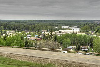
Peace River, originally named Peace River Crossing and known as Rivière-la-Paix in French, is a town in northwest Alberta, Canada. It is along the banks of the Peace River at its confluence with the Smoky River, the Heart River and Pat's Creek. It is approximately 486 kilometres (302 mi) northwest of Edmonton and 198 kilometres (123 mi) northeast of Grande Prairie on Highway 2. It was known as the Village of Peace River Crossing between 1914 and 1916.

Whitecourt is a town in Northern Alberta, Canada that is surrounded by Woodlands County. It is approximately 177 km (110 mi) northwest of Edmonton and 279 km (173 mi) southeast of Grande Prairie at the junction of Highway 43 and Highway 32. It has an elevation of 690 m (2,260 ft).
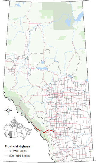
Alberta Provincial Highway No. 2, commonly referred to as Highway 2 or the Queen Elizabeth II Highway, is a major highway in Alberta that stretches from the Canada–United States border through Calgary and Edmonton to Grande Prairie. Running primarily north to south for approximately 1,273 kilometres (791 mi), it is the longest and busiest highway in the province carrying more than 170,000 vehicles per day near Downtown Calgary. The Fort Macleod—Edmonton section forms a portion of the CANAMEX Corridor that links Alaska to Mexico. More than half of Alberta's 4 million residents live in the Calgary–Edmonton Corridor created by Highway 2.

Alberta Provincial Highway No. 22, commonly referred to as Highway 22 and officially named Cowboy Trail, is a 584-kilometre (363 mi) highway in the Canadian province of Alberta. It generally parallels Highway 2, beginning in the foothills of southern Alberta at Highway 3 near Lundbreck Falls. It proceeds north along the eastern slopes of the Rocky Mountains passing through the foothills and ranch country to the aspen parkland of northern Alberta, ending at Highway 18 near Mayerthorpe.
Alberta Provincial Highway No. 1, commonly referred to as Highway 1, is a major east–west highway in southern Alberta that forms the southern mainline of the Trans-Canada Highway. It runs from the British Columbia border near Lake Louise through Calgary to the Saskatchewan border east of Medicine Hat. It continues as Highway 1 into both provinces. It spans approximately 534 km (332 mi) from Alberta's border with British Columbia in the west to its border with Saskatchewan in the east. Highway 1 is designated as a core route in Canada's National Highway System and is a core part of the developing Alberta Freeway Network.
Fort Assiniboine is a hamlet in northwest Alberta, Canada, within Woodlands County. It is located along the north shore of the Athabasca River at the junction of Highway 33 and Highway 661. It is approximately 39 kilometres (24 mi) northwest of Barrhead, 62 kilometres (39 mi) southeast of Swan Hills and 91 kilometres (57 mi) northeast of Whitecourt.
Alberta Provincial Highway No. 1A is the designation of two alternate routes off the Alberta portion of Trans-Canada Highway 1. However, it is not the only name used for spurs off Highway 1 - Highway 1X is another such designation. Despite these highways being suffixed routes of Highway 1, they are not part of the Trans-Canada Highway network, and are signed with Alberta's provincial primary highway shields instead of the Trans-Canada shields used for Highway 1.
Peter Lougheed Provincial Park is in Kananaskis Country about 90 kilometres (56 mi) west of Calgary, along the Kananaskis Trail in Alberta, Canada.

Grimshaw is a town in northern Alberta, Canada. It is approximately 25 km (16 mi) west of the Town of Peace River at the junction of Highway 2 and Highway 2A and along Mackenzie Northern Railway. By virtue of being the original starting point of Highway 35, which leads to the Northwest Territories, Grimshaw is referred to as Mile Zero of the Mackenzie Highway.

Swan Hills is a town in northern Alberta, Canada. It is in the eponymous Swan Hills, approximately 80 km (50 mi) north of Whitecourt and 62 km (39 mi) northwest of Fort Assiniboine. The town is at the junction of Highway 32 and Grizzly Trail, and is surrounded by Big Lakes County.
Berwyn is a village in northwestern Alberta, Canada. It is located approximately 37 km (23 mi) west of the Town of Peace River, 10 km (6.2 mi) southwest of the Town of Grimshaw, and 15 km (9.3 mi) northeast of the Duncan's First Nation reserve.

The Municipal District of Greenview No. 16 is a municipal district (MD) in northwest Alberta, Canada. It covers the full extent of Census Division 18, and with an area of 32,984 km2 (12,735 sq mi), it is the largest municipal district in Alberta. Its administrative office is located in the Town of Valleyview.

The Northern Woods and Water Route is a 2,400-kilometre (1,500 mi) route through northern British Columbia, Alberta, Saskatchewan and Manitoba in Western Canada. As early as the 1950s, community groups came together to establish a northern travel route; this was proposed as the Northern Yellowhead Transportation Route. The Northern Woods and Water Route Association was established in 1974, and encouraged promotion of the route with the promise of an increase in tourist travel. The route was designated in 1974 and is well signed throughout its component highways. The route starts at Dawson Creek as the Spirit River Highway and ends at the Perimeter of Winnipeg, Manitoba, after running through the northern regions of the western provinces. From west to east, the Northern Woods and Water Route (NWWR) incorporates portions of British Columbia Highway 49; Alberta Highways 49, 2A, 2, & 55; Saskatchewan Highways 55 & 9; Manitoba Provincial Road 283 and Trunk Highways 10, 5, 68 & 6. The halfway point of the NWWR is approximately at Goodsoil, Saskatchewan.
Saskatchewan has a transportation infrastructure system of roads, highways, freeways, airports, ferries, pipelines, trails, waterways, and railway systems serving a population of approximately 1,132,505 inhabitants year-round.
Brownvale is a hamlet in northern Alberta, Canada within the Municipal District of Peace No. 135. It is located on Highway 737 less than 1 kilometre (0.62 mi) off Highway 2, approximately 48 kilometres (30 mi) southwest of the Town of Peace River and 20 kilometres (12 mi) southwest of Grimshaw. Duncan's First Nation reserve is less than 5 km (3.1 mi) to the south.
Marten Beach is a hamlet in northern Alberta, Canada, within the Municipal District of Lesser Slave River No. 124. It is located on the northeast shore of Lesser Slave Lake, 2 kilometres (1.2 mi) west of Highway 88. It is approximately 36 kilometres (22 mi) north of the Town of Slave Lake and 238 kilometres (148 mi) northwest of the City of Edmonton.

Peace River Wildland Provincial Park is located in the valley of the Peace River stretching from Dunvegan Provincial Park to the Smoky River confluence and 30 kilometers upstream of the Smoky River valley. Also included in the park is the Spirit River valley at the confluence with the Peace. While most of the park lies in the Birch Hills County, some of it is in the Northern Sunrise County immediately south of the Town of Peace River.
