Austria is a predominantly mountainous country in Central Europe, approximately between Germany, Italy and Hungary. It has a total area of 83,871 square kilometres (32,383 sq mi).

The history of Tyrol, a historical region in the middle alpine area of Central Europe, dates back to early human settlements at the end of the last glacier period, around 12,000 BC. Sedentary settlements of farmers and herders can be traced back to 5000 BC. Many of the main and side valleys were settled during the early Bronze Age, from 1800 to 1300 BC. From these settlements, two prominent cultures emerged: the Laugen-Melaun culture in the Bronze Age, and the Fritzens-Sanzeno culture in the Iron Age.

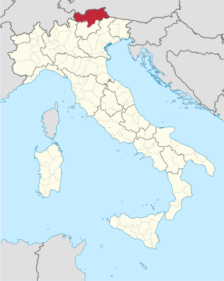
South Tyrol is an autonomous province in northern Italy. An English translation of the official German and Italian names could be the Autonomous Province of Bolzano – South Tyrol, reflecting the multilingualism and different naming conventions in the area. Together with the autonomous province of Trento, South Tyrol forms the autonomous region of Trentino-Alto Adige/Südtirol. The province is the northernmost of Italy, the second largest with an area of 7,400 square kilometres (2,857 sq mi), and has a total population of about 534,000 inhabitants as of 2021. Its capital and largest city is Bolzano.

Bolzano is the capital city of the province of South Tyrol, in Northern Italy. With a population of 108,245, Bolzano is also by far the largest city in South Tyrol and the third largest in historical Tyrol. The greater metro area has about 250,000 inhabitants and is one of the urban centers within the Alps.

Trentino-Alto Adige/Südtirol is an autonomous region of Italy, located in the northern part of the country. The region has a population of 1.1 million, of whom 62% speak Italian as their mother tongue, 30% speak South Tyrolean German and several foreign languages are spoken by immigrant communities. Since the 1970s, most legislative and administrative powers have been transferred to the two self-governing provinces that make up the region: the province of Trento, commonly known as Trentino, and the province of Bolzano, commonly known as South Tyrol. In South Tyrol, German remains the sizeable majority language.

Cortina d'Ampezzo is a town and comune in the heart of the southern (Dolomitic) Alps in the province of Belluno, in the Veneto region of Northern Italy. Situated on the Boite river, in an alpine valley, it is an upscale summer and winter sport resort known for its skiing trails, scenery, accommodation, shops and après-ski scene, and for its jet set and Italian aristocratic crowd.

The Kitzbühel Alps are a mountain range of the Central Eastern Alps surrounding the town of Kitzbühel in Tyrol, Austria. Geologically they are part of the western slate zone.

Provincia autonoma di Trento, commonly known as Trentino, is an autonomous province of Italy in the country's far north. Trentino and South Tyrol constitute the region of Trentino-Alto Adige/Südtirol, an autonomous region under the constitution. The province is composed of 166 comuni. Its capital is the city of Trento (Trent). The province covers an area of more than 6,000 km2 (2,300 sq mi), with a total population of 541,098 in 2019. Trentino is renowned for its mountains, such as the Dolomites, which are part of the Alps.

Modern-day South Tyrol, an autonomous Italian province created in 1948, was part of the Austro-Hungarian County of Tyrol until 1918. It was annexed by Italy following the defeat of the Central Powers in World War I. It has been part of a cross-border joint entity, the Euroregion Tyrol-South Tyrol-Trentino, since 2001.

The Sella group is a plateau-shaped massif in the Dolomites mountains of northern Italy. The Sella lies north of the Marmolada and to the east of the Langkofel. The highest peak is Piz Boè at 3,151 m (10,338 ft) above sea level.

The Via Claudia Augusta is an ancient Roman road, which linked the valley of the Po River with Rhaetia across the Alps.

The Tre Cime di Lavaredo, also called the Drei Zinnen ; pronounced[ˌdʁaɪˈtsɪnən] ), are three distinctive battlement-like peaks, in the Sexten Dolomites of northeastern Italy. They are probably one of the best-known mountain groups in the Alps. The three peaks, from east to west, are:

Obertilliach is a municipality in the district of Lienz, in the Austrian state of Tyrol.

The Allgäu Alps are a mountain range in the Northern Limestone Alps, located in Bavaria and Baden-Württemberg in Germany and Tyrol and Vorarlberg in Austria. The range lies directly east of Lake Constance.

The South Tyrol Alpine Club, abbreviated AVS, is an association of German and Ladin-speaking mountain climbers in South Tyrol, northern Italy. Founded in 1946, it is subdivided into 32 sections and 58 local divisions. The AVS is based in Bolzano and has more than 60,000 members.

Speikboden is a massif in the Central Eastern Alps located between the three valleys Weißenbach, Mühlwald and Ahrntal. Running in a south-easterly direction, it forms the eastern part of an outlier of the western Zillertal Alps. Its highest point, likewise named Speikboden, is 2,517 m. Further well-known peaks in this massif include Seewassernock (2,516 m), Große Nock (2,400 m), Kleine Nock (2,227 m) and Gornerberg (2,475 m).

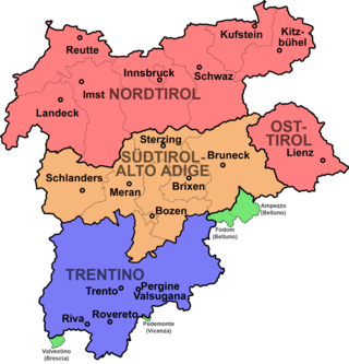
Tyrol is a historical region in the Alps of Northern Italy and western Austria. The area was historically the core of the County of Tyrol, part of the Holy Roman Empire, Austrian Empire and Austria-Hungary, from its formation in the 12th century until 1919. In 1919, following World War I and the dissolution of Austria-Hungary, it was divided into two modern administrative parts through the Treaty of Saint-Germain-en-Laye:

Ladinia is a neologism used to describe an Alpine region in the Dolomites mountain range of Northern Italy, divided between the Italian provinces of Belluno, South Tyrol, and Trento. The area takes its name from its inhabitants, the Ladin people, a Romance-speaking ethnic group. Their Ladin language is generally considered a Rhaeto-Romance language, though there is a scientific debate if it forms part of a wider northern Italian dialect continuum.

Tofana di Rozes is a mountain of the Dolomites in the Province of Belluno, Veneto, Italy. Located west of the resort of Cortina d'Ampezzo, the mountain's giant three-edged pyramid shape and its vertical south face, above the Falzarego Pass, makes it the most popular peak in the Tofane group, and one of the most popular in the Dolomites.
The Association for Active Remembrance Culture Alpine Peace Crossing is an Austrian initiative based in Krimml (Salzburg), founded by Salzburg-born Ernst Löschner to commemorate the long-forgotten escape of Jews across the Austrian Alps in 1947. It is dedicated to active remembrance and commemoration work. Once a year, it organises a commemorative hike across the Krimml Tauern along the path of the thousands of Jews who had to flee this way in 1947. Since 2020, the initiative has also published the association's own magazine, Alpendistel.


