
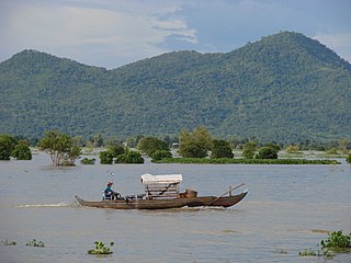
Tonlé Sap (; Khmer: ទន្លេសាប, Tônlé Sab ; lit. 'Fresh River' or commonly translated as 'Great Lake' is a lake in the northwest of Cambodia. Belonging to the Mekong River system, Tonlé Sap is the largest freshwater lake in Southeast Asia and one of the most diverse and productive ecosystems in the world. It has been designated as a Biosphere Reserve by UNESCO in 1997 due to its high biodiversity. In the 21st century, the lake and its surrounding ecosystems are under increasing pressure from deforestation, infrastructure development and climate change.
Kampong Chhnang is one of the central provinces (khaet) of Cambodia. Neighboring provinces are Kampong Thom, Kampong Cham, Kandal, Kampong Speu, and Pursat. The provincial capital is the city of Kampong Chhnang.

Kampong Thom is a province (khaet) of Cambodia. It borders the provinces of Siem Reap to the northwest, Preah Vihear to the north, Stung Treng to the northeast, Kratie to the east, Kampong Cham and Kampong Chhnang to the south, and the Tonle Sap to the west.

Pursat is a province of Cambodia. It is in the western part of the country and borders clockwise from the north: Battambang province, the Tonlé Sap, Kampong Chhnang province, Kampong Speu province, Koh Kong province, and East Thailand. It lies between the Tonle Sap and the northern end of the Cardamom Mountains. The Pursat River bisects the province, running from the Cardamoms in the west to the Tonle Sap in the east.
Siem Reap, officially Siemreap, is a province (khaet) of Cambodia. It borders the provinces of Oddar Meanchey to the north, Preah Vihear and Kampong Thom to the east, Battambang to the south, and Banteay Meanchey to the west. Its capital and largest city is Siem Reap.

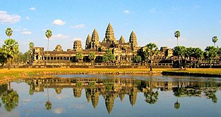
Siem Reap is the second-largest city of Cambodia, as well as the capital and largest city of Siem Reap Province in northwestern Cambodia.

Kampong Chhnang is the capital city of Kampong Chhnang Province, in central Cambodia.
Batheay is a district (srok) of Kampong Cham province, Cambodia. The district capital is Ph'av town. The town is located on National Highway 6 around 64 kilometres east of the provincial capital at Kampong Cham city and 60 kilometres north of the Cambodian capital Phnom Penh. The district lies at the junction between two major waterways, the Mekong River and the Tonle Sap.
Bakan is a district in Pursat province, Cambodia. The district capital is at Trapeang Chong located on National Highway 5 around 15 kilometres north of the provincial capital at Pursat town.
Kandieng is a district in Pursat province, Cambodia. The district capital is at Kandieng town located about 12 km from the Provincial capital Pursat.
Krakor is a district in Pursat province, Cambodia. The district capital is Krakor town located 25 kilometres east of the provincial capital, Pursat town.
Baribour is a district (srok) in the north of Kampong Chhnang province, in central Cambodia. The district capital is Baribour town located around 38 kilometres north west of the provincial capital of Kampong Chhnang by road. The district shares a border with Pursat province to the west and with Kampong Thom province to the north. The district borders on the Tonle Sap and the Tonle Sap river forms the northern and eastern borders of the district.
Chol Kiri is a district (srok) in the east of Kampong Chhnang province, in central Cambodia. The district capital is Chol Kiri town located around eight km (5.0 mi) south of the provincial capital of Kampong Chhnang by road. Chol Kiri district is the easternmost district of Kampong Chhnang. The district shares a border with Kampong Thom and Kampong Cham provinces to the east. Most of the district is low lying floodplain and the Tonlé Sap river runs through the district roughly from north to south. This proximity to the river and the lack of high land make Chol Kiri one of the most flood prone districts in the country. The Kampong Chhnang Department of Development has estimated that both Chol Kiri and Kampong Leaeng districts are flooded for six months of the year and that after the floodwaters have receded drinking water sources are left contaminated.
Kampong Leaeng is a district (srok) in the north east of Kampong Chhnang province, in central Cambodia. The district capital is Kampong Leaeng town located around 4 kilometres east of the provincial capital of Kampong Chhnang in a direct line. Kampong Leaeng district is the northernmost district of Kampong Chhnang. The district shares a border with Kampong Thom province to north and east. Much of the district is low-lying floodplain and the Tonle Sap river runs through the district roughly from north to south. In the south of the district are two significant mountains. Phnom Chrak Tunling and Phnom Neang Kangrei both over 1000 metres in elevation.

Kampong Tralach is a district (srok) in the south east of Kampong Chhnang province, in central Cambodia. The district capital is Kampong Tralach town located 37 kilometres south of the provincial capital of Kampong Chhnang by road. The district shares a border with Kandal province to the south and Kampong Cham province to the east. The Tonle Sap river runs through the district crossing roughly from north to south.

Rolea B'ier is a district (srok) in the center of Kampong Chhnang province, in central Cambodia. The district capital is Rolea B'ier, a town located 5 kilometres south of the provincial capital of Kampong Chhnang. The district is surrounded by other Kampong Chhnang districts and in turn surrounds Kampong Chhnang district which includes the provincial capital. The Tonle Sap serves as the border of the district in the north east. The Kampong Chhnang Airport, built during the period of Democratic Kampuchea lies in Krang Leav commune.
Natural resources are materials that occur in a natural form within environments. These can be classified as either biotic or abiotic on the basis of their origin. The landmass and the territorial waters of Cambodia contain a rather moderate amount, array and variety of resources. Apart from water, abiotic resources, such as minerals are generally rare. Still, advanced geo-scientific technologies have produced remarkable results and re-assessments in recent years, such as the localization of offshore oil and gas depots in the Gulf of Thailand. Cambodia, on the other hand possesses a relatively wide range of biotic resources, in particular timber, forest products, rare plants and a fauna of great diversity.
Kampong Chhnang municipality is a municipality in the centre of Kampong Chhnang province in central Cambodia. This is classed as an urban district and the provincial capital Kampong Chhnang City lies within the municipality. The district is quite small and encompasses the provincial town and nearby communes. Kampong Chhnang is the smallest district in Kampong Chhnang province and is surrounded by other Kampong Chhnang districts. The Tonle Sap river lies on the north and eastern borders of the district.

Russey Keo, also spelled as Russei Keo, is a district (khan) in Phnom Penh, Cambodia. This district consists of the northern and north-eastern outskirts of the main city of Phnom Penh, stretching from Khan Sen Sok in the west to the Tonlé Sap River in the east. As of 2019, it is the most populous district of Phnom Penh.
The Tonlé Sap Biosphere Reserve is a unique ecological phenomenon surrounding the Tonlé Sap or Great Lake of Cambodia. In 1997, it was successfully nominated as a UNESCO Biosphere Reserve.
