Stoung District

Last updated
Stoung
ស្រុកស្ទោង
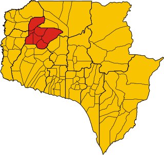
Cambodia adm location map.svg
Red pog.svg
Stoung
Location in Cambodia
Coordinates: 12°50′N104°35′E / 12.833°N 104.583°E / 12.833; 104.583
CountryFlag of Cambodia.svg  Cambodia
Province Kampong Thom
Time zone +7
Geocode0608

Stoung is a district within Kampong Thom Province, in central Cambodia. According to the 1998 census of Cambodia, it had a population of 94,119. [1]

Administration

The following table shows the villages of Sandaan District by commune.

Khum (Communes) Phum (Villages)
Banteay Stoung Ponlea Chey, Chanloh, Beng, Banteay Stoung, Kok Kruos, Kouk Sandaek, Chheu Teal, Pou, Sla Kar, Chambak Panhnha, Bar Veaeng, Roluos, Ta Maeu, Sraom Daek, Doun Pok
Chamna Kraom Preah Neangkoal, Sampoar, Srei Rongit, Svay Ie, Neang Noy, Sandan, Spean Krong, Chi Ab, Chamnak, Lieb
Chamna Leu Srang, Prasat, Trapeang Choar, Khmak, Kor, Lhong, Andoung Trom, Thlok, K'en, Phlaoch
Kampong Chen Cheung Tnaot, Chek, Chak, Roka, Neang Sa Lngeach, Trach,
Kampong Chen Tboung Chheu Teal, Leab Tong, Kampong Kdei, Kampong Chen, Chi Youk, Svay Sa, Nguon Siem
Msa Krang Ou Doung, Sambuor Tboung, Sambuor Cheung, Kouk Trea, Msa Krang Tboung, Msa Krang Cheung, Kampong Pradam, Bat Trang, Prakeab, Chi Meas, Sampan
Peam Bang Pov Veuy, Peam Bang, Doun Sderng
Popok Sambuor, Anlong Kranh, Kaoh Samraong, Krasang, Khtom Mon, Popok, Phteah Daeum, Trapeang Ruessei
Pralay Ang Khloam, Kampong Veang, Prey Khla, Pralay, Kouk Rovieng, Anlong Pring, Kampreal, Kanthean, Neang Sa Lngeach, Thmei, Kraek, Chhuk, Ta Treal, Srae Ta Maen
Preah Damrei Siem Peay, Cheah, Souphi, Luek, Kandaol Chas, Kandaol Thmei, Prasat, Samrang, Roluos
Rung Roeang Bos Ta Saom, Kantong Rong, Prum Srei, Svay Rieng, Botum Lech, Botum Kaeut, Kantaeub, Pou, Kdei Char
Samprouch Krasang Chrum Tboung, Krasang Chrum Cheung, Tnaot Kom, Samprouch, Kouk Snay, Pey, Chambak Khpos, Trach Chrum, Pophluk, Ampil, Mochheay, Doun L'a, Pradet, Lvea, Ou Rumchek, Ampov Prey, Slak Kranh
Trea Totea, Kaoh, Hab, Veal, Sam K'aok, Chrang Sa, Trea, Bos Ta Aek, Ta Char, Leab Tong, Phteah Veal, Sla, Krasang, Koch Tituy, Popeay, Tumpech

Related Research Articles

Kandal Stueng District District in Kandal, Cambodia

Kandal Stueng is a district (srok) of Kandal Province, Cambodia. The district is subdivided into 23 communes (khums) and 154 villages (phums).

Batheay District District in Kampong Cham, Cambodia

Batheay District is a district (srok) of Kampong Cham Province, Cambodia. The district capital is Ph'av town. The town is located on National Highway 6 around 64 kilometres east of the provincial capital at Kampong Cham city and 60 kilometres north of the Cambodian capital Phnom Penh. The district lies at the junction between two major waterways, the Mekong River and the Tonle Sap.

Kandieng District District in Pursat, Cambodia

Kandieng District is a district in Pursat Province, Cambodia. The district capital is at Kandieng town located about 12 km from the Provincial capital Pursat.

Krakor District District in Pursat, Cambodia

Krakor District is a district in Pursat Province, Cambodia. The district capital is Krakor town located 25 kilometres east of the provincial capital, Pursat town.

Barsedth District District in Kampong Speu, Cambodia

Barsedth is a district (srok) in the south of Kampong Speu Province, in southern Cambodia. The district capital is the town of Barsedth located some 50 kilometres south of the provincial capital of Kampong Speu by road. The district shares a border with Kampot and Takeo provinces to the south. National Highway 3 forms the eastern district boundary. The district is made up of flat farmland and supports extensive agriculture and a large population.

Aoral District District in Kampong Speu, Cambodia

Aoral District is a district located in Kampong Speu Province in central Cambodia. It includes Phnom Aural, the highest peak in Cambodia.

Thpong District District in Kampong Speu, Cambodia

Thpong District is a district (srok) located in Kampong Speu Province in central Cambodia.

Kampong Leaeng District District in Kampong Chhnang, Cambodia

Kampong Leaeng District is a district (srok) in the north east of Kampong Chhnang Province, in central Cambodia. The district capital is Kampong Leaeng town located around 4 kilometres east of the provincial capital of Kampong Chhnang in a direct line. Kampong Leaeng district is the northernmost district of Kampong Chhnang. The district shares a border with Kampong Thom province to north and east. Much of the district is low-lying floodplain and the Tonle Sap river runs through the district roughly from north to south. In the south of the district are two significant mountains. Phnom Chrak Tunling and Phnom Neang Kangrei both over 1000 metres in elevation.

Kampong Tralach District District in Kampong Chhnang, Cambodia

Kampong Tralach District is a district (srok) in the south east of Kampong Chhnang Province, in central Cambodia. The district capital is Kampong Tralach town located 37 kilometres south of the provincial capital of Kampong Chhnang by road. The district shares a border with Kandal province to the south and Kampong Cham province to the east. The Tonle Sap river runs through the district crossing roughly from north to south.

Rolea Bier District District in Kampong Chhnang, Cambodia

Rolea B'ier District is a district (srok) in the center of Kampong Chhnang Province, in central Cambodia. The district capital is Rolea B'ier, a town located 5 kilometres south of the provincial capital of Kampong Chhnang. The district is surrounded by other Kampong Chhnang districts and in turn surrounds Kampong Chhnang District which includes the provincial capital. The Tonle Sap serves as the border of the district in the north east. The Kampong Chhnang Airport, built during the period of Democratic Kampuchea lies in Krang Leav commune.

Kampong Svay District District in Kampong Thom, Cambodia

Kampong Svay is a district within Kampong Thom Province, in central Cambodia. According to the 1998 census of Cambodia, it had a population of 74,843.

Tuek Chhou District District in Kampot, Cambodia

Tuek Chhou District is a district located in Kampot Province, in southern Cambodia. It surrounds Krong Kampot, which contains the urban area of Kampot City.

Chong Kal District District in Oddar Meanchey, Cambodia

Chong Kal District is a district in Oddar Meancheay province in northern Cambodia. According to the 1998 census of Cambodia, it had a population of 18,843.

Samraong municipality Municipality in Oddar Meanchey, Cambodia

Samraong municipality is a municipality in Oddar Meanchey province in northern Cambodia. It is the urban part of the province. The provincial capital Samraong lies in the district. According to the 1998 census of Cambodia, it had a population of 22,361.

Choam Khsant District District in Preah Vihear, Cambodia

Choam Khsant District is a district located in Preah Vihear Province, in northern Cambodia. The district capital is at Cheom Ksan town, near the Thai border. Cambodia's famous Preah Vihear Temple is located in this district of the Preah Vihear province. According to the 1998 census of Cambodia, it had a population of 16,073.

Rovieng District District in Preah Vihear, Cambodia

Rovieng District is a district located in Preah Vihear Province, in northern Cambodia. According to the 1998 census of Cambodia, it had a population of 26,552.

Prey Kabbas District District in Takeo, Cambodia

Prey Kabbas District is a district located in Takeo Province, in southern Cambodia. According to the 1998 census of Cambodia, it had a population of 85,880.

Treang District District in Takéo, Cambodia

Treang District is a district located in Takéo Province, in southern Cambodia. According to the 1998 census of Cambodia, it had a population of 98,386.

Angkor Chum District District in Siem Reap, Cambodia

Angkor Chum District is a district of Siem Reap Province, in north western Cambodia. According to the 1998 census of Cambodia, it had a population of 48,476.

Phnom Sruoch District District in Kampong Speu, Cambodia

Phnom Sruoch District is a district located in Kampong Speu Province in central Cambodia.

References

  1. "General Population Census of Cambodia 1998, Final Census Results" (PDF). National Institute of Statistics, Ministry of Planning, Cambodia. August 2002. Retrieved 2010-11-24. See page 110.

Coordinates: 12°50′N104°35′E / 12.833°N 104.583°E / 12.833; 104.583