Sesan សេសាន | |
---|---|
District ( srok ) | |
Country | |
Province | Stung Treng |
Time zone | +7 |
Geocode | 1901 |
Sesan District is a district located in Stung Treng Province, in north-east Cambodia. According to the 1998 census of Cambodia, it had a population of 11,252. [1]
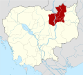
Cambodia, officially the Kingdom of Cambodia, is a country located in the southern portion of the Indochina peninsula in Southeast Asia. It is 181,035 square kilometres in area, bordered by Thailand to the northwest, Laos to the northeast, Vietnam to the east and the Gulf of Thailand to the southwest. The sovereign state of Cambodia has a population of over 16 million. The official religion is Theravada Buddhism, practised by approximately 95 percent of the population. The country's minority groups include Vietnamese, Chinese, Chams and 30 hill tribes. The capital and largest city is Phnom Penh, the political, economic and cultural centre of Cambodia. The kingdom is an elective constitutional monarchy with a monarch, currently Norodom Sihamoni, chosen by the Royal Throne Council as head of state. The head of government is the Prime Minister, currently Hun Sen, the longest serving non-royal leader in Southeast Asia, ruling Cambodia since 1985. In 802 AD, Jayavarman II declared himself king, uniting the warring Khmer princes of Chenla under the name "Kambuja". This marked the beginning of the Khmer Empire, which flourished for over 600 years, allowing successive kings to control and exert influence over much of Southeast Asia and accumulate immense power and wealth. The Indianised kingdom facilitated the spread of first Hinduism and then Buddhism to much of Southeast Asia and undertook many religious infrastructural projects throughout the region, including the construction of more than 1,000 temples and monuments in Angkor alone. Angkor Wat is the most famous of these structures and is designated as a World Heritage Site. After the fall of Angkor to Ayutthaya in the 15th century, a reduced and weakened Cambodia was then ruled as a vassal state by its neighbours. In 1863, Cambodia became a protectorate of France, which doubled the size of the country by reclaiming the north and west from Thailand.
Svay Chrom District is a district located in Svay Rieng Province, Cambodia. The district is subdivided into 17 khums and 168 phums. According to the 1998 census of Cambodia, it had a population of 129,573.
Romeas Haek District is a district located in Svay Rieng Province, Cambodia. The district is subdivided into 16 khums and 204 phums. According to the 1998 census of Cambodia, it had a population of 111,505.
Romdoul District is a district located in Svay Rieng Province, Cambodia. The district is subdivided into 10 khums and 78 phums. According to the 1998 census of Cambodia, it had a population of 49,384.
Svay Theab District is a district located in Svay Rieng Province, Cambodia. The district is subdivided into 11 khums and 86 phums. According to the 1998 census of Cambodia, it had a population of 59,650. Most people are farmers. Many villagers sent their teenage children to work in the factory in Phnom Penh.
Svay Rieng District is a district located in Svay Rieng Province, Cambodia. It surrounds the provincial capital city of Svay Rieng. According to the 1998 census of Cambodia, it had a population of 21,205.
Bathi District is a district located in Takéo Province, in southern Cambodia. According to the 1998 census of Cambodia, it had a population of 113,693.
Bourei Cholsar District is a district located in Takéo Province, in southern Cambodia. According to the 1998 census of Cambodia, it had a population of 24,460.
Kiri Vong District is a district located in Takéo Province, in southern Cambodia. According to the 1998 census of Cambodia, it had a population of 92,446.
Kaoh Andaet District is a district located in Takéo Province, in southern Cambodia. According to the 1998 census of Cambodia, it had a population of 45,650.
Prey Kabbas District is a district located in Takéo Province, in southern Cambodia. According to the 1998 census of Cambodia, it had a population of 85,880.
Samraŏng District is a district located in Takéo Province, in southern Cambodia. According to the 1998 census of Cambodia, it had a population of 101,455.
Doun Kaev District is a district located in Takéo Province, in southern Cambodia. According to the 1998 census of Cambodia, it had a population of 39,186.
Tram Kak District is a district located in Takéo Province, in southern Cambodia. According to the 1998 census of Cambodia, it had a population of 144,032.
Siem Bouk District is a district located in Stung Treng Province, in north-east Cambodia. According to the 1998 census of Cambodia, it had a population of 10,235.
Stung Treng District is a district located in Stung Treng Province, in north-east Cambodia. According to the 1998 census of Cambodia, it had a population of 24,493. The provincial capital Stung Treng town is located within the district.
Angkor Thom District is an administrative district of Siem Reap Province, in north western Cambodia. The main Angkor Wat monument and the ancient city of Angkor Thom are both located within the district. According to the 1998 census of Cambodia, it had a population of 17,750.
Chi Kraeng District is a district located in Siem Reap Province, in north-west Cambodia. According to the 1998 census of Cambodia, it had a population of 106,727.
Prasat Bakong District is a district located in Siem Reap Province, in north-west Cambodia. According to the 1998 census of Cambodia, it had a population of 54,129.
Sout Nikom District is a district of Siem Reap Province, in north western Cambodia. According to the 1998 census of Cambodia, it had a population of 90,080.
Svay Leu District is a district of Siem Reap Province, in north western Cambodia. According to the 1998 census of Cambodia, it had a population of 12,869.
This Cambodian location article is a stub. You can help Wikipedia by expanding it. |