Articles related to Cambodia and Cambodian culture include:

Banteay Meanchey is a province of Cambodia located in the far northwest. It borders the provinces of Oddar Meanchey to the north, Siem Reap to the east, Battambang to the south, and shares an international border with Thailand to the west. Its capital and largest city is Serei Saophoan.

Battambang is a province of Cambodia in the far northwest of the country. Bordering provinces are Banteay Meanchey to the north, Pursat to the east and south, Siem Reap to the northeast, and Pailin to the west. The northern and southern extremes of the province's western boundaries form part of the international border with Thailand. In addition, Tonlé Sap forms part of the northeastern boundary between Siem Reap and Pursat. Its capital and largest city is Battambang.

Siem Reap, officially Siemreap, is a province (khaet) of Cambodia. It borders the provinces of Oddar Meanchey to the north, Preah Vihear and Kampong Thom to the east, Battambang to the south, and Banteay Meanchey to the west. Its capital and largest city is Siem Reap.

Battambang is the capital of Battambang Province and the third largest city in Cambodia.

Siem Reap is the second-largest city of Cambodia, as well as the capital and largest city of Siem Reap Province in northwestern Cambodia.

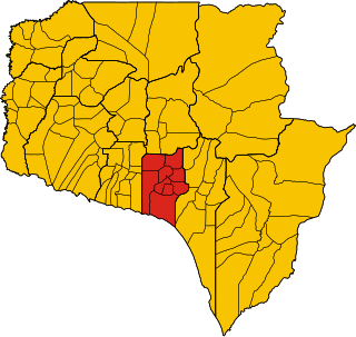
Mongkol Borey is a district (srok) in the south of Banteay Meanchey Province, in northwestern Cambodia. The district capital is the town of Mongkol Borey, around nine kilometres south of the provincial capital of Serei Saophoan by road. The district shares a border with Battambang Province to the south. The main railway line from Phnom Penh to Poipet on the border with Thailand runs through the district from north to south.

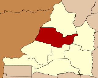
Preah Netr Preah is a district (srok) in the east of Banteay Meanchey province, in north-western Cambodia. The district capital is Preah Netr Preah town located around 24 kilometres (15 mi) due east of the provincial capital of Sisophon by road. Preah Netr Preah district is one of the easternmost districts of Banteay Meanchey. The district shares a border with both Siem Reap province and Battambang province to the east and the south respectively. Two major watercourses, the Sangke River and the Mongkol Borei River run through the district.

Serei Saophoan is a municipality (krong) in the centre of Banteay Meanchey province, in north-western Cambodia. Serei Saophoan is the urban district of Banteay Meanchey province and the district capital is also the provincial capital Sisophon town. The town is located 359 kilometres north of Phnom Penh and 48 kilometres from the border with Thailand at Poipet. Serei Saophoan municipality is the central municipality of Banteay Meanchey and is surrounded by other Banteay Meanchey districts. Cambodia's main railway line from Phnom Penh to Poipet enters the municipality from the south and exits to the west.

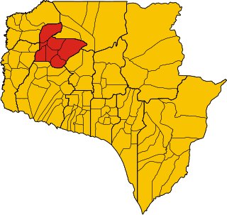
Thma Puok is a district (Srok) in the north of Banteay Meanchey province, in north-western Cambodia. The district capital is Thma Puok town located around 42 kilometres north of the provincial capital of Sisophon by road. The district shares a border with Thailand to the west and Oddar Meanchey province to the north east. No national highway runs through the district but national road 56 from Sisophon to Samraong in Oddar Meanchey province crosses the district from north to south. The district is home to the large temple complex of Banteay Chhmar. The temple was built in the late 12th or early 13th century by Jayavarman VII and is a modest tourist destination.
Svay Chek is a district (srok) in the north of Banteay Meanchey province, in north-western Cambodia. The district capital is Svay Chek town located around 22 kilometres north of the provincial capital of Sisophon by road. The district shares a border with Thailand to the west. No national highway runs through the district but national road 56 from Sisophon to Samraong in Oddar Meanchey province crosses the district from north to south.
Angkor Chum District is a district of Siem Reap Province, in north western Cambodia. According to the 1998 census of Cambodia, it had a population of 48,476.
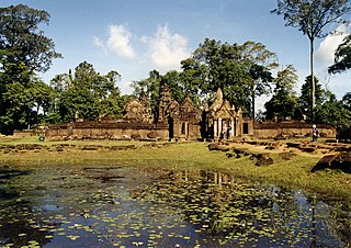
Banteay Srei is a district located in Siem Reap province, in north-west Cambodia. The temple of Banteay Srei is also located within the district. According to the 1998 census of Cambodia, it had a population of 32,271.
Prasat Bakong District Bakong District is a district located in Siem Reap Province, in north-west Cambodia. According to the 1998 census of Cambodia, it had a population of 54,129.
Roluos, also Phumi Roluos Chas, is a small town and khum (commune) of Svay Chek District in Banteay Meanchey Province in north-western Cambodia. It is located on road 56, 24km north of Sisophon.

Phnom Srok is a district (srok) in the east of Banteay Meanchey province, in north-western Cambodia. The district capital is Phnom Srok town located around 52 kilometres north east of the provincial capital of Sisophon by road. Phnom Srok district is the easternmost district of Banteay Meanchey. The district shares a border with both Siem Reap province and Oddar Meanchey province to the east. There are no major roads within the district and it is quite isolated.
Ang Trapeang ThmaProtected Landscape is a 126.50 km2 (48.84 sq mi) protected area in northwestern Cambodia that was first established in 1999 and converted to a protected landscape in 2016. The reserve was set aside to protect the rare eastern sarus crane. Prior to the discovery of the crane at Trapeang Thma, there were thought to be fewer than 1,000 of the birds left alive in the world.

Roluos is a Cambodian archeological site about 13 km east of Siem Reap along NH6. Once it was the seat of Hariharalaya, first capital of Khmer Empire north of Tonlé Sap.

Phibunsongkhram Province was a province of Thailand that existed between 1941 and 1946. It was created as a result of the annexation of Cambodian territory by Thailand following the 1940-41 Franco-Thai war. The province was named after Plaek Phibunsongkhram, prime minister of Thailand at the time. The province was dissolved and returned to France in 1946.
Chrouy Neang Nguon is a commune in Srei Snam district, Siem Reap Province, Cambodia. The estimated population in March 2019 was 7,713 people. The municipality covers an area of 77.45 km2 and has a population density of around 99.59 inhabitants per square kilometers.

