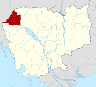
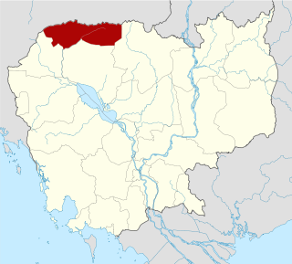
Banteay Meanchey is a province of Cambodia located in the far northwest. It borders the provinces of Oddar Meanchey to the north, Siem Reap to the east, Battambang to the south, and shares an international border with Thailand to the west. Its capital and largest city is Serei Saophoan.

Battambang is a province (khaet) of Cambodia in the far northwest of the country. Bordering provinces are Banteay Meanchey to the north, Pursat to the east and south, Siem Reap to the northeast, and Pailin to the west. The northern and southern extremes of the province's western boundaries form part of the international border with Thailand. In addition, Tonlé Sap forms part of the northeastern boundary between Siem Reap and Pursat. Its capital and largest city is Battambang.
Oddar Meanchey is a province of Cambodia in the remote northwest. It borders the provinces of Banteay Meanchey to the west, Siem Reap to the south and Preah Vihear to the east. Its long northern boundary demarcates part of Cambodia's international border with Thailand. The capital is Samraong.

Cambodia is divided into 25 provinces. The capital Phnom Penh is not a province but an "autonomous municipality", equivalent to a province governmentally and administered at the same level as the other 24 provinces.

Siem Reap is a province (khaet) of Cambodia. It borders the provinces of Oddar Meanchey to the north, Preah Vihear and Kampong Thom to the east, Battambang to the south, and Banteay Meanchey to the west. Its capital and largest city is Siem Reap.
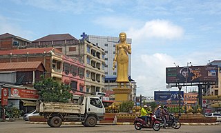
Poipet is a Cambodian boomtown on the Cambodia/Thailand border, in Poipet Municipality, Banteay Meanchey province. It is a key crossing point between the two countries, and also extremely popular as a gambling destination as gambling is popular, but illegal in Thailand.
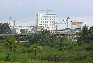
Serei Saophoan is the capital and largest city of the Banteay Meanchey Province and the fourth most populous city in Cambodia. The city separates Cambodia's National Highway 5 and National Highway 6. Its administrative name is "Serei Sophon" as used by the government. The more commonly used name Sisophon is derived from the Thai pronunciation Si Sophon when it was under the Thai rule. Another nickname "Svay" is used mainly by truck drivers, train drivers and workers transporting goods. The origin of the word "Svay" is unknown. Its population is 61,482 in the 1998 census, changing little to 61,631 in the 2008 census having been overtaken by Poipet in size.

Mongkol Borey is a district (srok) in the south of Banteay Meanchey province, in northwestern Cambodia. The district capital is Mongkol Borey town, around nine kilometres south of the provincial capital of Serei Saophoan by road. The district shares a border with Battambang province to the south. The main railway line from Phnom Penh to Poipet on the border with Thailand runs through the district from north to south.

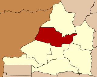
Preah Netr Preah is a district (srok) in the east of Banteay Meanchey province, in north-western Cambodia. The district capital is Preah Netr Preah town located around 24 kilometres due east of the provincial capital of Sisophon by road. Preah Netr Preah district is one of the easternmost districts of Banteay Meanchey. The district shares a border with both Siem Reap province and Battambang province to the east and the south respectively. Two major watercourses, the Sangke River and the Mongkol Borei River run through the district.

Ou Chrov is a district (srok) in the west of Banteay Meanchey province in north-western Cambodia. The border town of Poipet is located within the district. Poipet is the district capital and is located around 48.5 kilometres due west of the provincial capital of Sisophon by road. Ou Chrov district is one of the westernmost districts of Banteay Meanchey. The district borders on Thailand and Poipet contains a popular international border crossing which is home to numerous casinos.

Serei Saophoan is a municipality in the centre of Banteay Meanchey province, in north-western Cambodia. Serei Saophoan is the urban district of Banteay Meanchey province and the district capital is also the provincial capital Sisophon town. The town is located 359 kilometres north of Phnom Penh and 48 kilometres from the border with Thailand at Poipet. Serei Saophoan municipality is the central municipality of Banteay Meanchey and is surrounded by other Banteay Meanchey districts. Cambodia's main railway line from Phnom Penh to Poipet enters the municipality from the south and exits to the west.

Thma Puok is a district (Srok) in the north of Banteay Meanchey province, in north-western Cambodia. The district capital is Thma Puok town located around 42 kilometres north of the provincial capital of Sisophon by road. The district shares a border with Thailand to the west and Oddar Meanchey province to the north east. No national highway runs through the district but national road 56 from Sisophon to Samraong in Oddar Meanchey province crosses the district from north to south. The district is home to the large temple complex of Banteay Chhmar. The temple was built in the late 12th or early 13th century by Jayavarman VII and is a modest tourist destination.
Svay Chek is a district (srok) in the north of Banteay Meanchey province, in north-western Cambodia. The district capital is Svay Chek town located around 22 kilometres north of the provincial capital of Sisophon by road. The district shares a border with Thailand to the west. No national highway runs through the district but national road 56 from Sisophon to Samraong in Oddar Meanchey province crosses the district from north to south.

Malai is a district (srok) in the south west of Banteay Meanchey province, in north-western Cambodia. The district capital is Malai town located around 75 kilometres west of the provincial capital of Sisophon by road.
Banteay Ampil District is a district in Oddar Meanchey province in northern Cambodia. According to the 1998 census of Cambodia, it had a population of 27,075.
Prasat Bakong District is a district located in Siem Reap Province, in north-west Cambodia. According to the 1998 census of Cambodia, it had a population of 54,129.
Nimit is a sangkat of Poipet Municipality in Banteay Meanchey Province in north-western Cambodia. Before the establishment of Poipet Municipality, it was a khum of Ou Chrov District.
Kampong Chhnang municipality is a municipality in the centre of Kampong Chhnang province in central Cambodia. This is classed as an urban district and the provincial capital Kampong Chhnang City lies within the municipality. The district is quite small and encompasses the provincial town and nearby communes. Kampong Chhnang is the smallest district in Kampong Chhnang province and is surrounded by other Kampong Chhnang districts. The Tonle Sap river lies on the north and eastern borders of the district.

Phnom Srok is a district (srok) in the east of Banteay Meanchey province, in north-western Cambodia. The district capital is Phnom Srok town located around 52 kilometres north east of the provincial capital of Sisophon by road. Phnom Srok district is the easternmost district of Banteay Meanchey. The district shares a border with both Siem Reap province and Oddar Meanchey province to the east. There are no major roads within the district and it is quite isolated.
