Sla Kram ឃុំស្លក្រាម | |
|---|---|
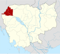
 Sla Kram Location within Cambodia | |
| Coordinates: 13°44′25″N102°57′41″E / 13.7402°N 102.9613°E | |
| Country | |
| Province | Banteay Meanchey |
| District | Svay Chek District |
| Villages | 10 |
| Time zone | UTC+07 |
| Geocode | 010803 |
Sla Kram is a khum (commune) of Svay Chek District in Banteay Meanchey Province in north-western Cambodia. [1]