Banteay Chhmar is an urban centre from the Angkorian period, situated in the northwest Cambodian province Banteay Meanchey, near to the Dangrek Mountains and the border of Thailand.[1]5 Thought to be a military centre or fortress, Banteay Chhmar is best-known for the sandstone temples, Bayon style and hydraulic system.[2]3[3]514[4]170 Recent research has produced a more complete understanding of the site, further exploring the role of Banteay Chhmar in the region. Developed by Jayavarman VII, Banteay Chhmar is a unique example of Angkorian urbanism, dissimilar to other 'open cities' of the period.[4]171 As a result, Banteay Chhmar has helped archaeologists to better understand Angkor, in particular, the rule of Jayavarman VII.
Under the rule of Jayavarman II, populations moved northward, creating centres in the north and northwest of Cambodia.[5]123-4 During the following Angkor period, Banteay Chhmar was created by Jayavarman VII and flourished between the 12th and 13th centuries C.E.[6]185[7]96 Jayavarman VII is one of the best-known Khmer rulers, described as expanding and unifying Angkor throughout his reign.[8]33 Reflecting Buddhist beliefs, Banteay Chhmar incorporates the Bayon style that was developed under Jayavarman VII. Unlike other urban centres, Banteay Chhmar was constructed in a regional, arid area and does not follow a formal grid-layout.[6]185[4]172 As a result, archaeologists are uncertain about the role of Banteay Chhmar, positing military, religious, political and medical purposes.[6]185[2]3
Contemporary research
During the late 20th century, archaeological research in Cambodia was halted by the Cambodian Civil War. The war limited access to, and intentionally damaged, many places of archaeological and heritage significance.[9]38 In the decades since, Cambodian and international archaeologists have worked to better understand the history of Cambodia, addressing issues of preservation, environmental management and colonial bias. The findings of colonial archaeologists continue to influence Cambodian history and heritage, upheld by problematic Orientalist perspectives.[6]43-8 However, contemporary archaeology is increasingly led by Cambodian archaeologists and the perspectives of Khmer people, producing new methods and interpretations.[6]56
The Cambodian Lidar Initiative (CALI) uses airborne laser scanning (ALS) to produce images of the Cambodian landscape, mapping anthropogenic change.[4]164 The integration of Geographic Information System (GIS) with ALS data, has mapped vast urban, agricultural and hydraulic networks.[4]165 In so doing, CALI has revealed new understandings of chronology, environment and residential life, which have been previously limited by issues of preservation.[4]164-5 ALS data can also infer population dynamics and movement, used by GIS to map the settlement patterns of Angkor.[10] This bares importance for a number of on-going debates within Cambodian archaeology, including urban systems, water management and the decline of Angkor.[4]172-4[11]12595 ALS has been applied to the site of Banteay Chhmar, providing insight into the development and use of the site.[4]170-1[1]
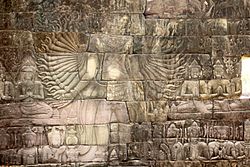
Site and structures
A temple and moat at Banteay Chhmar
Evidence of temples, stone structures and a hydraulic system can be found at Banteay Chhmar.
The temples at Banteay Chhmar follow the Bayon style of Jayavarman VII, named after the Buddhist state temple in Angkor Thom.[3]510 Banteay Chhmar consists of one primary temple with extended galleries and smaller, satellite temples.[12]3 Temples were laid in cardinal directions, invoking the Supreme Buddha at the centre of the mandala.[13]582-658 The mandala also came to represent political power, with one 'universal ruler' in control.[13]583 The temples were primarily constructed from sandstone, thought to have been quarried from Ta Phraya at the foothill of Mount Kulen.[12]14 The temples were then adorned with inscriptions, reliefs and statues, representing a number of religious and political ideas.
Jayavarman VII oversaw unprecedented urban expansion during his reign, in particular, developing ceremonial architecture.[3]514 Jayavarman VII promoted Mahayana Buddhism as the state religion, installing Buddhist and tantric imagery throughout Angkor.[6]486 Banteay Chhmar was part of this development, creating spaces where people could encounter the divine.[3]514 The temples at Banteay Chhmar display multiarmed Heruka dancing deities, alongside other tantric images such as Lokeśvara.[13]658-9[14]70 In addition, reliefs record chariots, horses, elephants and foot soldiers, describing systems of military power and transport.[15]446 Medical imagery is also present at the site, namely, carvings which denote a medicine blessing ceremony.[16]227 Given the location of Banteay Chhmar, archaeologists have suggested that the site was part of a medical network established by Jayavarman VII.[16]227
Unlike other 11th to 13th century C.E. temples, Banteay Chhmar did not follow a grid layout.[6]185[4]171 This was confirmed by recent ALS imagery of the site, which revealed 'almost no evidence of a formal urban grid.'[4]171 In contrast to the Angkorian model of urban development, there is little evidence of a central core, nor a successive urban complex.[6]185[4]171
Archaeologists have discovered an extensive hydraulic system which helped to manage water at the site. Banteay Chmmar was located in a dry, arid region which would have fallen victim to both draughts and floods.[4]171 As a result, water management was important to Banteay Chhmar, which developed a series of moats, channels, cannels, catchments and baray.[4][1] These served to store water during the dry season, as well as clear water during the wet season.[4]171 This system harnessed natural run-off and overflow, building slopes and channels to move water, as well as source water from the Dangrek Mountains.[1][2]4
Banteay Chhmar is uniquely constructed and located, raising questions about the purpose of the site. Archaeologists have developed several interpretations, the most prominent being a 'city' or 'garrison-temple' which was periodically inhabited.[4]185[2]4 In these renderings, Banteay Chhmar was an important religious, political or military centre, which played a role in cementing Angkorian power in the region.[6]185[2]4
Heritage
The archaeological complex of Banteay Chhmar is recognised by the UNESCO World Heritage Convention, praised for the water management system, temple complex and Buddhist motifs.[17] However, Banteay Chmmar – along with other Angkorian sites – has undergone significant destruction and looting in the past decades.[18]729[9]34-5 This has robbed the site of many valuable and portable features, including a number of reliefs and statues.[18]729-30[9]34-5 Many of these items remain lost, traded to vast market networks throughout Southeast Asia.[18]722
Tour of the Banteay Chhmar temple complex
Banteay Chhmar is also a place of significance to the local community, continuing to be used by the Cambodian people long after the Angkorian period.[17] The Global Heritage Fund and Heritage Watch have supported the local people in establishing community-based tourism.[19]206 This calls for tourism which supports the local economy, benefits built and social infrastructure and protects regional heritage and environments.[20]37-8 Community-based tourism aims to embed long-term and sustainable practices, often applied within remote contexts.[20]37-8 At Banteay Chhmar, The Global Heritage Fund and Provincial Government worked to provide education, training and support to the local community, seeking to expand tourism and preserve the site. Although the practice of community-based tourism is still developing, the project has begun to benefit heritage, tourism, business and infrastructure at Banteay Chhmar.[19]207-9[20]368-9[21]393-4
References
1234Evans D and Sanday J (2011) The Hydraulic System of Banteay Chhmar.
12345Sharrock P et al. (2015) Banteay Chhmar: garrison-temple of the Khmer empire, Bangkok, Thailand: River Books, 3.
1234Chemburkar S (2015) 'Dancing architecture at Angkor: 'Halls with dancers' in Jayavarman VII's temples', Journal of Southeast Asian studies (Singapore), 46 (3): 514–536.
123456789101112131415Evans D (2016) 'Airborne laser scanning as a method for exploring long-term socio-ecological dynamics in Cambodia', Journal of archaeological science, 74 (1): 164–175.
↑O'Reilly D (2006) Early Civilizations of Southeast Asia, Bloomsbury Publishing USA, New York.
123456789Hendrickson M, Stark M and Evans D (eds) (2023) The Angkorian World, Taylor & Francis Group, Oxford.
↑Dumarçay J and Royère P (2001) 'Architecture in the reign of Jayavarman VII. In: Cambodian Architecture', Eighth to Thirteenth Centuries, Leiden, Brill, 123–145.
↑Nietupski P (2019) 'Medieval Khmer Society: The Life and Times of Jayavarman VII (ca. 1120–1218)', ASIANetwork Exchange, 26 (1): 33–74.
123Miura K et al. (2016) 'Destruction and plunder of Cambodian cultural heritage and their consequences', in Cultural Property and Contested Ownership, United Kingdom, Routledge, 23–44.
↑Klassen S et al. (2021) 'Diachronic modeling of the population within the medieval Greater Angkor Region settlement complex', Science advances, 7 (19): 1-9.
↑Evans D et al. (2013) 'Uncovering archaeological landscapes at Angkor using lidar', Proceedings of the National Academy of Sciences - PNAS., 110 (31): 12595–12600.
12Uchida E et al. (2023) 'Non-destructive investigation of sandstone blocks used in the Wat Phu temple in Laos and the Banteay Chhmar temple in Cambodia', Heliyon, 9 (5): 1-15.
123Chemburkar, S. et al. (2024) 'Mandalas and Monarchs: Tantra and Temple Architecture in Buddhist Southeast Asia', in The Oxford Handbook of Tantric Studies. Oxford University Press, 581-678.
↑Green P (2014) 'The Many Faces of Lokeśvara: Tantric Connections in Cambodia and Campā between the Tenth and Thirteenth Centuries', History of religions, 54 (1): 69–93.
↑Hendrickson M (2011) 'A transport geographic perspective on travel and communication in Angkorian Southeast Asia (ninth to fifteenth centuries ad)', World archaeology, 43 (3): 444–457.
12Salguero C et al. (2017) Buddhism and Medicine: An Anthology of Premodern Sources, New York, Columbia University Press.
12UNESCO World Heritage Convention (2020) The Archaeological Complex of Banteay Chhmar, Tentative Lists, https://whc.unesco.org/en/tentativelists/6456/.
123Mackenzie S and Davis T (2014) 'TEMPLE LOOTING IN CAMBODIA: Anatomy of a Statue Trafficking Network', British journal of criminology, 54 (5): 722–740.
12O'Reilly D (2014) 'Heritage and Development: Lessons from Cambodia', Public Archaeology, 13 (1–3): 200–212.
123Schott C and Nhem S (2018) 'Paths to the market: analysing tourism distribution channels for community-based tourism', Tourism Recreation Research, 43 (3): 356–371.
↑Pawson S, D'Arcy P and Richardson S (2016) 'The value of community-based tourism in Banteay Chhmar, Cambodia', Tourism Geographies, 19 (3): 378–397.
Further reading
Bruno Bruguier, Olivier Cunin, Juliette Lacroix (2015). Banteay Chhmar et les provinces occidentales. Guide archéologique du Cambodge, Tome 3, JSRC. (ISBN 9-789924-900009)
Chapman W (2013) A heritage of ruins: the ancient sites of Southeast Asia and their conservation, Honolulu, University of Hawaii Press.
Cremin A (2009) 'Image and reality: Ceramics on Angkorian temple Reliefs in Cambodia', Australasian historical archaeology: journal of the Australasian Society for Historical Archaeology. 27 (1): 79–86.
Carter A et al. (2021) 'The evolution of agro-urbanism: A case study from Angkor, Cambodia', Journal of anthropological archaeology, 63 (1): 101323.
Evans D (2010) 'The Archaeological Landscape of Koh Ker, Northwest Cambodia', Bulletin de l'École française d'Extrême-Orient, 97 (1): 91–150, https://www.jstor.org/stable/43733235.
Evans D and Fletcher R (2015) 'The landscape of Angkor Wat redefined', Antiquity, 89 (348): 1402–1419.
Klassen S et al. (2018) 'Semi-supervised machine learning approaches for predicting the chronology of archaeological sites: A case study of temples from medieval Angkor, Cambodia', PloS one, 13 (11): 1-17.
Sharrock P (2007) 'The mystery of the Bayon face towers', in Clark J (ed.), Bayon: New Perspectives, Bangkok, River Books, 230–281.
Sharrock P et al. (2013) 'The Tantric Roots of the Buddhist Pantheon of Jayavarman VII', in Materializing Southeast Asia's Past. Singapore, NUS Press, 41-55.
This page is based on this Wikipedia article Text is available under the CC BY-SA 4.0 license; additional terms may apply. Images, videos and audio are available under their respective licenses.