Sisaket province is one of Thailand's seventy-six provinces (changwat). It lies in lower northeastern Thailand, a region called Isan. Neighboring provinces are : Surin, Roi Et, Yasothon, and Ubon Ratchathani. To the south it borders Oddar Meancheay and Preah Vihear of Cambodia.

Preah Vihear is a province (khaet) of Cambodia. It borders the provinces of Oddar Meanchey and Siem Reap to the west, Kampong Thom to the south and Stung Treng to the east. Its northern boundary forms part of Cambodia's international border with Thailand and Laos. Its capital is Preah Vihear.
Preah Vihear Temple is an ancient Hindu temple built by the Khmer Empire, located on top of a 525-metre (1,722 ft) cliff in the Dângrêk Mountains, in the Preah Vihear province of Cambodia.
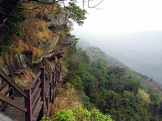
Khao Phra Wihan National Park is a protected natural area in Sisaket Province, Thailand, that contains numerous ruins of the 11th century Khmer Empire. The park lies 98 km (61 mi) south of the town of Sisaket, at the end of Thai highway 221. Sited on a red stone cliff that is part of the Dangrek mountain range on the southern edge of the Khorat Plateau, it abuts the international border between Thailand's Sisaket Province and Cambodia's Preah Vihear Province. The name of the cliff in the Royal Thai General System of Transcription is Pha Mo I Daeng (ผามออีแดง). The park was established on 20 March 1998, with an area of 81,250 rai ~ 130 square kilometres (50 sq mi).

Preah Vihear is the capital of Preah Vihear province in northern Cambodia. Phnom Tbeng Meanchey is the mountain rising to 600m 5 km south-west of Tbeng Meanchey town.
Khsach Kandal District is a district (srok) of Kandal Province, Cambodia. The district is subdivided into 18 communes (khum) such as Bak Dav, Chey Thum, Kampong Chamlang, Kaoh Chouram, Kaoh Oknha Tei, Preah Prasab, Preaek Ampil, Preaek Luong, Preaek Ta Kov, Preaek Ta Meak, Puk Ruessei, Roka Chonlueng, Sanlung, Sithor, Svay Chrum, Svay Romiet, Ta Aek, Vihear Suork and 93 villages (phum).
Ponhea Lueu District is a district (srok) of Kandal Province, Cambodia. The district is subdivided into 14 communes (khum) such as Chhveang, Chrey Loas, Kampong Luong, Kampong Os, Kaoh Chen, Phnum Bat, Ponhea Lueu, Ponhea Pon, Preaek Pnov, Preaek Ta Teaen, Phsar Daek, Samraong, Tumnob Thum, Vihear Luong and 141 villages (phum). In the northern part of the district, near the border between Kampong Speu and Kampong Chhnang is the old royal capital of Oudong.
Anlong Veng is a district (srok) in Oddar Meanchey province in Cambodia. The main town in the district is also called Anlong Veng. The population of the district could not be counted during the 1998 census of Cambodia due to ongoing conflict during the time of the census. It is estimated that 35% of the population in Anlong Veng were former Khmer Rouge soldiers including the Maoist dictator Pol Pot.
Chey Saen District is a district located in Preah Vihear Province, in northern Cambodia. According to the 1998 census of Cambodia, it had a population of 15,004. The population recorded by the 2008 census was 20,730.
Chhaeb District is a district located in Preah Vihear Province, in northern Cambodia. According to the 1998 census of Cambodia, it had a population of 12,450. The population recorded by the 2008 census was 16,731.
Kuleaen District is a district located in Preah Vihear Province, in northern Cambodia. According to the 1998 census of Cambodia, it had a population of 13,829. The population recorded by the 2008 census was 24,824.
Sangkum Thmei is a district located in Preah Vihear province, in northern Cambodia. According to the 1998 census of Cambodia, it had a population of 13,773.
Tbaeng Meanchey District is a district located in Preah Vihear Province, in northern Cambodia. According to the 1998 census of Cambodia, it consisted of six communes and had a population of 21,580. In 2008–2009, two communes—Kampong Pranak and Pal Hal—formed a new district, the Preah Vihear Municipality; according to the 2008 census, the population of the resulting four-commune district was 9,518.
Rovieng District is a district located in Preah Vihear Province, in northern Cambodia. According to the 1998 census of Cambodia, it had a population of 26,552.
Prey Kabbas District is a district located in Takeo Province, in southern Cambodia. According to the 1998 census of Cambodia, it had a population of 85,880.
Angkor Chum District is a district of Siem Reap Province, in north western Cambodia. According to the 1998 census of Cambodia, it had a population of 48,476.

The Cambodian–Thai border dispute began in June 2008 as part of a century-long dispute between the Kingdom of Cambodia and the Kingdom of Thailand involving the area surrounding the 11th-century Preah Vihear Temple, in the Dângrêk Mountains between Choam Khsant District, Preah Vihear Province of northern Cambodia and the Kantharalak District, Sisaket Province of northeastern Thailand.

Phnom Srok is a district (srok) in the east of Banteay Meanchey province, in north-western Cambodia. The district capital is Phnom Srok town located around 52 kilometres north east of the provincial capital of Sisophon by road. Phnom Srok district is the easternmost district of Banteay Meanchey. The district shares a border with both Siem Reap province and Oddar Meanchey province to the east. There are no major roads within the district and it is quite isolated.
Pal Hal is a village in Sangkat Pal Hal, Krong Preah Vihear (City).

Preah Vihear Municipality is a municipality located in Preah Vihear Province in northern Cambodia. The provincial capital Preah Vihear is located in the municipality.

