
Mean Chey is an administrative district (khan) located in the south-eastern part of Phnom Penh, Cambodia. As of 2019, due to boundary changes, its population decreased from 2008 but is the second most populous district of Phnom Penh.

Prey Chhor District is a district (srok) located in Kampong Cham Province, Cambodia. The district capital is Prey Totueng town located around 29 kilometres east of the provincial capital of Kampong Cham and 95 kilometres north west of Phnom Penh by road. Prey Chhor is a central district of Kampong Cham and is surrounded by other Kampong Cham districts.
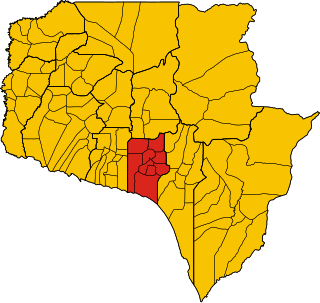
Srey Santhor District is a district (srok) located in Kampong Cham province, Cambodia. The district capital is Srey Santhor town located on the south bank of the Mekong River around midway between Phnom Penh and the provincial capital of Kampong Cham. Srey Santhor is in south western Kampong Cham and lies on the border with Kandal and Prey Veng provinces. It was briefly the capital of Cambodia during the post-Angkor era from 1431 to 1434. During the Middle Period, it was then known as Srey Sarchhor.
Ou Reang Ov District is a district (srok) located in Tboung Khmum Province, Cambodia. The district capital is Ou Reang Ov town located around 30 kilometres south of the provincial capital of Kampong Cham by road. Ou Reang Ov lies on the border where Tboung Khmum, Kampong Cham and Prey Veng provinces meet; the town of Prey Veng is only 42 kilometres away by road.

Batheay District is a district (srok) of Kampong Cham Province, Cambodia. The district capital is Ph'av town. The town is located on National Highway 6 around 64 kilometres east of the provincial capital at Kampong Cham city and 60 kilometres north of the Cambodian capital Phnom Penh. The district lies at the junction between two major waterways, the Mekong River and the Tonle Sap.
Samlout District is a district (srok) of Battambang Province, in north-western Cambodia.
Chol Kiri District is a district (srok) in the east of Kampong Chhnang Province, in central Cambodia. The district capital is Chol Kiri town located around 8 kilometres south of the provincial capital of Kampong Chhnang by road. Chol Kiri District is the easternmost district of Kampong Chhnang. The district shares a border with Kampong Thom and Kampong Cham provinces to the east. Most of the district is low lying floodplain and the Tonlé Sap river runs through the district roughly from north to south. This proximity to the river and the lack of high land make Chol Kiri one of the most flood prone districts in the country. The Kampong Chhnang Department of Development has estimated that both Chol Kiri and Kampong Leaeng districts are flooded for six months of the year and that after the floodwaters have receded drinking water sources are left contaminated.
Kampong Leaeng District is a district (srok) in the north east of Kampong Chhnang Province, in central Cambodia. The district capital is Kampong Leaeng town located around 4 kilometres east of the provincial capital of Kampong Chhnang in a direct line. Kampong Leaeng district is the northernmost district of Kampong Chhnang. The district shares a border with Kampong Thom province to north and east. Much of the district is low-lying floodplain and the Tonle Sap river runs through the district roughly from north to south. In the south of the district are two significant mountains. Phnom Chrak Tunling and Phnom Neang Kangrei both over 1000 metres in elevation.

Kampong Tralach District is a district (srok) in the south east of Kampong Chhnang Province, in central Cambodia. The district capital is Kampong Tralach town located 37 kilometres south of the provincial capital of Kampong Chhnang by road. The district shares a border with Kandal province to the south and Kampong Cham province to the east. The Tonle Sap river runs through the district crossing roughly from north to south.

Rolea B'ier District is a district (srok) in the center of Kampong Chhnang Province, in central Cambodia. The district capital is Rolea B'ier, a town located 5 kilometres south of the provincial capital of Kampong Chhnang. The district is surrounded by other Kampong Chhnang districts and in turn surrounds Kampong Chhnang District which includes the provincial capital. The Tonle Sap serves as the border of the district in the north east. The Kampong Chhnang Airport, built during the period of Democratic Kampuchea lies in Krang Leav commune.

Baray District is a district within Kampong Thom Province, in central Cambodia.
Snuol District (ស្នួល) is a district in Kratié Province, Cambodia. According to the 1998 census of Cambodia, it had a population of 35,156. The population recorded by the 2008 census was 61,603.
Chey Saen District is a district located in Preah Vihear Province, in northern Cambodia. According to the 1998 census of Cambodia, it had a population of 15,004. The population recorded by the 2008 census was 20,730.
Chhaeb District is a district located in Preah Vihear Province, in northern Cambodia. According to the 1998 census of Cambodia, it had a population of 12,450. The population recorded by the 2008 census was 16,731.
Tbaeng Meanchey District is a district located in Preah Vihear Province, in northern Cambodia. According to the 1998 census of Cambodia, it consisted of 6 communes and had a population of 21,580. In 2008–2009 two communes—Kampong Pranak and Pal Hal—formed a new district, the Preah Vihear Municipality; according to the 2008 census, the population of the resulting four-commune district was 9,518.
Pou Rieng District, formerly Kampong Leav District, is a district located in Prey Veng Province, in south-eastern Cambodia.
Prasat Bakong District is a district located in Siem Reap Province, in north-west Cambodia. According to the 1998 census of Cambodia, it had a population of 54,129.

Russey Keo, also spelled Russei Keo, is a district (khan) in the municipality of Phnom Penh, Cambodia. This district consists of the northern and north-eastern outskirts of the main city of Phnom Penh, stretching from Khan Sen Sok in the west to the Tonle Sap River in the east. As of 2019, it is the most populous district of Phnom Penh.

Pailin Municipality is a municipality (krong) in the centre of Pailin Province in north-western Cambodia. The municipality is subdivided into 4 communes (sangkat) and 36 villages (phum). According to the 1998/2008 census of Cambodia, the 575 km2 city had a population of 15,800 and 36,354 respectively.


