Pechora–Kama Canal

Last updated • 4 min readFrom Wikipedia, The Free Encyclopedia

The Pechora–Kama Canal (Russian : Канал Печора-Кама), or sometimes the Kama–Pechora Canal, was a proposed canal intended to link the basin of the Pechora River in the north of European Russia with the basin of the Kama, a tributary of the Volga. Completion of this project would integrate the Pechora into the system of waterways of European Russia, centered on the Volga – something that was of importance before the advent of railways, or before the first railway reached the Pechora in the 1940s. Later the project was proposed mostly to transfer Pechora's water to the Volga and further on to the Caspian Sea.

Contents

19th century proposals

In the 19th century, communication between the Kama and the Pechora was conducted mostly over a 40-km portage road between Cherdyn and Yaksha. There was also an option to use very small boats that could go up the uppermost reaches of Kama and Pechora tributaries, and cart the goods over the 4 km portage remaining. Poor river and road conditions made transportation into and out of the Pechora basin very expensive, and various improvement projects, including a narrow-gauge portage railroad were proposed. Nothing much was ever done, however.

20th century

A canal between the Pechora and the Kama was part of a plan for a "reconstruction of Volga and its basin", approved in November 1933 by a special conference of the USSR Academy of Sciences. Research in that direction was conducted by Hydroproject, the dam and canal institute led by Sergey Yakovlevich Zhuk (Russian : Сергей Яковлевич Жук ). Some design plans were developed by Zhuk's institute without much publicity or actual construction work. [1]

The canal plan was given new life in 1961 during Khrushchev's premiership. Now it was part of a grander scheme for "Northern river reversal", which also included similar river water diversion projects in Siberia.

Nuclear test

Unlike most other parts of the grand river rerouting scheme, the Pechora to Kama route did not just stay on the drawing board. It saw actual on-the-ground work done of the most unusual kind: on March 23, 1971, three 15-kiloton underground nuclear charges were exploded near the village of Vasyukovo in Cherdynsky District of Perm Oblast, some 100 km (62 mi) north of the town of Krasnovishersk. This nuclear test, known as Taiga, [2] part of the Soviet peaceful nuclear explosions program, was intended to demonstrate the feasibility of using nuclear explosions for canal construction. The triple blast created a crater over 600 m (2,000 ft) long. Later it was decided that building an entire canal in this fashion, using potentially several hundreds of nuclear charges, would not be feasible, and the use of nuclear charges for canal excavation was abandoned. [3] [4]

The Northern river reversal plan was completely abandoned by the government in 1986.

Environmental aftermath

Taiga crater
atomic lake
Ядерное озеро (Russian)
Relief Map of Perm Krai.svg
Red pog.svg
Taiga crater
Coordinates 61°18′21″N56°35′55″E / 61.30583°N 56.59861°E / 61.30583; 56.59861
Part ofPechora–Kama Canal
River sources Beryozovka River (Perm Krai)
BuiltMarch 23, 1971 (1971-03-23)
Max. length700 metres (2,300 ft)
Max. width350 metres (1,150 ft)

The Taiga explosions may be among the devices that produced the highest proportion of their yield via fusion-only reactions, with 98% of their 15 kiloton explosive yield being derived from fusion reactions, a total fission fraction of 0.3 kilotons in a 15 kt device. [5] [6] Such bombs are known as clean bombs, as it is fission that is responsible for generating radioactive fallout.

Around 2000, local environmentalists carried out several expeditions to the Taiga crater, and met the only person still residing in the Vasyukovo village. The fences surrounding the crater had rusted away and fallen down, and the "Atomic Lake" is now a popular fishing place for the residents of the other nearby villages, while its shores are known for the abundance of edible mushrooms. The area is also visited by the people who pick metal cables and other bits left over from the original test, to sell to scrap metal recycling businesses. The environmentalists recommended that the crater lake be fenced again, due to the continuing residual radioactivity. [7]

The triple "taiga" nuclear salvo test, part of the preliminary March 1971 Pechora–Kama Canal project, produced substantial amounts of relatively short-lived cobalt-60 from steel tubes and soil ("Origin of Co-60.Activation of stable Co, Fe, Ni (from the explosive device and the steel pipe, and from soil) by neutrons"). As of 2011, this fusion generated neutron activation product is responsible for about half of the gamma ray dose at the test site. Photosynthesizing vegetation exists all around the lake. A 2009 radiation survey of the lake and surrounding areas was conducted to determine the relative danger of the area, [8] [9] finding "the current external γ-ray dose rate to a human from the contaminations associated with the 'Taiga' experiment was between 9 and 70 μSv [micro-Sieverts] per week". The report also recommended periodic monitoring of the site. In comparison, typical exposure from naturally occurring background radiation is about 3mSv per year, or 57μSv per week. [10]

See also

Related Research Articles

A cobalt bomb is a type of "salted bomb": a nuclear weapon designed to produce enhanced amounts of radioactive fallout, intended to contaminate a large area with radioactive material, potentially for the purpose of radiological warfare, mutual assured destruction or as doomsday devices. There is no firm evidence that such a device has ever been built or tested.

<span class="mw-page-title-main">Nuclear weapon design</span> Process by which nuclear WMDs are designed and produced

Nuclear weapon designs are physical, chemical, and engineering arrangements that cause the physics package of a nuclear weapon to detonate. There are three existing basic design types:

<span class="mw-page-title-main">Project Plowshare</span> U.S. program examining the peaceful applications of nuclear explosives (1961–77)

Project Plowshare was the overall United States program for the development of techniques to use nuclear explosives for peaceful construction purposes. The program was organized in June 1957 as part of the worldwide Atoms for Peace efforts. As part of the program, 35 nuclear warheads were detonated in 27 separate tests. A similar program was carried out in the Soviet Union under the name Nuclear Explosions for the National Economy, although the Soviet program consisted of 124 tests.

<span class="mw-page-title-main">Operation Crosstie</span> Series of 1960s US nuclear tests

Operation Crosstie was a series of 48 nuclear tests conducted by the United States in 1967–1968 at the Nevada Test Site. These tests followed the Operation Latchkey series and preceded the Operation Bowline series.

<span class="mw-page-title-main">Kama (river)</span> River in Russia; Volga tributary

The Kama, also known as the Chulman, is a 1,805-kilometre (1,122 mi) long river in Russia. It has a drainage basin of 507,000 square kilometres (196,000 sq mi). It is the longest left tributary of the Volga and the largest one in discharge. At their confluence, in fact, the Kama is even larger in terms of discharge than the Volga.

<span class="mw-page-title-main">Project Chariot</span> 1958 proposal to use nukes to create an artificial harbor at Cape Thompson, Alaska

Project Chariot was a 1958 United States Atomic Energy Commission proposal to construct an artificial harbor at Cape Thompson on the North Slope of the U.S. state of Alaska by burying and detonating a string of nuclear devices.

<span class="mw-page-title-main">Operation Greenhouse</span> Series of 1950s US nuclear tests

Operation Greenhouse was the fifth American nuclear test series, the second conducted in 1951 and the first to test principles that would lead to developing thermonuclear weapons. Conducted at the new Pacific Proving Ground, on islands of the Enewetak Atoll, it mounted the devices on large steel towers to simulate air bursts. This series of nuclear weapons tests was preceded by Operation Ranger and succeeded by Operation Buster-Jangle.

<span class="mw-page-title-main">Pechora (river)</span> River in Northern Russia, sixth-longest in Europe

The Pechora is the sixth-longest river in Europe. Flowing from Northwest Russia and into the Arctic Ocean, it lies mostly in the Komi Republic but the northernmost part crosses the Nenets Autonomous Okrug.

<span class="mw-page-title-main">Chagan (nuclear test)</span> 1965 Soviet underground nuclear test

Chagan (Чага́н) was a Soviet underground nuclear test conducted at the Semipalatinsk Test Site on January 15, 1965.

<span class="mw-page-title-main">Sedan (nuclear test)</span> 1962 underground nuclear test at the Nevada Test Site

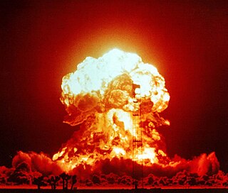
Storax Sedan was a shallow underground nuclear test conducted in Area 10 of Yucca Flat at the Nevada National Security Site on July 6, 1962, as part of Operation Plowshare, a program to investigate the use of nuclear weapons for mining, cratering, and other civilian purposes. The radioactive fallout from the test contaminated more US residents than any other nuclear test. The Sedan Crater is the largest human-made crater in the United States and is listed on the National Register of Historic Places.

<span class="mw-page-title-main">Shagan (lake)</span> Man-made lake in Kazakhstan created by a 1965 nuclear test

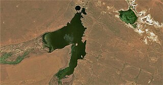
Shagan or Chagan is a lake in Zhanasemey District, Abai Region, Kazakhstan. Formed by a nuclear test explosion in 1965, it is part of the Balapan complex, one of the main tourist attractions of the Semipalatinsk Test Site.

Peaceful nuclear explosions (PNEs) are nuclear explosions conducted for non-military purposes. Proposed uses include excavation for the building of canals and harbours, electrical generation, the use of nuclear explosions to drive spacecraft, and as a form of wide-area fracking. PNEs were an area of some research from the late 1950s into the 1980s, primarily in the United States and Soviet Union.

<span class="mw-page-title-main">Ural (region)</span> Region of Russia

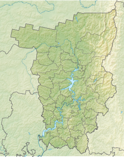
Ural is a geographical region located around the Ural Mountains, between the East European and West Siberian plains. It is considered a part of the Eurasian Steppe, extending approximately from the North to the South; from the Arctic Ocean to the end of the Ural River near Orsk city. The border between Europe and Asia runs along the Eastern side of the Ural Mountains. Ural mostly lies within Russia but also includes a small part of Northwestern Kazakhstan. This is historical, not an official entity, with borders overlapping its Western Volga and Eastern Siberia neighboring regions. At some point in the past, parts of the currently existing Ural region were considered a gateway to Siberia, or even Siberia itself, and were combined with the Volga administrative the divisions. Today, there are two official namesake entities: the Ural Federal District and the Ural economic region. While the latter follows the historical borders, the former is a political product; the District omits Western Ural and includes Western Siberia instead.

Nuclear Explosions for the National Economy was a Soviet program to investigate peaceful nuclear explosions (PNEs). It was analogous to the United States program Operation Plowshare, although the Soviet one consists of 124 tests.

<span class="mw-page-title-main">Nuclear explosion</span> Explosion from fission or fusion reaction

A nuclear explosion is an explosion that occurs as a result of the rapid release of energy from a high-speed nuclear reaction. The driving reaction may be nuclear fission or nuclear fusion or a multi-stage cascading combination of the two, though to date all fusion-based weapons have used a fission device to initiate fusion, and a pure fusion weapon remains a hypothetical device. Nuclear explosions are used in nuclear weapons and nuclear testing.

Yaksha (Якша) is a settlement in Troitsko-Pechorsky District of the Komi Republic, Russia, located in the upper streams of the Pechora River.

<span class="mw-page-title-main">Northern river reversal</span> Soviet Union project to divert the water resources of northern Siberia to Central Asia

The Northern river reversal or Siberian river reversal was an ambitious project to divert the flow of the Northern rivers in the Soviet Union, which "uselessly" drain into the Arctic Ocean, southwards towards the populated agricultural areas of Central Asia, which lack water.

A salted bomb is a nuclear weapon designed to function as a radiological weapon by producing larger quantities of radioactive fallout than unsalted nuclear arms. This fallout can render a large area uninhabitable. The term is derived both from the means of their manufacture, which involves the incorporation of additional elements to a standard atomic weapon, and from the expression "to salt the earth", meaning to render an area uninhabitable for generations. The idea originated with Hungarian-American physicist Leo Szilard, in February 1950. His intent was not to propose that such a weapon be built, but to show that nuclear weapon technology would soon reach the point where it could end human life on Earth.

<span class="mw-page-title-main">Yucca Flat</span> Nuclear test region in Nevada

Yucca Flat is a closed desert drainage basin, one of four major nuclear test regions within the Nevada Test Site (NTS), and is divided into nine test sections: Areas 1 through 4 and 6 through 10. Yucca Flat is located at the eastern edge of NTS, about ten miles (16 km) north of Frenchman Flat, and 65 miles (105 km) from Las Vegas, Nevada. Yucca Flat was the site for 739 nuclear tests – nearly four of every five tests carried out at the NTS.

<span class="mw-page-title-main">Northwest Russia</span> One of traditional regions of Russia

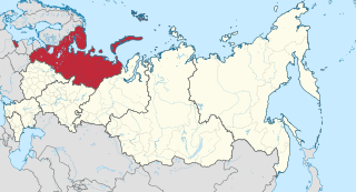
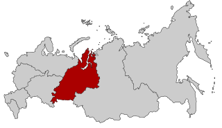
Northwest Russia, or the Russian North is the northern part of western Russia. It is bounded by Norway, Finland, the Arctic Ocean, the Ural Mountains and the east-flowing part of the Volga. The area is roughly coterminous with the Northwestern Federal District, which it is administered as part of. Historically, it was the area of the Novgorod and Pskov merchant republics.

References

  1. Weiner, Douglas R. (1999). A Little Corner of Freedom: Russian Nature Protection from Stalin to Gorbachev. University of California Press. p. 415. ISBN   0-520-23213-5.
  2. The Soviet Taiga PNE [ permanent dead link ]
  3. Soviet/Russian Nuclear Testing Summary
  4. Pavel Podvig, ed. (2004). Russian Strategic Nuclear Forces. MIT Press. p. 478. ISBN   0-262-66181-0.
  5. Disturbing the Universe – Freeman Dyson
  6. The Soviet Program for Peaceful Uses of Nuclear Explosions by Milo D. Nordyke. Science & Global Security, 1998, Volume 7, pp. 1–117. See test shot "Taiga".
  7. Атомный котлован (The Atomic Crater), Bellona, 25-Dec-2002
  8. Ramzaev, V.; Repin, V.; Medvedev, A.; Khramtsov, E.; Timofeeva, M.; Yakovlev, V. (2011). "Radiological investigations at the "Taiga" nuclear explosion site: Site description and in situ measurements". Journal of Environmental Radioactivity. 102 (7): 672–680. doi:10.1016/j.jenvrad.2011.04.003. PMID   21524834.
  9. Ramzaev, V.; Repin, V.; Medvedev, A.; Khramtsov, E.; Timofeeva, M.; Yakovlev, V. (2012). "Radiological investigations at the "Taiga" nuclear explosion site, part II: man-made γ-ray emitting radionuclides in the ground and the resultant kerma rate in air". Journal of Environmental Radioactivity. 109: 1–12. doi:10.1016/j.jenvrad.2011.12.009. PMID   22541991.
  10. "Naturally-occurring "background" radiation exposure". radiologyinfo.org. Retrieved 28 July 2016.