
Peggy's Cove is a small rural community located on the eastern shore of St. Margarets Bay in the Halifax Regional Municipality, which is the site of Peggys Cove Lighthouse.

St. Margarets Bay is a bay located on the Atlantic coast of Nova Scotia, Canada on the border of Halifax County and Lunenburg County.
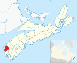
Clare, officially named the Municipality of the District of Clare, is a district municipality in western Nova Scotia, Canada. Statistics Canada classifies the district municipality as a municipal district.

The Shubenacadie Canal is a canal in central Nova Scotia, Canada. It links Halifax Harbour with the Bay of Fundy by way of the Shubenacadie River and Shubenacadie Grand Lake. Begun in 1826, it was not completed until 1861 and was closed in 1871. Currently small craft use the river and lakes, but only one lock is operational. Three of the nine locks have been restored to preserve their unique fusion of British and North American construction techniques. More extensive restoration is planned.
Richmond was a Canadian urban neighbourhood comprising part of the North End of the Halifax Peninsula in Nova Scotia's Halifax Regional Municipality.

The Halifax Regional Municipality has a number of parks and recreation areas in urban and rural settings.
The Lighthouse Route is a scenic roadway in the Canadian province of Nova Scotia. It follows the province's South Shore for 585 km (364 mi) from Halifax to Yarmouth.
Birch Cove is a subdivision and a cove in the community of Bedford within the Halifax Regional Municipality in Nova Scotia, Canada, on the shore of Bedford Basin and along the Bedford Highway. The name is after the birch trees that hung over the cove by William Donaldson, who named his estate Birch Cove.
Duncans Cove is a small rural community on the Chebucto Peninsula in the Halifax Regional Municipality on the shore of the Atlantic Ocean on the Ketch Harbour Road, 19 kilometers from Halifax. The community is located beside Chebucto Head, the prominent coastal headland.
Melville Cove is a residential subdivision in Armdale on Mainland Halifax within the Halifax Regional Municipality Nova Scotia on the shore of the Northwest Arm in Halifax Harbour.
Chebucto Head is a Canadian headland on Nova Scotia's Chebucto Peninsula located within the community of Duncan's Cove.

St. John's Anglican Church is a historic Carpenter Gothic style Anglican church building located at 8 Church Road in Peggys Cove, Nova Scotia, Canada. Built in 1893–94 of wood, St. John's is the only church in Peggys Cove. Its steep pitched roof, board and batten siding and lancet windows are typical of Carpenter Gothic churches. The church contains two murals painted in 1963 by noted Canadian artist and local resident William E. deGarthe.
Flat Lake could refer to the following lakes:
French Village is a rural community of the Halifax Regional Municipality in the Canadian province of Nova Scotia on Chebucto Peninsula. French village initially included present day villages of Tantallon, Glen Haven and French Village. The French that migrated to the area were French speaking families from the Principality of Montbeliard and known as the "Foreign Protestants". They had come to Nova Scotia between 1750 and 1752 to settle Lunenburg, Nova Scotia. Contrary to belief, they were not Huguenots. The church is the community is St. Paul's Church. In 1901, the Halifax and Southwestern Railway was built through the area and the railway choose the name French Village for the station serving the three communities. The French Village station, actually located in Tantallon, has been preserved as a cafe beside the recreational trail that follows the old Halifax & Southwestern Railway roadbed.
Indian Harbour is a small fishing community of the Halifax Regional Municipality in the Canadian province of Nova Scotia on the Chebucto Peninsula. It is located between the communities of Peggy's Cove and Hackett's Cove.

Hackett's Cove is a rural community of the Halifax Regional Municipality in the Canadian province of Nova Scotia on the Chebucto Peninsula.
Sandy Cove is a community of the Halifax Regional Municipality in the Canadian province of Nova Scotia on the Chebucto Peninsula.
Harrigan Cove is a rural community on the Eastern Shore of Nova Scotia, Canada, in the Halifax Regional Municipality. The community is located along the Marine Drive on Nova Scotia Trunk 7 about 25 km (16 mi) east of Sheet Harbour, Nova Scotia. The community is located in the vicinity the cove of the same name and is named for an early settler who came to the area after 1827.
Halibut Rock, just off the rocky shore of Peggy's Cove Point, Nova Scotia, is a navigation hazard, lying slightly below the surface. Extreme low tides sometimes offer a quick glimpse of its flat surface protruding above the trough of a swell. Most times cresting waves reveal its location, just southwest of the lighthouse. Halibut Rock is charted on the Nautical Chart of St. Margaret's Bay D7-4386.
Herring Cove is a Canadian suburban and former fishing community in Nova Scotia's Halifax Regional Municipality. It is situated on the eastern shore of the Chebucto Peninsula, 15 km (9.3 mi) south of Downtown Halifax. It is near the western approaches to Halifax Harbour, and can be reached both via Purcell's Cove along the coastal road and from inland via the Herring Cove Road through Spryfield. There are two schools in Herring Cove, William King Elementary and Herring Cove Junior High. The community is also home to a small variety of small businesses and programs.

