
The Port River is part of a tidal estuary located north of the Adelaide city centre in the Australian state of South Australia. It has been used as a shipping channel since the beginning of European settlement of South Australia in 1836, when Colonel Light selected the site to use as a port. Before colonisation, the Port River region and the estuary area were known as Yerta Bulti by the Kaurna people, and used extensively as a source of food and plant materials to fashion artefacts used in daily life.

Ethelton station is located on the Outer Harbor line. Situated in the north-western Adelaide suburb of Ethelton, it is 13.1 kilometres from Adelaide station. The station is currently closed for reconstruction.

Thebarton, formerly Theberton, on Kaurna land, is an inner-western suburb of Adelaide, South Australia in the City of West Torrens. The suburb is bounded by the River Torrens to the north, Port Road and Bonython Park to the east, Kintore Street to the south, and South Road to the west.
Regency Park is an inner-northern suburb of Adelaide, 6 km from the City Centre, in the state of South Australia, Australia. It is located in the City of Port Adelaide Enfield, and is adjacent to Wingfield, Angle Park, Ferryden Park, Kilburn, Prospect, Dudley Park and Croydon Park. It is bounded to the north by Grand Junction Road, east by the Gawler railway line, south by Regency Road and to the west by Days and South Roads. The postcode for Regency Park is 5010.
Outer Harbor is a suburb in the Australian state of South Australia located at the northern tip of the Lefevre Peninsula about 22 kilometres (14 mi) north-west of the Adelaide city centre.
Bowmans is a locality in South Australia's Mid North. At the 2006 census, Bowmans had a population of 203. It is named after R and C Bowman who were "pastoralists in area."
The Barker Inlet is a tidal inlet of the Gulf St Vincent in Adelaide, South Australia, named after Captain Collet Barker who first sighted it in 1831. It contains one of the southernmost mangrove forests in the world, a dolphin sanctuary, seagrass meadows and is an important fish and shellfish breeding ground. The inlet separates Torrens Island and Garden Island from the mainland to the east, and is characterised by a network of tidal creeks, artificially deepened channels, and wide mudflats. The extensive belt of mangroves are bordered by samphire saltmarsh flats and low-lying sand dunes.

The Adelaide Plains Council is a local government area in South Australia. It consists of a largely rural region along the Gulf St Vincent, covering a total area of approximately 926 km2. The council seat lies at Mallala, but it also maintains a service centre at Two Wells.
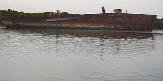
A ship graveyard or ship cemetery is a location where the hulls of scrapped ships are left to decay and disintegrate, or left in reserve. Such a practice is now less common due to waste regulations and so some dry docks where ships are broken are also known as ship graveyards.
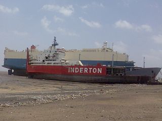
The Santiago was a 455-ton barque launched in 1856. It was built by Henry Balfour of Methil, Fife for the Liverpool shipping company Balfour Williamson. It sailed mainly between Liverpool and Chile, but also to Australia. Its remnant hull, which lies in a ships' graveyard in South Australia, was considered 'the oldest intact iron hull sailing vessel in the world', until part of the central section collapsed in January 2023.

Torrens Island is an island in the Australian state of South Australia located in the Adelaide metropolitan area in the Port River Estuary about 15 kilometres (9.3 mi) northwest of the Adelaide city centre. Since European settlement of Adelaide in 1836, it has been used for a number of purposes.

Oregon Pine was a six-masted lumber schooner completed in 1920, which was built as a result of the shipbuilding efforts associated with World War I. She sailed in the West Coast lumber trade, bringing lumber from the Columbia River to Shanghai and Port Adelaide, Australia.
Wooroora was an electoral district of the House of Assembly in the Australian colony of South Australia.
No 5 dumb hopper barge, since being scuttled known as the No. 5 Barge, Zanoni Barge and Ardrossan Barge, was a hopper barge which was built in 1911 at Balmain in New South Wales by Poole & Steel for the then Marine Board of South Australia, an agency of the Government of South Australia. She was part of a fleet of vessels used to dredge the shipping approaches to Port Adelaide and other ports in South Australia. Her specific role was to hold spoil from the dredging process and convey it under tow to a dumping site. In 1978, she became redundant after the purchase of two self-propelled barges.
Zanoni was a ship built in Liverpool, England in 1865 by W. H. Potter & Co as a 338-ton composite barque. It was owned by Thomas Royden & Sons who intended to use it for the East India trade.

Garden Island is an island in the Australian state of South Australia located about 14 kilometres (8.7 mi) north-west of the capital city of Adelaide in an estuary system within the Adelaide metropolitan area which drains into Gulf St Vincent. It is notable as being a site for a mangrove forest, a landfill, a part of the site for the Multifunction Polis, a ship graveyard and a venue for recreational boating activities. It has enjoyed varying degrees of protected area status since 1973.

The Stuart O'Grady Bikeway is a 23 kilometres (14 mi) shared path in the northern suburbs of Adelaide, following the eastern side of the Max Fatchen Expressway. The northeastern end is adjacent to the on ramp from Two Wells Road to the Gawler Bypass. The southwestern end is adjacent to Port Wakefield Road. It is named after Stuart O'Grady.
Conservation reserves of South Australia is a class of protected area used in the Australian state of South Australia where crown land under the control of the responsible minister has been dedicated for conservation purposes. This class of protected area has been in use as early as 1985. In 2016 there were 15 conservation reserves that covered an area of 194.7 square kilometres. As of March 2022 the number had increased to 16 conservation reserves covering 193.6 square kilometres or less than 1% of South Australia's land area.
Goyder is a locality in South Australia's Mid North situated in the central east of the cadastral Hundred of Goyder. It was named for the hundred which was in turn named for George Goyder, Surveyor General of South Australia at the time.
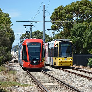
This article – one of several about Adelaide’s trams – describes the development of new lines and operation of new trams since 2005. Links to an overview and other articles are in the following panel.

