
Sierra de San Pedro Mártir is a mountain range located within southern Ensenada Municipality and southern Baja California state, of northwestern Mexico.

Sucre State is one of the 23 states of Venezuela. The state capital is Cumaná city. Sucre State covers a total surface area of 11,800 km2 (4,600 sq mi) and, as of the 2011 census, had a population of 896,921. The most important river in the state is the Manzanares River.
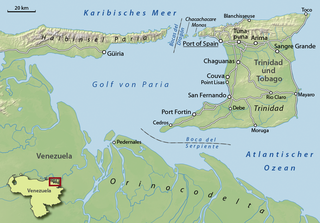
The Gulf of Paria is a 7,800 km2 (3,000 sq mi) shallow semi-enclosed inland sea located between the island of Trinidad and the east coast of Venezuela. It separates the two countries by as little as 15 km at its narrowest and 120 km at its widest points. The tides within the Gulf are semi-diurnal in nature with a range of approximately 1m. The Gulf of Paria is considered to be one of the best natural harbors on the Atlantic coast of the Americas. The jurisdiction of the Gulf of Paria is split between Trinidad and Tobago and Venezuela with Trinidad and Tobago having control over approximately 2,940 km2 (1,140 sq mi)(37.7%) and Venezuela the remainder(62.3%).

The Paria Peninsula,, is a large peninsula on the Caribbean Sea, in the state of Sucre in northern Venezuela.

The Venezuelan Coastal Range, also known as Venezuelan Caribbean Mountain System is a mountain range system and one of the eight natural regions of Venezuela, that runs along the central and eastern portions of Venezuela's northern coast. The range is a northeastern extension of the Andes, and is also known as the Maritime Andes. It covers around 48,866 km2, being the 4th largest natural region in Venezuela.

Bahía Portete – Kaurrele National Natural Park is a national natural park in Uribia, La Guajira, Colombia. The northernmost national park of mainland South America is located at the Caribbean coast of the La Guajira peninsula in Bahía Portete, between Cabo de la Vela and Punta Gallinas. Established on December 20, 2014, it is the most recently designated national park of the country. As of 2017, 59 nationally defined protected areas are incorporated in Colombia. The park hosts a high number of marine and terrestrial species.
The Rosario and San Bernardo Corals National Natural Park is a natural park located in the Sucre and Bolívar Departments on the coast of the Caribbean Region of Colombia, 45 km from the Bay of Cartagena. It was the most visited national park in Colombia in 2009, with 318,473 visitors.

The Eastern Region is one of the 10 administrative regions in which Venezuela was divided for its development plans; it comprises the states of Anzoátegui, Monagas, and Sucre.

The El Guache National Park Is a protected area with the status of national park in Venezuela, located at the beginning of the Andes mountain range, comprising mountainous parts of the Lara and Portuguesa states, and the birth of the Guache, Ospino, Toco, Morador and Are rivers. 2 In its adjacencies is the mighty waterfall San Miguel. It has an area of 12,200 ha traditionally measured and 15,960 Ha. Its temperature is between 19 °C. and 26 °C. Precipitation varies between 1800 and 2000 mm annually.
The Río Viejo San Camilo National Park Also Rio Viejo-San Camilo National Park Is a protected area with the status of national park in the South American country of Venezuela. Specifically its territory is part of the state of Apure near the border with Colombia. It has an estimated area of 80,000 hectares, which constitute national park since 1 July 1993.

The Turuépano National Park Is a protected area with national park status in the South American country of Venezuela, located in the Benítez, Cajigal, Libertador and Mariño municipalities in the eastern part of Sucre State, north of the San Juan River and in front of the Gulf of Paria.

The Sierra La Culata National Park Also Sierra de la Culata National Park is a national park of Venezuela that is located in the northeastern branch of the Venezuelan Andes, in the states Mérida and Trujillo. It was decreed a national park on December 7, 1989. It has a high mountain climate, with temperatures ranging between −2 and 24 °C, and its surface area is 200,400 hectares (774 sq mi).
The Chorro El Indio National Park Is a national park of Venezuela located to the east of San Cristóbal, Táchira State, in the mountain range the Maravilla, has access by the highway San Cristóbal - Macanillo - Potosí.

The General Juan Pablo Peñaloza National Park Also Páramos Batallón y La Negra National Park Is a national park of Venezuela that is formed by several páramos: Among them Batallón and La Negra, which are an important source of water supply. It is located between the states Mérida and Táchira, northwest of the Táchira depression in the Páramos de El Batallón and La Negra in Venezuela.

The El Tamá National Park It is a protected area with the status of a national park that is located between the Andes and plains of Venezuela. It protects part of the Tamá Massif. It has an area of 139,000 hectares and is located in the states of Táchira and Apure, near the border with Colombia. Created as a National Park on December 12, 1978, by the then President Carlos Andrés Pérez.

The Cerro El Copey National Park Also Cerro El Copey-Jóvito Villalba National Park Is a protected area with the status of a national park located to the east of the Caribbean island of Margarita, in the highest mountainous region of Nueva Esparta State in Venezuela. It was created in 1974 with the purpose of protecting an outstanding physiographic feature with an ecosystem that includes several plant formations, high levels of endemism and the only permanent water sources of the island.

The Laguna de Tacarigua National Park Also Tacarigua Lagoon National Park Is a protected area with the status of a national park located east of Miranda State, in the South American country of Venezuela. It comprises a permanent coastal lagoon of 7800 ha and 1.2 m of average depth, separated from the sea by a restinga or coastal barrier of 28.8 km long and 300–1000 m wide that was formed by the action of the sea current Which runs along the coast in an East-West direction.
The Abra de Río Frío Natural Monument Is a protected natural space located in the municipality of San Cristóbal, in the state of Táchira, Venezuela. Received the status of natural monument on February 18, 1993.

The Araya and Paria xeric scrub (NT1301) is an ecoregion in Venezuela that stretches along the Caribbean coast to the west of Trinidad, and that includes Margarita Island and some smaller islands. The ecoregion includes dune herbs, dry thorn scrubs and deciduous forests. The mountains on Margarita Island hold montane forests similar to those in the mainland coastal range. The beaches are used for breeding by sea turtles. Some endemic bird species are threatened with extinction by illegal capture for the pet trade. Deforestation and over-grazing by goats are also problems.


