Peraliya

Last updated
Peraliya
Sri Lanka adm-2 location map.svg
Red pog.svg
Peraliya
Location in Sri Lanka
Coordinates: 6°8′50″N80°6′37″E / 6.14722°N 80.11028°E / 6.14722; 80.11028
CountryFlag of Sri Lanka.svg  Sri Lanka
Province Southern Province
District Galle District
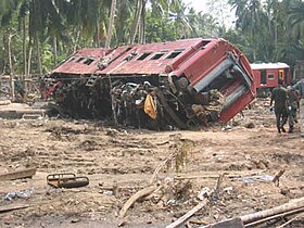
2004 Sri Lanka tsunami-rail disaster Sri-lanka-train-04jan-2004.jpg
2004 Sri Lanka tsunami-rail disaster

Peraliya is a small coastal village situated in Hikkaduwa, Galle District in the Southern Province of Sri Lanka.

The village could be reached from Colombo in three hours; it is located around Temple Road off the 95 km mark of Galle Road. [1]

The village was devastated by the tsunami at around 9.26 am on December 26, 2004 following the Indian Ocean earthquake. An express train from Colombo towards Galle swept away killing at least 1,700 passengers. The village had lost 500 of its people, and 200 have gone missing. [1]

Related Research Articles

<span class="mw-page-title-main">Colombo</span> Capital and largest city of Sri Lanka

Colombo is the executive and judicial capital and largest city of Sri Lanka by population. According to the Brookings Institution, the Colombo metropolitan area has a population of 5.6 million, and 752,993 in the Municipality. It is the financial centre of the island and a tourist destination. It is located on the west coast of the island and adjacent to the Greater Colombo area which includes Sri Jayawardenepura Kotte, the legislative capital of Sri Lanka, and Dehiwala-Mount Lavinia. Colombo is often referred to as the capital since Sri Jayawardenepura Kotte is itself within the urban/suburban area of Colombo. It is also the administrative capital of the Western Province and the district capital of Colombo District. Colombo is a busy and vibrant city with a mixture of modern life, colonial buildings and monuments.

<span class="mw-page-title-main">Galle</span> City in Southern Province, Sri Lanka

Galle is a major city in Sri Lanka, situated on the southwestern tip, 119 km (74 mi) from Colombo. Galle is the provincial capital and largest city of Southern Province, Sri Lanka and is the capital of Galle District.

<span class="mw-page-title-main">Southern Province, Sri Lanka</span> Province of Sri Lanka

The Southern Province of Sri Lanka is one of the nine provinces of Sri Lanka, the first level administrative division of the country. The provinces have existed since the 19th century but did not have any legal status until 1987 when the 13th Amendment to the Constitution of Sri Lanka established provincial councils. It is the 7th largest province by area and is home to 2.5 million people, the 3rd most populated province. The province is bordered by Sabaragamuwa Province and Uva Province to the North, Eastern Province to the Northeast, Western Province to the Northwest and the Indian Ocean to the South, West and East. The Province's capital is Galle.

<span class="mw-page-title-main">2004 Sri Lanka tsunami train wreck</span> Largest rail disaster

The 2004 Sri Lanka tsunami train wreck is the largest single rail disaster in world history by death toll, with 1,700 fatalities or more. It occurred when a crowded passenger train was destroyed on a coastal railway in Sri Lanka by a tsunami that followed the 2004 Indian Ocean earthquake. The tsunami subsequently caused over 30,000 reported deaths and billions of rupees in property damage in the coastal areas of Sri Lanka.

<span class="mw-page-title-main">Effect of the 2004 Indian Ocean earthquake on Sri Lanka</span>

Sri Lanka was one of the countries struck by the tsunami resulting from the Indian Ocean earthquake on December 26, 2004. On January 3, 2005, Sri Lankan authorities reported 30,000+ confirmed deaths.

<span class="mw-page-title-main">National Maritime Museum (Galle)</span>

The National Maritime Museum or National Maritime Archaeology Museum in Galle, Sri Lanka is situated within Galle Fort. It was first opened to the public on 9 May 1992 and is located in a 1671 Dutch Warehouse above the Old Gate of Galle Fort. Whilst the building housing the museum survived the impact of the 26 December 2004 tsunami, the adjoining UNESCO Maritime Archaeology Unit was completely destroyed and all the exhibitions were flood damaged and the majority of maritime archeological artifacts were lost. Under Sri Lanka – Netherlands Cultural Co-operation Program, the Royal Government of Netherlands provided financial assistance for reconstruction of the Maritime Museum. After 3 years period of reconstruction, the Maritime Museum was re-opened to the public.

Amarasiri Dodangoda was a Sri Lankan politician, the former Minister of Justice and Law Reforms (2005–2009) and the second Chief Minister of the Southern Province (1993–1994).

<span class="mw-page-title-main">Hikkaduwa</span> Place in Sri Lanka

Hikkaduwa is a coastal town in Galle district of Sri Lanka. Hikkaduwa is a major tourist attraction in Sri Lanka and is known for its beaches and corals. It is located in the Southern Province, about 17 km (11 mi) north-west of Galle and 98 km (61 mi) south of Colombo. Despite significant development in the last decade it is still home to the endangered and endemic purple-faced langur, an usually shy monkey species that can only be found in Sri Lanka's forests. It is divided into three main areas that are : the Sri Lankan village, the tourist area, and then Thiranagama.

<span class="mw-page-title-main">Sri Lanka Railways</span> Sri Lankan government-owned railway

The Sri Lanka Railway Department is Sri Lanka's railway owner and primary operator. As part of the Sri Lankan government, it is overseen by the Ministry of Transport. Founded in 1858 as the Ceylon Government Railway, it operates the nation's railways and links Colombo with other population centres and tourist destinations.

<span class="mw-page-title-main">Aluthgama</span> Town in Sri Lanka

Aluthgama is a coastal town in Kalutara District in the Western Province of Sri Lanka. It is approximately 63.5 kilometres (39.5 mi) south of Colombo and 68 kilometres (42 mi) north of Galle. Aluthgama is situated on the southern bank of the Bentota Ganga (River) mouth.

Ahangama is a suburb of Galle. It is located within the Principality of Ruhuna, Sri Lanka, Southern Province. It is located approximately 19.2 km (11.9 mi) away from the Galle within Galle District of the Southern Province. It is situated on the boundary of Galle District and Matara District. It is a major centre which connects Matara District with Galle District. It is a major suburb on the A02 highway, after Galle. It is a major centre on the road for the vehicles and long distance buses run on the route. Ahangama is surrounded by towns such as Habaraduwa, Koggala, Weligama and Imaduwa.

<span class="mw-page-title-main">Galle Fort</span> Historic military fortress in Sri Lanka

Galle Fort, in the Bay of Galle on the southwest coast of Sri Lanka, was built first in 1588 by the Portuguese, then extensively fortified by the Dutch during the 17th century from 1649 onwards. It is a historical, archaeological and architectural heritage monument, which even after more than 432 years maintains a polished appearance, due to extensive reconstruction work done by Archaeological Department of Sri Lanka.

<span class="mw-page-title-main">Coastal line (Sri Lanka)</span>

The coastal line is a major railway line in Sri Lanka, running between Colombo Fort and Beliatta, via Galle and Matara. Operated by Sri Lanka Railways, the line includes some of the busiest rail services in the country. The line has been extended to Beliatta on 8 April 2019 and is proposed to be extended to Kataragama, via Hambantota. With a designed maximum speed of 100 km/h (62 mph) between Kalutara and Matara, and a maximum speed of 120 km/h (75 mph) between Matara and Beliatta, the line is one of the fastest in Sri Lanka.

<span class="mw-page-title-main">Koggala</span> Town in Southern Province, Sri Lanka

Koggala is a small coastal town, situated at the edge of a lagoon on the south coast of Sri Lanka, located in Galle District, Southern Province, Sri Lanka, governed by an Urban Council. Koggala is bounded on one side by a reef, and on the other by a large lake, Koggala Lake, into which the numerous tributaries of the Koggala Oya drain. It is approximately 139 kilometres (86 mi) south of Colombo and is situated at an elevation of 3 metres (9.8 ft) above the sea level.

Ahungalla is a small coastal town, located in Galle District, Southern Province, Sri Lanka, governed by an Urban Council. It is approximately 76.6 kilometres (47.6 mi) south of Colombo and is situated at an elevation of 12 metres (39 ft) above the sea level.

Boossa is a small town on the south coast of Sri Lanka, located in the Galle District of the Southern Province. It is approximately 123 kilometres (76 mi) south of Colombo and 12 kilometres (7.5 mi) north of Galle, immediately north of the mouth of the Gin Gaga. It is situated at an elevation of 5 metres (16 ft) above the sea level.

<span class="mw-page-title-main">Groote Kerk, Galle</span>

The Groote Kerk or Dutch Reformed Church is located within the Galle fort in Galle, Sri Lanka and is situated near the entrance to the fort. The church was built by the Dutch in 1755 and is one of the oldest Protestant churches still in use in the country.

<span class="mw-page-title-main">Rekawa Lagoon</span> Lagoon in Hambantota District, Sri Lanka

Rekawa Lagoon is a coastal waterbody located in Hambantota Districtt in the Southern Province, Sri Lanka and it is located 200 km (120 mi) south of Colombo. The lagoon possesses a rich biodiversity with a variety of flora and fauna.

Isuru Udyoga Dodangoda is a Sri Lankan politician, former provincial councillor and Member of Parliament.

References

  1. 1 2 "Peraliya Village and the Peraliya Mission statement". www.peraliya.com. Retrieved 29 December 2014.

See also