Red Mesa is a census-designated place (CDP) in Apache County, Arizona, United States. The population was 480 at the 2010 census.

St. Jacob is a village in Madison County, Illinois, United States. The population was 1098 at the 2010 census.
Lookout Mountain is a town in Hamilton County, Tennessee, United States. The population was 1,832 at the 2010 census. It is part of the Chattanooga, TN–GA Metropolitan Statistical Area.
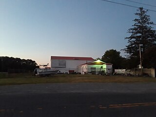
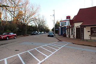
Keller is a town in Accomack County, Virginia, United States. The population was 178 at the 2010 census.
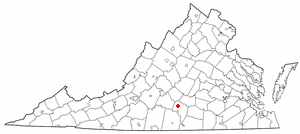
Phenix is a town in Charlotte County, Virginia, United States. The population was 226 at the 2010 census.
Nishikanbara is a district located in Niigata Prefecture, Japan.

Sturgis is a town of 620 people in east central Saskatchewan, Canada. The Town of Sturgis is 95 km north of Yorkton on Highway 9. It is located in the Assiniboine river valley near the lakes and woods region of the province.

Sâniob is a commune in Bihor County, western Romania. The village was named after Stephen I of Hungary's Holy Dexter - his preserved right hand which was kept in an abbey here. The name was granted by Ladislaus I of Hungary in 1083. It was conquered by the Ottomans in 1661, becoming the seat of a sanjak in Varat Eyalet. Called Şenköy by the new authorities, it was captured by the Habsburg Monarchy in 1691.
Koromilea is a village located in the central, mountainous area of Messenia, Greece. It is a settlement of 70 inhabitants, administratively belonging to the municipal unit Trikorfo. The main occupation of the inhabitants, historically, is livestock and mixed farming.
Offa is one of the woredas in the Southern Nations, Nationalities, and Peoples' Region of Ethiopia. Part of the Wolayita Zone, Offa is bordered on the south by the Gamo Gofa Zone, on the west by Kindo Didaye, on the north by Kindo Koysha, on the northeast by Sodo Zuria, and on the east by Humbo. The administrative center of Offa is Gesuba. Western part of Offa was added to Kindo Didaye woreda.
Athikia is a village in the regional unit of Corinthia in Greece. It was the seat of the former municipality of Saronikos. Athikia has a population of 2,038 and is located 15 km South of the city of Corinth.

Mount Vernon Township is one of sixteen townships in Jefferson County, Illinois, USA. As of the 2010 census, its population was 13,374 and it contained 6,422 housing units.
Foieni is a commune of 1,836 inhabitants situated in Satu Mare County, Romania. It is composed of a single village, Foieni.
Platanorrevma is a village located alongside the Pieria Mountains in Servia municipal unit, Kozani regional unit, in the Greek region of Macedonia. It is situated at an altitude of 490 meters. The postal code is 50500, while the telephone code is +30 24640. At the 2011 census the population was 1,004.
Imera is a community in Servia municipal unit, Kozani regional unit, in the Greek region of Macedonia. It consists of the settlements Imera and Avra. The village Imera is situated at an altitude of 352 meters above sea level. The postal code is 50100, while the telephone code is +30 24640. At the 2011 census the population was 212.

Alirajpur is one of the 52 districts of Madhya Pradesh state in India. It was created from Alirajpur, Jobat and Bhabra tehsils of the former Jhabua district on 17 May 2008. It is the least literate district in India as per Census 2011. Alirajpur is the administrative headquarters of the district. The district occupies an area of 2,165.24 square kilometres (836.00 sq mi), and at the 2011 census had a population of 728,677.

Dhakuria is a census town in Gaighata CD Block in Bangaon subdivision in North 24 Parganas district in the state of West Bengal, India.

Planitero is a mountain village in the municipal unit of Kleitoria, Achaea, Greece. It is situated in the southwestern part of the Chelmos (Aroania) mountains. Its population is 197 people. Its elevation is 700 m. Planiteri is 1.5 km north of Armpounas, 6 km northeast of Kleitoria and 12 km southeast of Kalavryta. The source of the river Aroanios is near Planitero.

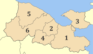
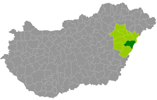
Püspökladány is a district in south-western part of Hajdú-Bihar County. Püspökladány is also the name of the town where the district seat is found. The district is located in the Northern Great Plain Statistical Region. This district is a part of Hajdúság historical and geographical region.
Derecske is a district in central-eastern part of Hajdú-Bihar County. Derecske is also the name of the town where the district seat is found. The district is located in the Northern Great Plain Statistical Region.