Related Research Articles

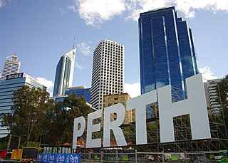
Perth is the capital and largest city of Western Australia. It is the fourth most populous city in Australia and Oceania, with a population of over 2.2 million within Greater Perth. It is part of the South West Land Division of Western Australia, with the majority of Perth's metropolitan area on the Swan Coastal Plain between the Indian Ocean and the Darling Scarp. The city has expanded outward from the original British settlements on the Swan River, upon which its central business district and port of Fremantle are situated.

Arthurs Seat is a mountainous and small locality on the Mornington Peninsula in Melbourne, Victoria, Australia, about 85 km south east of Melbourne's Central Business District, located within the Shire of Mornington Peninsula local government area. Arthurs Seat recorded a population of 414 at the 2021 census.

The Joondalup line is a commuter rail service in Western Australia, linking the Perth central business district (CBD) with the metropolitan area's north-western suburbs. The service is operated on the Northern Suburbs Railway by Transperth Train Operations, a division of the Public Transport Authority, and is part of the Transperth network. It is 40.7 kilometres (25.3 mi) long and serves 13 stations. The service is currently being extended to Yanchep as part of the Yanchep Rail Extension project.

The Mandurah line is a commuter railway and service on the Transperth network in Western Australia that runs from Perth south to the state's second largest city Mandurah. The service is operated by Transperth Train Operations, a division of the Public Transport Authority. The line is 70.1 kilometres (43.6 mi) long and has 12 stations. At its northern end, the line begins as a continuation of the Joondalup line at Perth Underground, and ends as a continuation of the Joondalup line at Elizabeth Quay. The first 1.3 kilometres (0.81 mi) of the line is underground, passing under the Perth central business district. The line surfaces and enters the median of the Kwinana Freeway just north of the Swan River. It continues south down the freeway's median for 30 kilometres (19 mi), before veering south-west towards Rockingham. The final stretch of the line goes south from Rockingham to Mandurah.
The Swan Bells are a set of 18 bells hanging in a specially built 82.5-metre-high (271 ft) copper and glass campanile in Perth, Western Australia. The tower is commonly known as The Bell Tower or the Swan Bell Tower.

Kings Park, is a 399.9-hectare (988-acre) park overlooking Perth Water and the central business district of Perth, Western Australia.
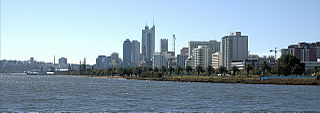
Perth Water is a section of the Swan River on the southern edge of the central business district of Perth, Western Australia. It is between the Causeway to the east, and Narrows Bridge to the west – a large wide but shallow section of river, and the northern edge of the suburb South Perth. It is considered a landmark of the City of Perth.

The Perth Convention and Exhibition Centre is a privately owned convention centre located in Perth, Western Australia.

The City of Perth is a local government area and body, within the Perth metropolitan area, which is the capital of Western Australia. The local government is commonly known as Perth City Council. The City covers the Perth city centre and surrounding suburbs. The City covers an area of 20.01 square kilometres (8 sq mi) and had an estimated population of 21,092 as at 30 June 2015. On 1 July 2016 the City expanded, absorbing 1,247 residents from the City of Subiaco.

The Ningaloo Coast is a World Heritage Site located in the north west coastal region of Western Australia. The 705,015-hectare (1,742,130-acre) heritage-listed area is located approximately 1,200 kilometres (750 mi) north of Perth, along the East Indian Ocean. The distinctive Ningaloo Reef that fringes the Ningaloo Coast is 260 kilometres (160 mi) long and is Australia's largest fringing coral reef and the only large reef positioned very close to a landmass. The Muiron Islands and Cape Farquhar are within this coastal zone.
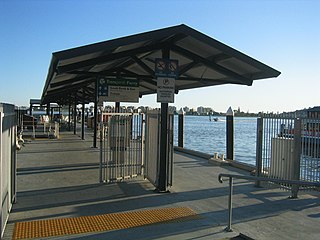
Barrack Street Jetty is located on the edge of Perth Water on the Swan River in Perth, Western Australia. It is no longer used on the Transperth ferry service between the Perth central business district and South Perth, having been replaced on that service with Elizabeth Quay Jetty.

Brookfield Place is a skyscraper within the Brookfield Place office complex in Perth, Western Australia. It is currently the second tallest building in Western Australia. Located at 125 St Georges Terrace, the major tenant is BHP.

Perth is a suburb in the Perth metropolitan region, Western Australia that includes both the central business district of the city, and a suburban area spreading north to the northern side of Hyde Park. It does not include the separate suburbs of Northbridge or Highgate. Perth is split between the City of Perth and the City of Vincent local authorities, and was named after the city of the same name in Scotland.
East Bayfront LRT, also known as the Waterfront East LRT, is a planned Toronto streetcar line that would serve the East Bayfront and Port Lands areas in Toronto, Ontario, Canada. It would run from Union station under Bay Street and along Queens Quay and Cherry Street to a new Villiers Loop along Commissioners Street east of Cherry Street on Villiers Island. It would complement the existing 509 Harbourfront service that connects Union Station to Queens Quay west of Bay Street. Longer-term plans are to extend the East Bayfront line from Cherry and Commissioners Streets to the planned East Harbour Transit Hub along GO Transit's Lakeshore East line and the planned Ontario Line.
The Esplanade Reserve in Perth, Western Australia, was a heritage listed public space between Perth Water and the Perth central business district. The public space was resumed by the Western Australian state government in April 2012 as part of the Elizabeth Quay redevelopment of the Perth waterfront area.

The north shore of Perth Water on the Swan River frontage to the city of Perth in Western Australia has been frequently changed since the arrival of Europeans in 1829. Various forms and structures have appeared and been removed over the last 190 years. Jetties, ports and various forms of reclamation have moved the shore considerably into Perth Water. The main eras of reclamation were in the 1870s, 1900s, 1920s-1937, 1955–1959, and 1967.

Riverside Drive in Perth, Western Australia, is a road on the northern side of Perth Water. It was built on reclaimed land in the 1930s, and links The Causeway to the Narrows Bridge.

Elizabeth Quay is a mixed-use development project in the Perth central business district. Encompassing an area located on the north shore of Perth Water near the landmark Swan Bells, the precinct was named in honour of Queen Elizabeth II during her Diamond Jubilee.
References
- 1 2 3 "Cable car the key to tourism". Yahoo! News. 24 March 2014. Retrieved 24 January 2015.
- ↑ "Investigations underway into Elizabeth Quay-Kings Park cable car". PerthNow. 29 June 2014. Retrieved 24 January 2015.
- ↑ "The designs and ideas behind Perth's new waterfront". Australian Broadcasting Corporation. 16 February 2011. Retrieved 24 January 2015.
- ↑ "Destination Perth - Developing Perth's Visitor Economy" (PDF). WA Tourism Council. March 2013. Archived from the original (PDF) on 28 January 2015. Retrieved 24 January 2015.
- ↑ "A Cable Car (Gondola) for Perth, Australia?". The Gondola Project. 16 February 2011. Retrieved 24 January 2015.