
The Santa Ana River is the largest river entirely within Southern California in the United States. It rises in the San Bernardino Mountains and flows for most of its length through San Bernardino and Riverside counties, before cutting through the northern Santa Ana Mountains via Santa Ana Canyon and flowing southwest through urban Orange County to drain into the Pacific Ocean. The Santa Ana River is 96 miles (154 km) long, and its drainage basin is 2,650 square miles (6,900 km2) in size.
The San Diego Creek bicycle path is a cycling route in the city of Irvine, California. The path connects major points such as Newport Beach, University of California, Irvine, Boomers Irvine, Colonel Bill Barber Park, Irvine Civic Center, Irvine Crossroads shopping center, Woodbridge High School, Woodbridge Community Park, Atria Senior Residential Area, Windrow Community Park and Irvine Medical Complex, before reaching Irvine Spectrum Center. It also runs through the majority of Irvine's neighborhoods such as Westpark, Woodbridge, and Oak Creek. The path begins where the San Diego Creek empties into Upper Newport Bay.

Irvine is a master-planned city in southern Orange County, California, United States, in the Los Angeles metropolitan area. The Irvine Company started developing the area in the 1960s and the city was formally incorporated on December 28, 1971. The 66-square-mile (170 km2) city had a population of 307,670 at the 2020 census; it is the 63rd most populous city in the United States.
California's 40th congressional district is a congressional district in the U.S. state of California, encompassing Orange, San Bernardino, and Riverside counties. The district is currently represented by Republican Young Kim. It was one of 18 districts that would have voted for Joe Biden in the 2020 presidential election had they existed in their current configuration while being won or held by a Republican in 2022.

Jamboree Road is a 15.8-mile (25.4 km) long major arterial road through Orange County, California, running through the cities of Newport Beach, Irvine, Tustin, and Orange.
Rancho Santiago de Santa Ana was a 63,414-acre (256.63 km2) Spanish land concession in present-day Orange County, California, given by Spanish Alta California Governor José Joaquín de Arrillaga in 1810 to Jose Antonio Yorba and his nephew Pablo Peralta. The grant extended eastward from the Santa Ana River to the Santa Ana Mountains, with a length of more than 22 miles (35 km).

Aliso Creek is a 19.8-mile (31.9 km)-long, mostly urban stream in south Orange County, California. Originating in the Cleveland National Forest in the Santa Ana Mountains, it flows generally southwest and empties into the Pacific Ocean at Laguna Beach. The creek's watershed drains 34.9 square miles (90 km2), and it is joined by seven main tributaries. As of 2018, the watershed had a population of 144,000 divided among seven incorporated cities.

Aliso and Wood Canyons Wilderness Park is a major regional park in the San Joaquin Hills of Orange County, California in the United States. Comprising 4,500 acres (1,800 ha) of rugged coastal canyons, open grassland, and riparian woodland, the park borders the suburban cities of Aliso Viejo, Dana Point, Laguna Beach, Laguna Hills and Laguna Niguel and lies within a portion of the ancestral homeland of the indigenous Acjachemen people.

Santiago Creek is a major watercourse in Orange County in the U.S. state of California. About 34 miles (55 km) long, it drains most of the northern Santa Ana Mountains and is a tributary to the Santa Ana River. It is one of the longest watercourses entirely within the county. The creek shares its name with Santiago Peak, at 5,687 ft (1,733 m) the highest point in Orange County, on whose slopes its headwaters rise.

Laguna Canyon, also called Cañada de las Lagunas, is a gorge that cuts through the San Joaquin Hills in southern Orange County, California, in the United States, directly south of the city of Irvine. The canyon runs from northeast to southwest, and is drained on the north side by tributaries of San Diego Creek and on the south by Laguna Canyon Creek. It is deeper and more rugged on the southwestern end near Laguna Beach.

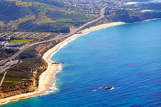
San Diego Creek is a 16-mile (26 km) urban waterway flowing into Upper Newport Bay in Orange County, California in the United States. Its watershed covers 112.2 square miles (291 km2) in parts of eight cities, including Irvine, Tustin, and Costa Mesa. From its headwaters in Laguna Woods the creek flows northwest to its confluence with Peters Canyon Wash, where it turns abruptly southwest towards the bay. Most of the creek has been converted to a concrete flood control channel, but it also provides important aquatic and riparian habitat along its course and its tidal estuary.
Rancho Lomas de Santiago was a 47,227-acre (191 km2) Mexican land grant given by Mexican Governor Pío Pico to Teodosio Yorba in 1846. The name means "Hills of St. James". The rancho included parts of present-day Irvine and Tustin in what is now eastern Orange County, California.

Sulphur Creek is a 4.5-mile (7.2 km) tributary of Aliso Creek in Orange County in the U.S. state of California. The creek drains about 6 square miles (16 km2) of residential communities and parks in the southern San Joaquin Hills.

Peters Canyon Wash is a tributary of San Diego Creek in central Orange County in the U.S. state of California. About 11.8 miles (19.0 km) long north-south, the wash, now mostly channelized, flows in a relatively straight course southwest from the 55-acre (0.22 km2) Peters Canyon Reservoir near the Orange/Tustin borderline to its confluence with San Diego Creek near the Irvine Civic Center Plaza. Less than 5 miles (8.0 km) below this confluence, San Diego Creek empties into Upper Newport Bay. The largest tributary of Peters Canyon is the Santa Ana Channel
Sand Canyon Wash is an approximately 6.9-mile (11.1 km) tributary of San Diego Creek in Orange County, southern California.

Laguna Coast Wilderness Park is a 7,000-acre (2,800 ha) wilderness area in the San Joaquin Hills surrounding Laguna Beach, California. This park features coastal canyons, ridgeline views and the only natural lakes in Orange County, California. Trails are maintained for hiking and mountain biking with a wide range of difficulty, from beginner to expert. Most trails gain in height, reaching a maximum of 1,000 feet (300 m) in elevation. Several trails lead to downtown Laguna Beach.
The Irvine Ranch Natural Landmarks are a collection of protected areas in Orange County, California in and around Irvine. They encompass almost 50,000 acres (20,000 ha) of land which was once a part of the Irvine Ranch owned by the Irvine Company. Almost 40,000 acres (16,000 ha) of the landmarks were designated a National Natural Landmark in 2006 and a California Natural Landmark in 2008.

Whiting Ranch Wilderness Park is a public regional park in southern Orange County, California. Whiting Ranch features riparian, oak woodland, grassland, chaparral, and coastal sage scrub environments throughout various canyons and hillscapes. The 2,500-acre park mostly encompasses unincorporated land just outside of Lake Forest. The park is home to over 17 miles of trail spread out over 23 different paths, making the location a popular destination for mountain bikers, hikers, and horseback riders.
Orange County Parks, more commonly abbreviated to OC Parks, is a government agency that maintains and oversees the public parks of Orange County, California. The agency operates both natural and manmade parks of the region. OC Parks is responsible for 60,000 acres (24,000 ha) of inland and coastal open space that collectively receives millions of visitors every year.


 A scenic view of Peters Canyon, photo taken in March 1966.
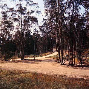 Peters Canyon Road, surrounded by eucalyptus trees, in April 1966.
 Peters Canyon Reservoir today.


