
A brick is a type of construction material used to build walls, pavements and other elements in masonry construction. Properly, the term brick denotes a unit primarily composed of clay, but is now also used informally to denote units made of other materials or other chemically cured construction blocks. Bricks can be joined using mortar, adhesives or by interlocking. Bricks are usually produced at brickworks in numerous classes, types, materials, and sizes which vary with region, and are produced in bulk quantities.

A road surface or pavement is the durable surface material laid down on an area intended to sustain vehicular or foot traffic, such as a road or walkway. In the past, gravel road surfaces, macadam, hoggin, cobblestone and granite setts were extensively used, but these have mostly been replaced by asphalt or concrete laid on a compacted base course. Asphalt mixtures have been used in pavement construction since the beginning of the 20th century and are of two types: metalled (hard-surfaced) and unmetalled roads. Metalled roadways are made to sustain vehicular load and so are usually made on frequently used roads. Unmetalled roads, also known as gravel roads or dirt roads, are rough and can sustain less weight. Road surfaces are frequently marked to guide traffic.

Balboa Island is a harborside community in Newport Beach, California, accessible to the public via bridge, ferry and several public docks. The community is surrounded by a paved concrete boardwalk open to pedestrian traffic, designated as a public walking trail by the city.

Cobblestone is a natural building material based on cobble-sized stones, and is used for pavement roads, streets, and buildings.

A paver is a paving stone, tile, brick or brick-like piece of concrete commonly used as exterior flooring. They are generally placed on top of a foundation which is made of layers of compacted stone and sand. The pavers are placed in the desired pattern and the space between pavers is then filled with a polymeric sand. No actual adhesive or retaining method is used other than the weight of the paver itself except edging. Pavers can be used to make roads, driveways, patios, walkways and other outdoor platforms.

Crescent Hill is a neighborhood four miles (6 km) east of downtown Louisville, Kentucky USA. This area was originally called "Beargrass" because it sits on a ridge between two forks of Beargrass Creek. The boundaries of Crescent Hill are N Ewing Ave to the St. Matthews city limit by Brownsboro Road to Lexington Road. Frankfort Avenue generally bisects the neighborhood.

Neighborhoods in Spokane, Washington are officially grouped by the Spokane City Council into three main city council districts: 1, 2, and 3. Each city council district contains multiple, official neighborhoods that are recognized with a neighborhood council. Informally, neighborhoods are colloquially grouped by local geographical, geological, cultural, or historical features The list of neighborhoods below is organized based on the official designations by the City of Spokane. Unofficial neighborhoods and districts are listed within the official neighborhood in which they are located.

State Route 41 (SR 41) is a 134.5-mile-long (216.5 km) state highway that runs south-to-north through portions of Calhoun, Randolph, Terrell, Webster, Marion, Talbot, Meriwether, and Coweta counties in the southwestern and west-central parts of the U.S. state of Georgia. The route connects the Morgan area to Moreland, via Buena Vista, Manchester, Warm Springs, and Greenville.

Transportation in Tulsa, Oklahoma includes a bus network and a system of raised highways and primary thoroughfares, laid out in mile-by-mile increments. In addition, throughout its entire length in Tulsa, historic Route 66 is a drivable road, with motels and restaurants reminiscent of the route's heyday era.

The Nathan G. Moore House, also known as the Moore-Dugal Residence, is a house designed by Frank Lloyd Wright. The house was built one block south of Wright's home and studio at 333 Forest Avenue in the Chicago suburb of Oak Park, Illinois. It was originally completed in 1895 in the Tudor Revival style at the request of client Nathan Moore. Wright obliged his client's wishes, but long after disliked the house for its adherence to historical styles.
Joe Creason Park is a municipal park in Louisville, Kentucky, United States. Located in the Poplar Level neighborhood, it is in roughly the central portion of the city. The park adjoins and connects to Beargrass Creek State Nature Preserve, and both were originally part of the same property prior to becoming parks.

Court Avenue is a small street in downtown Bellefontaine, Ohio, United States, located adjacent to the Logan County Courthouse. First paved in 1893, it is known for being the first street in the United States to be paved with concrete.
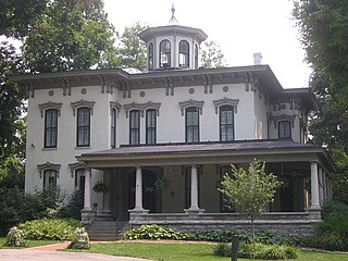
The Peterson–Dumesnil House is a Victorian-Italianate house in the Crescent Hill neighborhood of Louisville, Kentucky, United States. Of the remaining large country estates built by Louisvillians in the late 19th century to the east of the city, it is the closest to Downtown Louisville, and primarily for that reason, it was added to the National Register of Historic Places in 1975.

A sett, also known as a block or Belgian block, is a broadly rectangular quarried stone used in paving roads and walkways. Formerly in widespread use, particularly on steeper streets because setts provided horses' hooves with better grip than a smooth surface, they are now encountered rather as decorative stone paving in landscape architecture. Setts are often referred to as "cobblestones", although a sett is distinct from a cobblestone in that it is quarried or worked to a regular shape, whereas the latter is generally a small, naturally-rounded rock. Setts are usually made of granite.
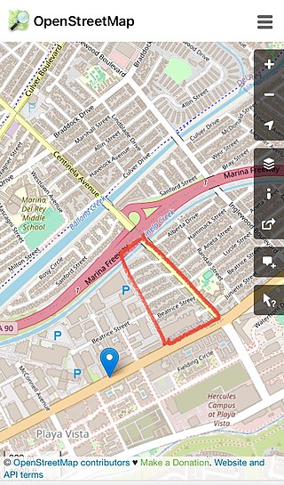
Alsace is a place name designating what was originally an interurban trolley stop, and now an approximately five-block enclave of unincorporated Los Angeles County in the Westside region, surrounded by Del Rey, just north of the Playa Vista neighborhood of Los Angeles, California, United States.
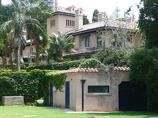
Boomerang is a heritage-listed private house and garden located at 42 Billyard Avenue in the inner eastern Sydney suburb of Elizabeth Bay, in the City of Sydney local government area of New South Wales, Australia. The house was designed by Neville Hampson and the gardens and grounds by Max Shelley, and built from 1926 to 1928.
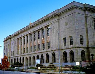
The Ed Edmondson United States Courthouse, previously called the Muskogee Federal Building- United States Courthouse, is a historic government building in Muskogee, Oklahoma. It was built in 1915 as a post office and federal courthouse. Although it is no longer used as a post office, it is currently in use by several government offices, including the U.S. Marshals and U.S. Probation Office as well as the United States District Court for the Eastern District of Oklahoma.
Alberhill is an unincorporated community in Riverside County, California. Alberhill is located 5.5 miles (8.9 km) northwest of Lake Elsinore. It lies at an elevation of 1234 feet. Alberhill was named after C.H. Albers and James and George Hill.
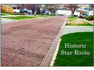
The Star Route and Palouse Street Brick Road, in Pullman, Washington, also known by the nickname Red Brick Roads are a block of NE Maple St. and a block of NE Palouse St. and together are the last remaining brick streets in the city. In the early 2010s, students in WSU's School of Design & Construction researched the history and significance of the brick roads. The course project led to listings on the Pullman Register of Historic Places and the National Register of Historic Places in 2014. The roads, paved in 1913, are important landmarks because of their connection with the Good Roads Movement. They made transportation easier along the only of the city's Star routes, providing an essential connection between the Northern Pacific Railroad depot and the growing campus of Washington State College. The steepest part of the route to campus received brick paving to provide traction for horses and automobiles—particularly during the difficult winter months.
The Triple Palace, also known as the William H. Vanderbilt House, was an elaborate mansion at 640 Fifth Avenue between 51st Street and 52nd Street in Midtown Manhattan, New York City. The urban mansion, completed in 1882 to designs by John B. Snook and Charles B. Atwood, was owned by members of the Vanderbilt family. It was composed of two portions: a single-family unit to the south and a two-family unit to the north. William Henry Vanderbilt owned and lived in the southern portion. Two of his daughters, Emily Thorn Vanderbilt and Margaret Louisa Vanderbilt Shepard, along with their respective families, occupied the two residences in the northern portion.


