Sagareshwar Wildlife Sanctuary is a protected area in the Indian state of Maharashtra. It is located at the meeting of three Tehsils of Sangli district: Kadegaon, Walva and Palus. The wildlife sanctuary is man-made; it is an artificially cultivated forest without a perennial supply of water, and most of the wildlife species were artificially introduced. It has an area of 10.87 km².

Kirloskarwadi is an industrial township that developed around the Kirloskar Brothers Ltd factory in the Sangli district, in Maharashtra state, India. It is the second oldest industrial township in India. On 10 March 2010, Kirloskarwadi celebrated 100 years of its establishment. Kirloskarwadi is a rapidly growing satellite suburb of Sangli city. The famous holy place of God Datta Maharaj Audumbar is just 10 km away. While Sagareshwar picnic spot is around 8–10 km away. Another famous holy place Audumbar of the god Datta Maharaj is just about 11 km from this place. The town has centric connectivity between Vita–Isalmapur–Palus–Tasgaon takulas.

Miraj Senior was one of two Maratha princely states during the British Raj: 'Miraj Junior' and Miraj Senior. The two states separated in 1820. It was under the southern division of the Bombay Presidency, forming part of the southern Mahratta Jagirs, and later the Deccan States Agency.
Tasgaonpronunciation (help·info) is a city and a municipal council in Sangli district in the Indian state of Maharashtra. Tasgaon was given as Jahagir to Parshuram Bhau Tasgaonkar by Narayan Ballal Peshava in 1774. Tasgaon sansthan was lapsed by British during ruling of Shrimant Ganapatrao Tasgaonkar. Tasgaon Grapes from the city from Tasgaon are famous grapes in Maharashtra. Tasgaon has rapidly merged with Sangli city as a satellite suburb and will soon become part of Sangali Urban Agglomeration.

Chandoli National Park is a National Park spread over Satara, Kolhapur and Sangli District, Maharashtra State, India, established in May 2004. Earlier it was a Wildlife Sanctuary declared in 1985. Chandoli Park is notable as the southern portion of the Sahyadri Tiger Reserve, with Koyna Wildlife Sanctuary forming the northern part of the reserve
Shirol is a historic place also. It was named "Shirol", because there is story behind it. The story is:"there was great war between the Great Shivaji Maharaj & Mughal’s. In that war mughals were defeated & the heads of cruel Mughal soldiers were hanged to main gate of city. So the name Shirol: Shir(heads) + ol(row).
Ashta is a town and a municipal council in Sangli district in the state of Maharashtra, India. It is located at 16.95°N 74.4°E. It has an average elevation of 567 metres (1860 ft). The name "Ashta" comes from the legend that Lord Shri Ram established eight (Asht) Lord Mahadev temples in this area. The city is divided into 19 wards for which elections are held every 5 years. The Ashta Municipal Council has the population of 37,105 of which 19,171 are males while 17,934 are females as per the report released by Census India 2011.
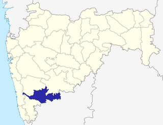
Walwa is a town and a tehsil in Sangli district in the Indian state of Maharashtra. It is also known as Valva-Islampur Taluka. There are ninety-five panchayat villages in Walwa Taluka.
Kadegaon is a city and taluka of Sangli district of Maharashtra in India. About kadegaon-
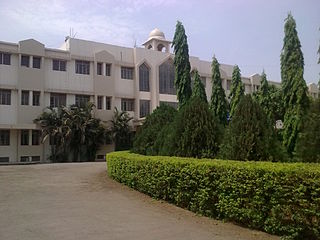
Adarsh Balak Mandir High School is a school in the locality of Islampur in Sangli district, Maharashtra, India. It was established in 1945 by D. L. Ramname, who was a freedom fighter. Previously it was at Gandhi Chowk, Islampur, but then it was shifted to the Sambhaji Chowk area by the late Hon. Pralhad Hari Deshpande.

Diggewadi is a village in Raybag taluk in Belgaum Panchayat in the southern state of Karnataka, India. The official language of Diggewadi is Kannada.

Sangli State was one of the 11-gun salute Maratha princely states of British India. It was under the Kolhapur-Dekkan Residency in the Bombay Presidency, and later the Deccan States Agency.
Bhood is a village in Khanapur tehsil of Sangli district in Maharashtra, India. It is located near the city Vita.
Annasaheb Dange College of Engineering & Technology (ADCET) is an engineering education institute in the city of Ashta in the Indian state of Maharashtra. It is located about 20 km from Sangli. The ADCET campus is situated on nearly 32 acres of land. The college was established in 1999 by Annasaheb Dange. The institute is NAAC-accredited and NBA-accredited. The institute was once affiliated with Shivaji University, Kolhapur, but as of academic year 2017-2018, it gained autonomous status.
Bamani is a village in the Khanapur block of Sangli district in Maharashtra, India.
Peth is a village in the Palghar district of Maharashtra, India. It is located in the Dahanu taluka.
Sangli railway station is a railway station serving Sangli city in Maharashtra State of India. It is class A station under Pune railway division of Central Railway Zone of Indian Railways.

Vaduj is a town in the Satara district of Maharashtra, India. It is the headquarters of Khatav Taluka of the Satara district. The town located on the banks of the Yerala river, is around 58 kilometres (36 mi) away from its district center Satara, and 165 kilometres (103 mi) away from Pune. Existing in the Pune division of Maharashtra, it's the biggest town in Khatav Taluka, with a population of around 35,000 people. According to the 2011 population census, it has a literacy rate of more than 86%, which is above the national average. Recently, its status was changed to Nagar Panchayat by a new ruling of the state government.
Rukadi is a village in Kolhapur district of the Indian state of Maharashtra. It is situated near Kolhapur-Sangli Highway about 413 kilometres (250 mi) from Mumbai, 19 km from Kolhapur, 11 km from Hatkanangle, 37 km from Sangli and 11 km from Ichalkaranji. Ex MP of Lok Sabha Balasaheb Mane was from Rukadi