
Puducherry, also known as Pondicherry, is one of the 8 union territories of India. It was formed out of four territories of former French India, namely Pondichéry, Karikal (Karaikal), Mahé and Yanaon (Yanam), excluding Chandannagar. It is named after the largest district, Puducherry. Historically known as Pondicherry, the territory changed its official name to Puducherry on 20 September 2006.
Karaikal is a town of the Indian Union Territory of Puducherry. Karaikal became a French Colony in 1674 and held control, with occasional interruption from the British and Dutch, until 1954, when it was incorporated into the Republic of India, along with Chandernagore, Mahé, Yanaon, and Pondichéry.

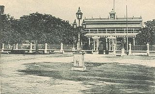
Pondicherry, officially known as Puducherry, is the capital and the most-populous city of the Indian union territory of Puducherry. The city is in the Puducherry district on the southeast coast of India and is surrounded by the state of Tamil Nadu, with which it shares most of its culture and language.

The Puducherry district, also known by its former name Pondicherry district, is one of the four districts of the union territory of Puducherry in South India. The district occupies an area of 290 square kilometres (110 sq mi), spread over 11 non-contiguous enclaves lying on or near the Bay of Bengal within a compact area in the state of Tamil Nadu. According to the 2011 census, the district has a population of 950,289.

The Puducherry Legislative Assembly is the unicameral legislature of the Indian union territory (UT) of Puducherry, which comprises four districts: Puducherry, Karaikal, Mahé and Yanam. The legislative assembly has 33 seats, of which 5 are reserved for candidates from scheduled castes and 3 members are nominated by the Government of India. 30 out of 33 Members are elected directly by the people on the basis of universal adult franchise.
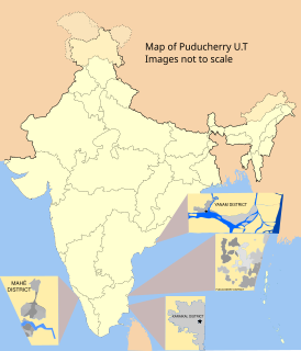
Karaikal district is one of the four districts of the Union Territory of Puducherry in India.
Ingalagi is a panchayat village in Belgaum district in the southern state of Karnataka, India.

Ambagarathur is a revenue city in the Thirunallar taluk of Karaikal District in the Indian union territory of Puducherry. It is situated to the west of Thirunallar. Ambagarathur is 8.3 km distance from its Tensil Main Town Thirunallar. Ambagarathur is 12.9 km distance from its District Headquarters Karaikal. And 108 km distance from its State Main City Pondicherry. The place is famous for BhadraKali amman Temple.
Thirunallar taluk is a taluk of Karaikal District, Puducherry, India. The taluk headquarters is located at Thirunallar.

Villianur is one of 5 Communes in Pondicherry district in the Indian territory of Puducherry. Villianur Commune comes under Villianur Taluk Of Puducherry District. Mannadipet is another commune under Villianur Taluk. Villianur Commune consists of 1 Census Town and 17 Panchayat Villages.

Agni is a panchayat village in the southern state of Karnataka, India. Administratively, Agni is under Shorapur Taluka of Yadgir District in Karnataka. The village of Agni is 1.5 km by road west of the village of Agthirth and 14 km by road north of the village of Hunasagi. The nearest railhead is in Yadgir.
Azalapur is a panchayat village in the southern state of Karnataka, India. Administratively, Azalapur is under Yadgir Taluka of Yadgir District in Karnataka. The village of Azalapur is 3.5 km by road northwest of the village of Ujjelli in Andhra Pradesh, and 20 km by road east of the census town of Saidapur in Yadgir Taluka. The nearest railhead is in Yadgir.
Munderga is a panchayat village in the southern state of Karnataka, India. Administratively, Munderga is under Yadgir Taluka of Yadgir District in Karnataka. The village of Munderga is 6 km by road west of the village of Ramasamudra, and 5 km by road east of the town of Yadgir. The nearest railhead is in Yadgir.
Putpak is a panchayat village in the Northern state of Karnataka, India. Administratively, Putpak is under Yadgir Taluka of Yadgir District in Karnataka. The village of Putpak is on the eastern edge of Yadgir District and Karnataka and is only 6 km by road west of the village of Damaragidda in Telangana. It is 10.5 km by road southeast of the town of Gurmatkal. The nearest railhead is in Yadgir.

Pettai is a panchayat village in the southern state of Tamil Nadu. Administratively, Pettai is under the Gingee Taluk of Villupuram District, Tamil Nadu. Pettai is 18.5 km by road west of the village of Gingee, and 24 km east of the town of Tiruvannamalai.
Sugur is a panchayat village in the southern state of Karnataka, India. Administratively, Sugur is under Shorapur Taluqa of Yadgir District in Karnataka. Sugur lies on the left (north) bank of the Krishna River. The village of Sugur is 3 km by road southwest of the village of Adwadgi and 15 km by road east of the village of Devapur. The nearest railhead is in Yadgir.
Devapur is a panchayat village in the southern state of Karnataka, India. Administratively, Devapur is under Shorapur Taluka of Yadgir District in Karnataka. The village of Devapur is 15 km by road west of the village of Sugur and 26 km by road east of the village of Hunasagi. The nearest railhead is in Yadgir.
Mamadapur is a panchayat village in the southern state of Karnataka, India. Administratively, Mamadapur is under Bijapur Taluka of Bijapur district in Karnataka. The village of Mamadapur is 8.5 km by road southeast of the town of Kambagi, and 43 km by road south of the city of Bijapur.

Lohara Bk. is a Nagar panchayat village in the state of Maharashtra, India. Lohara Bk. is headquarters for and administratively under Lohara Tehsil of Osmanabad District in Maharashtra. There is only the single village of Lohara Bk. in the Lohara (BK) gram panchayat. The village of Lohara Bk. is 22 km by road west of the village of Sastur and 33 km by road east of the town of Tuljapur.

