Nieuw-Vennep is a town in the Dutch province of North Holland. It is a part of the municipality of Haarlemmermeer, and lies about 10 km southwest of Amsterdam Airport Schiphol. It has about 31,300 inhabitants, half of which live in the newly built district of Getsewoud. The built-up area of the town was 3.71 km2, and contained 7,513 residences. The wider statistical area of Nieuw-Vennep has a population of around 40,000. In 2001, Nieuw-Vennep had 17,886 inhabitants, which later doubled due to the development of Getsewoud.

De Adriaan is a windmill in the Netherlands that burnt down in 1932 and was rebuilt in 2002. The original windmill dates from 1779 and the mill has been a distinctive part of the skyline of Haarlem for centuries.

The Hofje van Bakenes or Bakenesserkamer is a hofje in Haarlem, Netherlands, located between the Bakenessergracht and the Wijde Appelaarsteeg. In the Middle Ages "kamer" or "room" meant house. Usually the houses within a hofje consisted of just one room.
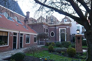
The Lutherse Hofje is a hofje in Haarlem, Netherlands.
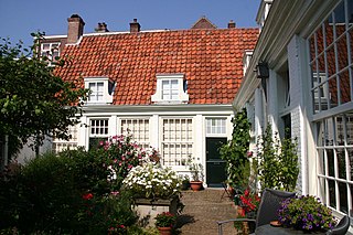
Hofje van Guurtje de Waal is a hofje in Haarlem, Netherlands.

The Remonstrantshofje is a hofje in Haarlem, Netherlands. It is one of the hofjes in Haarlem that is traditionally used to provide housing for elderly people.

The Wijnbergshofje is a hofje in Haarlem, Netherlands, on the Barrevoetstraat.

Spaarndam is a small village in the province of North Holland, the Netherlands, on the Spaarne river and the IJ lake. The oldest part of the village, on the western side of the Spaarne, belongs to the municipality of Haarlem; the newer part on the eastern side is a part of the municipality of Haarlemmermeer. The village is built around a dam in the river, which is also the division line of the two municipalities.

The Diocese of Haarlem-Amsterdam is a Latin diocese of the Catholic Church in the Netherlands. As one of the seven suffragans in the ecclesiastical province of the Metropolitan Archbishop of Utrecht, the diocesan territory comprises the north west of the Netherlands, including the cities of Haarlem and Amsterdam.
Haarlem Stadion is a stadium in Haarlem, Netherlands, and the home stadium of the Dutch amateur football club Haarlem Kennemerland. Formerly home of the defunct professional football club HFC Haarlem, the stadium is located in the north of Haarlem. It was built in 1907, with renovations in 1947 and during the eighties, including the replacement of the south stand, which is an all-seater stand.

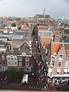
The Grote Markt is the central market square of Haarlem, Netherlands.

The Haarlemmerhout is the oldest public park of the Netherlands. It lies on the south side of Haarlem, on the same old sandy sea wall that is shared by the public park Haagse Bos in The Hague and the Alkmaarderhout in Alkmaar.
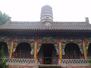
Zunsheng Temple is located in Huyangling, 20 km northeast of the seat of Wutai County.

The Proveniershuis is a hofje and former schutterij on the Grote Houtstraat in Haarlem, Netherlands.
Rushden Parkway railway station is a proposed new railway station to serve the towns of Rushden and Higham Ferrers and the large village of Irchester in Northamptonshire, England. The two towns and village have not seen passenger rail services since 1959. The former station building at Rushden has been preserved and now houses Rushden Station Railway Museum. Rushden Parkway would be built on the Midland Main Line on the site of the former Irchester railway station. In June 2009, the Association of Train Operating Companies (ATOC) commissioned a new report, advocated a park and ride station for Rushden, although the report inadvertently stated that it would be sited in Irthlingborough and not Irchester.

The Archeologisch Museum Haarlem is a museum in the cellar of the Vleeshal on the Grote Markt in Haarlem, the Netherlands, dedicated to promoting interest and conserving the archeological heritage of Kennemerland.

The Koninklijke Hollandsche Maatschappij der Wetenschappen, located on the east side of the Spaarne in downtown Haarlem, Netherlands, was established in 1752 and is the oldest society for the sciences in the country. The society has been housed in its present location, called Hodshon Huis, since 1841. Nearby the society is the Teylers Museum, a closely related museum of natural history founded in 1784. In 2002 the society was awarded the predicate "Royal" when it celebrated 250 years of science studies.
The Sportpaleis Alkmaar is a velodrome and multisport indoor arena in Alkmaar, the Netherlands. The original velodrome, which was built in 1964 and made of concrete, was renovated in 2003. The concrete track was replaced by a wooden track and was now situated in a completely covered hall. The cycling track is 250 m (820 ft) in length and 6.5 m (21 ft) in width. The maximum slope is 42°. The track encloses a multifunctional indoor sportsfield. The hall has a capacity for 4750 spectators.

Garston Park is a park in Garston, Hertfordshire, a suburb of Watford in Hertfordshire. An area of 6.4 hectares, about half of the park, is a Local Nature Reserve. It is owned and managed by Watford Borough Council.
Don Thup railway station is a railway station located in Khanthuli Subdistrict, Tha Chana District, Surat Thani. It is a class 3 railway station located 570.057 km (354.2 mi) from Thon Buri railway station