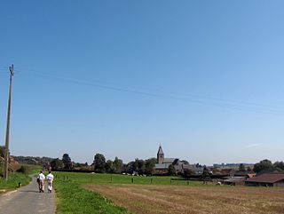
Steenkerque is a Belgian village 50 kilometres (31 mi) south-west of Brussels and 10 kilometres (6.2 mi) south of Enghien. Steenkerque is part of the municipality of Braine-le-Comte, province of Hainaut, Wallonia.
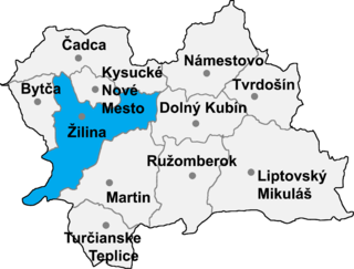
Šuja is a village municipality in Žilina District in the Žilina Region of northern Slovakia.

Korczowa is a village in the administrative district of Gmina Radymno, within Jarosław County, Subcarpathian Voivodeship, in south-eastern Poland, close to the border with Ukraine.
Dębowy Gaj is a village in the administrative district of Gmina Lwówek Śląski, within Lwówek Śląski County, Lower Silesian Voivodeship, in south-western Poland.
Bałucz is a village in the administrative district of Gmina Łask, within Łask County, Łódź Voivodeship, in central Poland. It lies approximately 8 kilometres (5 mi) north-west of Łask and 33 km (21 mi) south-west of the regional capital Łódź.
Wola Malowana is a village in the administrative district of Gmina Kodrąb, within Radomsko County, Łódź Voivodeship, in central Poland. It lies approximately 13 kilometres (8 mi) east of Radomsko and 81 km (50 mi) south of the regional capital Łódź.
Brenica is a village in the administrative district of Gmina Lubochnia, within Tomaszów Mazowiecki County, Łódź Voivodeship, in central Poland. It lies approximately 4 kilometres (2 mi) north of Lubochnia, 14 km (9 mi) north of Tomaszów Mazowiecki, and 45 km (28 mi) east of the regional capital Łódź.
Zgoda is a village in the administrative district of Gmina Jarosław, within Jarosław County, Subcarpathian Voivodeship, in south-eastern Poland. It lies approximately 6 kilometres (4 mi) east of Jarosław and 54 km (34 mi) east of the regional capital Rzeszów.
Bobrówka is a village in the administrative district of Gmina Laszki, within Jarosław County, Subcarpathian Voivodeship, in south-eastern Poland. It lies approximately 4 kilometres (2 mi) north-west of Laszki, 14 km (9 mi) east of Jarosław, and 62 km (39 mi) east of the regional capital Rzeszów.
Miękisz Nowy is a village in the administrative district of Gmina Laszki, within Jarosław County, Subcarpathian Voivodeship, in south-eastern Poland. It lies approximately 6 kilometres (4 mi) east of Laszki, 21 km (13 mi) east of Jarosław, and 69 km (43 mi) east of the regional capital Rzeszów.

Miękisz Stary is a village in the administrative district of Gmina Laszki, within Jarosław County, Subcarpathian Voivodeship, in south-eastern Poland. It lies approximately 4 kilometres (2 mi) east of Laszki, 20 km (12 mi) east of Jarosław, and 68 km (42 mi) east of the regional capital Rzeszów.
Wietlin is a village in the administrative district of Gmina Laszki, within Jarosław County, Subcarpathian Voivodeship, in south-eastern Poland. It lies approximately 7 kilometres (4 mi) west of Laszki, 10 km (6 mi) east of Jarosław, and 58 km (36 mi) east of the regional capital Rzeszów.
Tywonia is a village in the administrative district of Gmina Pawłosiów, within Jarosław County, Subcarpathian Voivodeship, in south-eastern Poland. It lies approximately 6 kilometres (4 mi) north of Pawłosiów, 4 km (2 mi) north-west of Jarosław, and 45 km (28 mi) east of the regional capital Rzeszów.
Wola Roźwienicka is a village in the administrative district of Gmina Roźwienica, within Jarosław County, Subcarpathian Voivodeship, in south-eastern Poland. It lies approximately 18 kilometres (11 mi) south of Jarosław and 49 km (30 mi) east of the regional capital Rzeszów.
Piwoda is a village in the administrative district of Gmina Wiązownica, within Jarosław County, Subcarpathian Voivodeship, in south-eastern Poland. It lies approximately 8 kilometres (5 mi) north-east of Jarosław and 54 km (34 mi) east of the regional capital Rzeszów.

Ryszkowa Wola is a village in the administrative district of Gmina Wiązownica, within Jarosław County, Subcarpathian Voivodeship, in south-eastern Poland. It lies approximately 15 kilometres (9 mi) east of Jarosław and 62 km (39 mi) east of the regional capital Rzeszów.
Wiązownica is a village in Jarosław County, Subcarpathian Voivodeship, in south-eastern Poland. It is the seat of the gmina called Gmina Wiązownica.
Rzeczyca Długa is a village in the administrative district of Gmina Radomyśl nad Sanem, within Stalowa Wola County, Subcarpathian Voivodeship, in south-eastern Poland. It lies approximately 10 kilometres (6 mi) south-east of Radomyśl nad Sanem, 6 km (4 mi) north of Stalowa Wola, and 67 km (42 mi) north of the regional capital Rzeszów. The village is located in the historical region Galicia.
Sławin is a village in the administrative district of Gmina Sieroszewice, within Ostrów Wielkopolski County, Greater Poland Voivodeship, in west-central Poland. It lies approximately 7 kilometres (4 mi) east of Sieroszewice, 26 km (16 mi) east of Ostrów Wielkopolski, and 116 km (72 mi) south-east of the regional capital Poznań.
Stare Worowo is a village in the administrative district of Gmina Złocieniec, within Drawsko County, West Pomeranian Voivodeship, in north-western Poland. It lies approximately 13 kilometres (8 mi) north of Złocieniec, 21 km (13 mi) north-east of Drawsko Pomorskie, and 102 km (63 mi) east of the regional capital Szczecin.


