
Nagaland is a state in northeastern India. It is bordered by the state of Assam to the west, Arunachal Pradesh and Assam to the north, Myanmar to the east, and Manipur to the south. The state capital is Kohima, the largest city is Dimapur and the coldest and highest altitude town is Pfutsero. It has an area of 16,579 square kilometres (6,401 sq mi) with a population of 1,980,602 per the 2011 Census of India, making it one of the smallest states of India. Nagaland is one of three states in India where the population is mostly Christian.

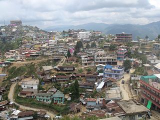
Kohima is the capital city of India's north eastern state of Nagaland. With a resident population of almost 100,000, it is the second largest city in the state. Originally known as Kewhira, Kohima was founded in 1878 when the British Empire established its headquarters of the then Naga Hills. It officially became the capital after the state of Nagaland was inaugurated in 1963. Kohima was the site of one of the bloodiest battles of World War II. The battle is often referred to as the ‘Stalingrad of the East’. In 2013, the British National Army Museum voted the Battle of Kohima to be ‘Britain's Greatest Battle’.
Angami is an Naga language spoken in the Naga Hills in the northeastern part of India, in Kohima district, Nagaland. In 2001, there is an estimate of 125,000 first language (L1) Angami speakers. Under the UNESCO’s Language Vitality and Endangerment framework, Angami is at the level of "vulnerable", meaning that it is still spoken by most children, but "may be restricted to certain domains".
Zunheboto (Pron:/ˌzʌnˈhiːbəʊtəʊ/), also known as Zunhebo, is a town in the state of Nagaland. Zunheboto is inhabited by the Sumi Nagas who are known for their martial skills. It is the location of the largest Baptist church in Asia, the Sumi Baptist Church, Zunheboto.

Mokokchung (Pron:/ˌməʊkɒkˈtʃʌŋ/) is a town and a municipality in Mokokchung district in the Indian state of Nagaland. It is the district headquarters as well as the main urban hub of Mokokchung district. Mokokchung is the cultural nervecentre of the Ao people and is economically and politically the most important urban centre in northern Nagaland. In fact it is third most important urban hub in all of Nagaland after Dimapur and Kohima. Besides this the Government of Nagaland has also recognised Mokokchung district as 'Land of Pioneers' because this place has produced a great number of luminaries in many fields. The town is made up of 16 wards of which Kumlong, Sangtemla, Alempang and Yimyu are the largest. Mokokchung is particularly noted for its extravagant Christmas, New Year, Moatsu and Tsungremong celebrations. Its tradition of celebrating Christmas and New Year midnight celebrations in the main town square is regarded as one of the unique features of Mokokchung. Historically, Mokokchung was one of the first Naga Hills sites where the Assam Rifles, led by Britishers, established their outposts in the later part of the 19th century. Much of the town initially grew around this post located in the DC Hill. The British administration was then gradually extended eastwards towards the remoter parts of the Naga Hills.
Dimapur (Pron:/ˌdɪməˈpʊə/) is a district of Nagaland state in India. Its headquarters is the city of Dimapur. As of 2011 it is the most populous district of Nagaland.

Phek (pron:/ˈfɛk/) is a district of Nagaland state, India. It was established in 1973. The district headquarters are in the town of Phek.

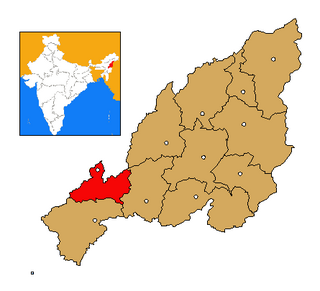
Zunheboto (Pron:/ˌzʌnˈhiːbəʊtəʊ/) is a district of Nagaland state in India.

Tuensang (Pron:/ˌtjuːənˈsæŋ/) is a town and the headquarters of its Tuensang district in Nagaland with a population of 36,774.
Ao Baptist Arogo Mungdang (ABAM) is the largest Baptist Association affiliated to the Nagaland Baptist Church Council, with over 163 full-fledged churches and 10 fellowships. As of 2016, the Association had 110,010 baptized members.
The CSI Tiruchirappalli Thanjavur Diocese is a diocese of Church of South India in Tamil Nadu state of India. The diocese is one among the 24 dioceses of Church of South India and was one of the first 14 dioceses to be formed at the inaugural of the Church of South India in 1947.
Chokri, is one of three languages spoken by the Chakhesang Naga of Phek district, Nagaland state, India. Cheswezumi is the most important Chokri village in Nagaland. There are also some Chokri speakers residing in Senapati district, Manipur. In 1991, it was estimated that there were 20,000 native Chokri speakers.

Neiliezhü Üsou was an influential Baptist minister and public leader from the North-Eastern state of India, Nagaland. He belonged to the Angami Naga tribe and hailed from Nerhema Village in Kohima district, Nagaland, India. He was well known for his interpretive skills, powerful sermons and involvement with the State Government.
KhezhaNaga or KhuzhaNaga, is a major language of Chakhesang community of Phek District in the eastern part of Nagaland, India. It is generally spoken by the Khezha people and is one of the three major languages of the Chakhesang Naga tribe. Khezha or Khuzhale is predominantly spoken in Pfutsero and Chizami region of Phek District. It is also spoken by few villages in the western part of Ukhrul District in Manipur State, India.

Bangomunda a tehsil located at about 95 km from Balangir in Titlagarh sub-division of Bolangir district, Odisha, India, has historical importance. Bangomunda is the new name of Banganmura which means Brinjal Firm.
Jalukie 'B' is a village in the Peren district of Nagaland, India. It is located in the Jalukie Circle.
Jalukie is a town in the Peren district of Nagaland, India. Located in the Jalukie Circle, it is governed by a town committee.
Lampong Sheanghah (LS), a small village with about 120 households located in the Eastern part of Nagaland, India under Mon district. It is located twelve kilometers away from the district headquarter. The name 'Lampong' literally means ‘ junction’ that connects Longwa village, the international border between India and Myanmar in the East, Assam in the West and Mon in the South-East. The distance between the village and the state capital Kohima is 354 km.
Khezhakeno is a village in the Phek District of Nagaland, India. It is a historical village of the Nagas. It is located in the region 25.30°N 94.12°E at an elevation of 1660 meters above sea level and shares its border with the Manipur state in the south. The village is 48 km from the state capital Kohima via NEC Viswema-Kidima-Zuketsa road and is 23 km away from its Sub-divisional headquarter Pfutsero. It falls under the Administrative Circle of Khezhakeno HQ headed by an Extra Assistant Commissioner.

Viswema is a Southern Angami Naga village located 22 km south of Kohima, the capital of Nagaland. With a resident population of 7417, it is the second biggest village in the state and is part of the contiguous built-up of the Kohima metropolitan area that extends into the neighboring areas of Jakhama, Kigwema, Phesama and Khuzama in the Southern Angami region, forming the second largest urban agglomerations in Nagaland. Its vast territory also lies across the inter-state boundary in Manipur where notable features including Mount Tempü(Iso) at 9822 feet (2994m) also the highest peak in Manipur, the thick forest of Kezol–tsa and a major portion of the Dzüko Valley is located.