
Bulgaria is a country situated in Southeast Europe and occupies the eastern quarter of the Balkan peninsula, being the largest country within its geographic boundaries. It is bordering Romania to the north, Serbia and North Macedonia to the west, Greece and Turkey to the south, and the Black Sea to the east. The northern border with Romania follows the river Danube until the city of Silistra. The land area of Bulgaria is 110,994 square kilometres (42,855 sq mi), slightly larger than that of Iceland or the U.S. state of Tennessee. Considering its relatively small size, Bulgaria has a great variety of topographical features. Even within small parts of the country, the land may be divided into plains, plateaus, hills, mountains, basins, gorges, and deep river valleys. The geographic center of Bulgaria is located in Uzana.

Bithynia was an ancient region, kingdom and Roman province in the northwest of Asia Minor, adjoining the Sea of Marmara, the Bosporus, and the Black Sea. It bordered Mysia to the southwest, Paphlagonia to the northeast along the Pontic coast, and Phrygia to the southeast towards the interior of Asia Minor.

Ardèche is a department in the Auvergne-Rhône-Alpes region of Southeastern France. It is named after the Ardèche River and had a population of 320,379 as of 2013. Its largest cities are Aubenas, Annonay, Guilherand-Granges, Tournon-sur-Rhône and Privas (prefecture). Its prefecture is in Privas, but its largest city is in Annonay.

Chilean wine has a long history for a New World wine region, as it was the 16th century when the Spanish conquistadors brought Vitis vinifera vines with them as they colonized the region. In the mid-19th century, French wine varieties such as Cabernet Sauvignon, Merlot, Carmenère and Franc were introduced. In the early 1980s, a renaissance began with the introduction of stainless steel fermentation tanks and the use of oak barrels for aging. Wine exports grew very quickly as quality wine production increased. The number of wineries grew from 12 in 1995 to over 70 in 2005.

The Terme River is a short river in Samsun Province, Turkey draining into the Black Sea. Its sources are in the Pontic Mountains. It runs through the fertile Çarşamba plain to Salıpazarı, where it splits into three tributaries. The city of Terme is on the river, about 5 km from its mouth.

Tokat Province is a province in northern Turkey. Its adjacent provinces are Amasya to the northwest, Yozgat to the southwest, Sivas to the southeast, and Ordu to the northeast. Its capital is Tokat, which lies inland of the middle Black Sea region, 422 kilometers from Ankara.

The Eurotas or Evrotas is the main river of Laconia and one of the major rivers of the Peloponnese, in Greece. The river's springs are located just northwest of the border between Laconia and Arcadia, at Skortsinos. The river is also fed by underwater springs at Pellana and by tributaries coursing down from Mt. Taygetos and Mt. Parnon, which flank the Eurotas valley to the west and east, respectively. The river is 82 kilometres (51 mi) long, flowing in a north-south direction and emptying into the Laconian Gulf. Its drainage basin is 2,239 km2 (864 sq mi).

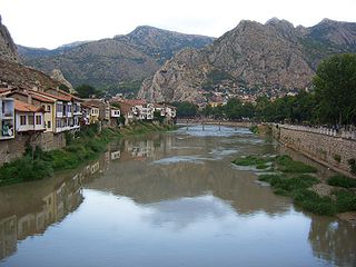
Niksar, historically known as Neocaesarea (Νεοκαισάρεια), is a city in Tokat Province, Turkey. It was settled by many empires, being once the capital city of the province. Niksar is known as "Çukurova of the North-Anatolia" due to its production of many kinds of fruits and vegetables except citrus fruits. On May 2, 2018, Niksar was included in the World Heritage tentative list.
Cabira or Kabeira was a town of ancient Pontus in Asia minor, at the base of the range of Paryadres, about 150 stadia south of Eupatoria or Magnopolis, which was at the junction of the Iris and the Lycus. Eupatoria was in the midst of the plain called Phanaroea, whereas Cabira, as Strabo says was at the base of the Paryadres. Mithridates the Great built a palace at Cabira; and there was a water-mill there, and places for keeping wild animals, hunting grounds, and mines. Less than 200 stadia from Cabira was the remarkable rock or fortress called Caenon, where Mithridates kept his most valuable things. Cn. Pompeius took the place and its treasures, which, when Strabo wrote, were in the Roman Capitol. In Strabo's time a woman, Pythodoris, the widow of King Polemon, had Cabira with the Zelitis and Magnopolitis. Pompeius made Cabira a city, and gave it the name Diospolis (Διόσπολις). Pythodoris enlarged it, gave it the name Sebaste (Σεβαστή), which is the Greek equivalent to Augusta, and used it as her royal residence. Near Cabira probably at a village named Ameria, there was a temple with a great number of slaves belonging to it, and the high priest enjoyed this benefice. The god Men of Pharnaces was worshipped at Cabira. Mithridates was at Cabira during the winter that L. Lucullus was besieging Amisus and Eupatoria. Lucullus afterwards took Cabira. There are some autonomous coins of Cabira with the epigraph "Καβηρων".

Bolvadin is a city and district of Afyonkarahisar Province in Turkey. It covers an area of 1,108 km² and has an altitude of 1,016 m. The population of the district center is 31,387 (2010). The mayor is Fatih Kayacan.
Comana Pontica, was an ancient city located in ancient Pontus, now in modern Turkey.
The Yeşilırmak is a river in northern Turkey. From its source north-east of Sivas, it flows past Tokat and Amasya, crosses the Pontic Mountains and the Çarşamba Plain, reaching the Black Sea east of Samsun after 418 km (260 mi).

Tikveš plain is situated in central North Macedonia. It is known for an artificial lake, which is the site of the Tikveš Hydroelectric Power Station. It is home to the towns of Kavadarci and Negotino. Famous for its wine, Tikveš is the center of the Macedonian wine production which has been cultivated for more than 120 years. The region is also famous for its yogurt and sour milk.

The Kingdom of Pontus was a Hellenistic kingdom, centered in the historical region of Pontus and ruled by the Mithridatic dynasty of Persian origin, which may have been directly related to Darius the Great and the Achaemenid dynasty. The kingdom was proclaimed by Mithridates I in 281 BC and lasted until its conquest by the Roman Republic in 63 BC. The Kingdom of Pontus reached its largest extent under Mithridates VI the Great, who conquered Colchis, Cappadocia, Bithynia, the Greek colonies of the Tauric Chersonesos, and for a brief time the Roman province of Asia. After a long struggle with Rome in the Mithridatic Wars, Pontus was defeated. The western part of it was incorporated into the Roman Republic as the province Bithynia et Pontus; the eastern half survived as a client kingdom until 62 AD.

Albuñuelas is a village at the head of the Lecrin Valley, Granada, Spain. It is made up of three neighbourhoods (barrios): Alto, Bajo and Fernán Núñez. It is situated on the European route Nº 4.
Eupatoria and Magnopolis was a Hellenistic city in the Kingdom of Pontus. The city was founded by Mithridates VI Eupator just south of where the Lycus flows into the Iris, the west end of the fertile valley of Phanaroea, probably in or near the village of Çevresu, Erbaa district, Tokat Province.

The Brigalow Belt is a wide band of acacia-wooded grassland that runs between tropical rainforest of the coast and the semi-arid interior of Queensland, Australia. The Interim Biogeographic Regionalisation for Australia (IBRA) divides the Brigalow Belt into two IBRA regions, or bioregions, Brigalow Belt North (BBN) and Brigalow Belt South (BBS). The North and South Brigalow Belt are two of the 85 bioregions across Australia and the 15 bioregions in Queensland. Together they form most of the Brigalow tropical savanna ecoregion.
The Kelkit River, is a river in the Black Sea Region of Turkey. It is the longest tributary of the Yeşilırmak. Its name derives from the Armenian Gayl get. Its Greek name is Lykos, also meaning 'wolf', and romanized as Lycus.

Alentejo is a geographical, historical, and cultural region of south–central and southern Portugal. In Portuguese, its name means "beyond the Tagus river" (Tejo).