Related Research Articles
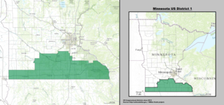
Minnesota's 1st congressional district extends across southern Minnesota from the border with South Dakota to the border with Wisconsin. The first district is primarily a rural district built on a strong history of agriculture, although this is changing rapidly due to strong population growth in Rochester and surrounding communities. The first district is also home to several of Minnesota's major mid-sized cities, including Rochester, Mankato, Winona, Austin, Owatonna, Albert Lea, New Ulm, and Worthington. This district is currently represented by Republican Jim Hagedorn of Blue Earth.

The New England Seamounts is a chain of over twenty underwater extinct volcanic mountains known as seamounts. This chain is located off the coast of Massachusetts in the Atlantic Ocean and extends over 1,000 km from the edge of Georges Bank. Many of the peaks of these mountains rise over 4,000 m from the seabed. The New England Seamounts chain is the longest such chain in the North Atlantic and is home to a diverse range of deep sea fauna. Scientists have visited the chain on various occasions to survey the geologic makeup and biota of the region. The chain is part of the Great Meteor hotspot track and was formed by the movement of the North American Plate over the New England hotspot. The oldest volcanoes that were formed by the same hotspot are northwest of Hudson Bay, Canada. Part of the seamount chain is protected by Northeast Canyons and Seamounts Marine National Monument.
The Beaver River is a river of Minnesota. The river flows through the southwest part of Morse Township in northern Saint Louis County. It is a tributary of the Bear Island River.
The Beaver River is a 23.4-mile-long (37.7 km) river in Lake County, Minnesota. It flows into Lake Superior.
The Burntside River is a river of Minnesota. The river flows through the west–central portion of Morse Township in northern Saint Louis County.

The Caribou River is a 15.0-mile-long (24.1 km) river in northern Minnesota, the United States. It rises in a swamp about .6 miles (1 km) south of Morris Lake and two miles (3.2 km) east of Echo Lake, near the Lake/Cook County line, at an altitude about 1620 feet above sea level. It descends some 1,020 feet in elevation as it flows south to its mouth at Lake Superior, also near the eastern border of Lake County.
The Dead River is a river of Minnesota. The river flows through the north–central part of Morse Township in northern Saint Louis County, and is a tributary of the Burntside River.
The Greenwood River is a river of Minnesota. It is a tributary of the Stony River.
The Isabella River is a river of Minnesota.
The Island River is a river of Minnesota.
The Kawishiwi River is a river of Minnesota.
The Little Knife River (East) is a 5.7-mile-long (9.2 km) river in Lake County, Minnesota, United States. It is a tributary of the Knife River, located northwest of the city of Two Harbors. A second Little Knife River flows into the Knife River from the west, through St. Louis County.
The Snake River is a river of Minnesota. It is a tributary of the Isabella River.
The South Kawishiwi River is a river of Minnesota.
The Stony River (Minnesota) is a river of Minnesota. It flows into the Rainy River.
Galma Koudawatche is a village and rural commune in Niger.

The Manitou River is a 24.9-mile-long (40.1 km) river in northern Minnesota, which drains into Lake Superior along its north shore about three miles northeast of Little Marais. It flows southeast through the Superior National Forest, Finland State Forest, and George H. Crosby Manitou State Park in Lake County.
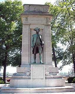
American Revolution Statuary is a group of fourteen statues in Washington, D.C., listed with the National Register of Historic Places. The statues are scattered across Washington, mainly in squares and traffic circles, with four statues of European officers displayed in Lafayette Square, across from the White House
Stewart River is a stream in Lake County, in the U.S. state of Minnesota.
Dry Creek is a stream in Lincoln and Warren counties of the U.S. state of Missouri. It is a tributary of Big Creek. A variant name was "Dry Branch".