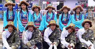
The Sherpas are one of the Tibetan ethnic groups native to the most mountainous regions of Nepal and Tibetan Autonomous Region of China.
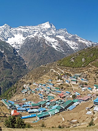
Namche Bazaar is a town in Khumbu Pasanglhamu Rural Municipality in Solukhumbu District of Koshi Province in northeastern Nepal. It is located within the Khumbu area at 3,440 metres (11,286 ft) at its low point, populating the sides of a hill. Most Sherpa in the tourism business hail from the Namche area. Namche is the main trading center and hub for the Khumbu region.

Tengboche is a village in Khumbu Pasanglhamu rural municipality in the Khumbu subregion of Province No. 1 in Nepal, located at 3,867 metres (12,687 ft). Within the village is an important Buddhist monastery, Tengboche Monastery, which is the largest gompa in the Khumbu region. The structure was built in 1923. In 1934, it was destroyed by an earthquake but subsequently rebuilt. It was destroyed again by a fire in 1989, and again rebuilt with the help of volunteers and the provision of foreign aid. Tengboche has a panoramic view of the Himalayan mountains, including the well-known peaks of Tawache, Everest, Nuptse, Lhotse, Ama Dablam, and Thamserku. Tenzing Norgay, the first man to reach the summit of Mount Everest with Sir Edmund Hillary, was born in the area in the village of Thani and was once sent to Tengboche Monastery to be a monk.

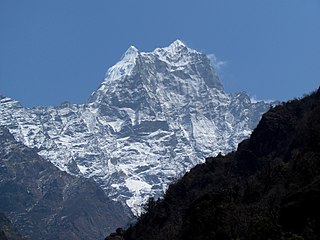
Khumbu is a region of northeastern Nepal on the Nepalese side of Mount Everest. It is part of the Solukhumbu District, which in turn is part of Koshi Pradesh. Khumbu is one of three subregions of the main Kirat Kulung and Sherpa settlement of the Himalaya, the other two being Solu and Pharak. It includes the town of Namche Bazaar as well as the villages of Thame, Khumjung, Pangboche, Pheriche and Kunde. The famous Buddhist monastery at Tengboche is also located in Khumbu.
Kusum Kanguru is a mountain in the Khumbu Region of the Himalayas in Nepal. Its name, Kusum Kanguru, means "Three Snow-White Gods" in the Sherpa language, which refers to the triple summit of the mountain.
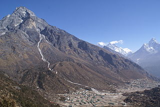
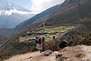
Khumjung is a village in Khumbu Pasanglhamu rural municipality of Solukhumbu District in Province No. 1 of north-eastern Nepal. It is located in the Khumbu sub-region inside Sagarmatha National Park, a world heritage site. The village lies at an elevation of 3,790 metres above sea level, near Mount Khumbila.

Khumbutse is the first mountain west (6 km) of Mount Everest. It lies at the border between Nepal and China.

Gorak Shep, also spelled Gorakshep, is a settlement nestled on the periphery of a frozen lakebed blanketed with sand in Nepal, sharing its name with the locale. Situated at an elevation of 5,164 meters near Mount Everest, it remains uninhabited for most of the year, reopening only for the Mount Everest trekking season.

Solukhumbu District (Nepali: सोलुखुम्बु जिल्ला, Sherpa: ཤར་ཁུམ་བུ་རྫོང་།, Wylie: shar khum bu dzong) is one of 14 districts of Koshi Province of eastern Nepal. As the name suggests, it consists of the sub-regions Solu and Khumbu. The closest post office to Solukhumbu with a postal code assigned to it is the Sindhuli D.P.O., which has the postal code 56000.

Dingboche is a Sherpa village at an elevation of 4,410 m (14,470 ft) in the Khumbu region of northeastern Nepal. Its population was estimated at approximately 200 in 2011.
There are two base camps on Mount Everest, on opposite sides of the mountains: South Base Camp is in Nepal at an altitude of 5,364 metres (17,598 ft), while North Base Camp is in Tibet at 5,150 metres (16,900 ft).
Dole is a small village in the Khumbu region of Nepal. It lies in the Dudh Kosi River valley just north of Khumjung and south of Machhermo at an altitude of 4038m.

Chukhung is a lodge village serving trekkers and climbers in the Khumbu region of Nepal in the Himalayas south of Mount Everest. As per 2011 census, this village has the population of 159 locals Sherpa's and 26 local households.

Everest Marathon is an annual marathon event, held in the district of Solukhumbu, Nepal, around the vicinity of Mount Everest in May. With its starting point at 5401m Meter from where the Climbing of Mount Everest Peak starts through the Ice Fall, the marathon is considered to be one of the highest and toughest races in the world. The marathon starts at the Mt. Everest Base Camp, and moves through the traditionally used high Sherpa trails of Khumbu Valley.
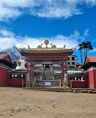
Tengboche Monastery, also known as Dawa Choling Gompa, in the Tengboche village in Khumjung in the Khumbu region of eastern Nepal is a Tibetan Buddhist monastery of the Sherpa community. Situated at 3,867 metres (12,687 ft), the monastery is the largest gompa in the Khumbu region of Nepal. It was built in 1916 by Lama Gulu with strong links to its mother monastery known as the Rongbuk Monastery in Tibet. In 1934, it was destroyed by an earthquake and was subsequently rebuilt. In 1989, it was destroyed for a second time by a fire and then rebuilt with the help of volunteers and international assistance.

The Imja Khola is a tributary of the Dudh Kosi river in eastern Nepal. It drains the slopes of Mount Everest. The Khumbu Glacier melts into the Lobujya (Lobuche) River, which flows southward as the Imja Khola to its confluence with the Dudh Kosi at Tengboche.

Machermo is a small village in the Khumbu region of eastern Nepal. It lies in the Dudh Kosi River valley just north of Dole and south of Gokyo at an altitude of 4470m, just below the terminal moraine of the Ngozumpa glacier, the longest glacier in the Himalayas.

Monjo is a small village in the Khumbu region of Nepal. It lies in the Dudh Kosi river valley just north of Phakding and south of Jorsale, at an altitude of 2,835 m, just below the Sagarmatha National Park entrance gate and check-point, one of the UNESCO World Heritage Site since 1979. As per the census of 2011, Monjo village has a population of 114 people. All of them are followers of Buddhism and engaged in the tourism business.

Phakding is a small village in the Khumbu region of Nepal. It lies in the Dudh Kosi river valley just north of Lukla and south of Monjo, at an altitude of 2,610 m, one of the UNESCO World Heritage Site since 1979. Phakding has a population of 550 locals, mostly Sherpa and Tamang. All of these people belong to Tibetian Buddhism and pray in a small Gompa at the centre of the village.

Khumbu Pasanglhamu is one of 7 rural municipalities (Gaunpalika) in Solukhumbu district of Province No. 1 of Nepal. Khumjung, Namche & Jubing and Chaurikharka were incorporated while creating it. It has the total population of 9,133 according to the 2011 Nepal census and area of 1,539.11 square kilometres (594.25 sq mi). The admin centre of this gaunpalika is that of the Chaurikharka.
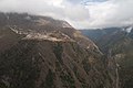 Phortse at the confluence of two valleys in Khumbu region.
 Phortse village
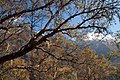 Trees
Trees

