Related Research Articles

The Kaveri is one of the major Indian rivers flowing through the states of Karnataka and Tamil Nadu. The Kaveri river rises at Talakaveri in the Brahmagiri range in the Western Ghats, Kodagu district of the state of Karnataka, at an elevation of 1,341 m above mean sea level and flows for about 800 km before its outfall into the Bay of Bengal. It reaches the sea in Poompuhar in Mayiladuthurai district. It is the third largest river – after Godavari and Krishna – in southern India, and the largest in the State of Tamil Nadu, which, on its course, bisects the state into north and south. In ancient Tamil literature, the river was also called Ponni.

Erode District is one of the 38 districts in the state of Tamil Nadu in India. It was the largest district by area in the state before the formation of Tirupur District in 2009. The headquarters of the district is Erode. It is divided into two revenue divisions, Erode and Gobichettipalayam, and is further subdivided into 10 taluks. Erode District was a part of Coimbatore District before its division into two on 17 September 1979. It covers an area of 5,722 square kilometres (2,209 sq mi), and as of 2011, had a population of 2,251,744.

The Buckingham Canal is a 796 kilometres (494.6 mi)-long fresh water navigation canal, that parallels the Coromandel Coast of South India from Kakinada City in the Kakinada district of Andhra Pradesh to Viluppuram District in Tamil Nadu. The canal connects most of the natural backwaters along the coast to Chennai (Madras) port.

The Noyyal River is a small river in Western Tamil Nadu, and a tributary of Kaveri River. It rises from the Vellingiri hills in the Western Ghats in Tamil Nadu, very close to Kerala border, and flows through many villages and the cities of Coimbatore, and Tirupur finally draining into the Kaveri River at Noyyal, a village in Karur district named after the river itself. The river's basin is 180 km (110 mi) long and 25 km (16 mi) wide and covers a total area of 3,500 km2 (1,400 sq mi). Cultivated land in the basin amounts to 1,800 km2 (690 sq mi) while the population density is 120 people per km² (311/mi²) in the countryside, and 1000 people per km² (2590/mi²) in the cities. The area is known for its scanty rainfall and the development of the Noyyal River Tanks System to hold any overflow from the rains plus the water of the Northeast and Southwest monsoon season was ecologically important. Kausika river in the northern side of Coimbatore district along with its lake and pond systems is an important tributory. The 173 km (107 mi) long tributary of the Kaveri River filled 32 tanks. These interconnecting tanks held the water flowing from the Noyyal.

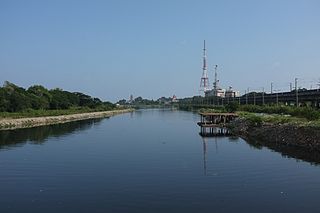
Erode is a city in the Indian state of Tamil Nadu. Erode is the seventh largest urban agglomeration in the state, after Chennai, Coimbatore, Madurai, Tiruchirapalli, Tiruppur and Salem. It is also the administrative headquarters of the Erode district. Administered by a city municipal corporation since 2008, Erode is a part of Erode Lok Sabha constituency that elects its member of parliament. Located on the banks of River Kaveri, it is situated centrally on South Indian Peninsula, about 400 kilometres (249 mi) southwest of its state capital Chennai, 250 kilometres (155 mi) south of Bengaluru, 100 kilometres (62 mi) east of Coimbatore and 275 kilometres (171 mi) east of Kochi. Erode is an agricultural, textile and a BPO hub and among the largest producers of turmeric, hand-loom and knitwear, and food products.

Bhavani is an Indian river which flows through Indian states of Kerala and Tamil Nadu, India. It originates from the Western Ghats of Kerala and is one among the 3 rivers of Kerala which flows in eastward direction.

Bhavani is a Municipality in Erode District, Tamil Nadu, India. It is located at the northern periphery of Erode City Municipal Corporation and is around 105 km (65 mi) from Coimbatore and 60 km (37 mi) from Tiruppur and Salem. Bhavani is also known as "Carpet City" as it is known for its carpet industry; blankets and carpets manufactured in the town are known as Bhavani Jamakkalam. As of 2011, the town covers an area of 2.17 square kilometres (0.84 sq mi) and has a population of 39,225. It is a grade II municipality.
The Cooum river, or simply Koovam, is one of the shortest classified rivers draining into the Bay of Bengal. This river is about 72 km (45 mi) in length, flowing 32 km (20 mi) in the city of Chennai and the rest in rural part. The river is highly polluted in the urban area (Chennai). Along with the Adyar River running parallel to the south and the Kosasthalaiyar River, the river trifurcates the city of Chennai and separates Northern Chennai from Central Chennai. It is also sometimes known as Thiruvallikenni river
Mamannar Kalingarayan Canal is a 56.2-mile (90.5 km) long irrigation canal in the Erode district, Tamil Nadu, India. It was constructed by Chieftain Mamannar Kalingarayan Gounder and completed in 1283. The canal's source is the Kalingarayan Anicut dam near Bhavani, Erode. The canal irrigates approximately 15,743 acres (6,371 ha) of agricultural land.
Unjalur is a panchayat town situated in Erode district in the Indian state of Tamil Nadu. Unjalur is located about 32 kilometres (20 mi) from district headquarters Erode and 8 kilometres (5.0 mi) from Kodumudi, which is known for the Mahudeswarar, Veera Narayana Perumal and Brama Deva temple.
Cauvery Bridge is a stone bridge across the Kaveri river in TRICHY, Tamil Nadu, India. The bridge connects TRICHY CITY in TRICHY with SRIRANGAM in TRICHY district. This two-lane bridge is the primary gateway for the city of SRIRANGAM, from the east.

The Upper Anaicut, also known as Mukkombu is a dam built on the Kaveri River in the state of Tamil Nadu in southern India. The regulator dam was constructed between 1836 and 1838 by Sir Arthur Cotton, a British irrigation engineer who was inspired by the architectural beauty of Grand Anaicut canal built by Karikala Chola in Kallanai of Thanjavur district in the second century.
Upparu River is a river flowing in the Tirupur district of the Indian state of Tamil Nadu.
Tiruppur or Tirupur is a city in the Indian state of Tamil Nadu. Tiruppur is the administrative headquarters of Tiruppur district and the fifth largest city as well as an urban agglomeration in Tamil Nadu. Located on the banks of Noyyal River, it has been ruled at different times, by the Early Pandyas, Medieval Cholas, Later Cholas, Mysore Kingdom and the British. It is about 450 kilometres (280 mi) southwest of the state capital Chennai about 50 kilometres (31 mi) east of Coimbatore 50 kilometres (31 mi) south of Erode and 50 kilometres (31 mi) north of Dharapuram.
Lower Mettur Hydroelectric Project is a hydropower generation project in the South Indian state of Tamil Nadu. It is a 120MW power generation project constructed across the Kaveri River. The project area is in the downstream of Mettur Dam, hence it derives the name. This project consists of four power plants which are located between Mettur in Salem district and Bhavani, Erode. This power generation project is owned by Government of Tamil Nadu and operated by TANGEDCO.
Perumpallam Canal is an irrigation canal in the city of Erode in Tamil Nadu. The canal traverses from west to east across the city and flows into River Kaveri. It runs for a length of about 20 kilometres (12 mi).
Mamannar Kalingarayan Anicut is a dam constructed on the Bhavani river in the South Indian state of Tamil Nadu. It is located just before Kooduthurai where Bhavani combines with Cauvery, in Bhavani, Erode.
V.O.Chidambaranar Park or VOC Park is a recreational park located in the South Indian city of Erode in Tamil Nadu. The park is owned and maintained by Erode Municipal Corporation. This park was built in British India period by chairman Srinivasa Mudaliar. This park was previously known as Srinivasaa Park
Sunnambu Canal is a water stream canal that runs in the northern part of Erode city in India. It was once a celebrated natural channel which supplied water for irrigation of lands in the surrounding areas it runs through. Being one of the minor tributaries to River Kaveri, the canal gets sourced by rain through smaller rivulets and the seepage from LBP Canal.
Nanjai Uthukuli Canal is an irrigation canal that runs in the southern part of Erode city in Tamil Nadu. This canal gets its source of water from Perumpallam Anicut, near Surampatti.
References
- ↑ "Pichaikaranpallam Odai fast turning into a sewer". The Hindu . Retrieved 23 December 2016.
- ↑ "Concern over discharge of untreated effluents". The Hindu . Retrieved 23 December 2016.
- ↑ "Printed and dyed fabrics washed in polluted water". The Hindu . Retrieved 23 December 2016.
- ↑ "Discharge of effluents into water channel continues". The Hindu . Retrieved 23 December 2016.
- ↑ "Wide and clean now". The Hindu . Retrieved 23 December 2016.
- ↑ "TWAD Board-constructed STP remains unused". The Hindu . Retrieved 23 December 2016.
- ↑ "Consultancy Assignment for preparation of Deatailed Project Report for redevelopment of Pichaikaranpallam Odai". N.K.Buildcon Pvt. Ltd. Retrieved 23 December 2016.
Coordinates: 11°21′41″N77°42′34″E / 11.361462°N 77.709439°E
| | This Erode district location article is a stub. You can help Wikipedia by expanding it. |