
Islandia is an unincorporated community and former city in Miami-Dade County, Florida, United States. It is located in the upper Florida Keys on the islands of Elliott Key and other nearby keys, such as Totten Key. It was the only municipality in the Florida Keys not located in neighboring Monroe County. The population was 18 at the 2010 Census. Most residents of the city were National Park Service employees.

Biscayne Bay is a lagoon with characteristics of an estuary located on the Atlantic coast of South Florida. The northern end of the lagoon is surrounded by the densely developed heart of the Miami metropolitan area while the southern end is largely undeveloped with a large portion of the lagoon included in Biscayne National Park.

The Rickenbacker Causeway is a causeway that connects Miami, Florida to the barrier islands of Virginia Key and Key Biscayne across Biscayne Bay.

The Venetian Islands are a chain of artificial islands in Biscayne Bay in the cities of Miami and Miami Beach, Florida. The islands are, from west to east: Biscayne Island (Miami), San Marco Island (Miami), San Marino Island, Di Lido Island, Rivo Alto Island, and Belle Isle. Flagler Monument Island remains an uninhabited picnic island, originally built in 1920 as a memorial to railroad pioneer Henry Flagler. The islands are connected by bridges from the Miami mainland to Miami Beach.

Belle Isle is a neighborhood in the city of Miami Beach on an island in Biscayne Bay, Florida, United States. It is the easternmost of the Venetian Islands, a chain of artificial islands in Biscayne Bay in the cities of Miami and Miami Beach. It is home to apartment buildings, a portion of the Venetian Causeway, a city of Miami Beach park, and a hotel. It is between Rivo Alto Island and the main barrier island of Miami Beach.
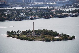
Flagler Memorial Island is an uninhabited artificial island of South Beach in the city of Miami Beach in Biscayne Bay, Florida. A 110-foot (34 m) high obelisk with allegorical sculptures at its base stands as a monument to Miami pioneer Henry M. Flagler, and was built in the center of the freshly constructed island in memory of Flagler, who died in 1913.

The Bay Shore Historic District is a U.S. historic district located in Miami, Florida. The district is bounded by Northeast 55th Street, Biscayne Boulevard, Northeast 60th Street and Biscayne Bay, in the Morningside section of the Upper Eastside neighborhood. It contains 223 historic buildings.

Crandon Park is an 808-acre (3.27 km2) urban park in metropolitan Miami, occupying the northern part of Key Biscayne. It is connected to mainland Miami via the Rickenbacker Causeway.

Boca Chita Key is the island north of the upper Florida Keys in Biscayne National Park, Miami-Dade County, Florida.
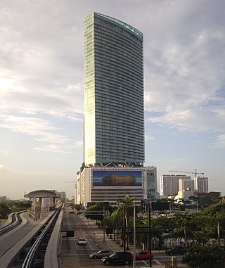
MarinaBlue, also known as Marina Blue, is a skyscraper in Miami, Florida, United States. It is located in northeastern Downtown, on Biscayne Bay along the west side of Biscayne Boulevard. The tower was one of the first buildings in Park West to be completed. Built by Hyperion Development, the developers of another building named Blue on the Bay further uptown, the building finished construction in May 2007. Marinablue is located across the street from the Miami-Dade Arena. The building rises 615 feet (187 m), and has 57 floors. Marinablue is almost all-residential, with some retail and office space on the lower floors. The building was opened to residential occupancy since the spring of 2008. The building currently stands as the 9th-tallest in Miami and the 10th-tallest in Florida, as well as the 5th-tallest residential building in the city and the state.

1800 Club is a residential skyscraper in the Edgewater neighborhood of Miami, Florida, United States. It was completed in 2007. The building is located east of Biscayne Boulevard and fronts Margaret Pace Park and Biscayne Bay. The building is 423 feet (129 m) tall, and contains 40 floors. Floors 1-5 are occupied by retail, while floors 6-40 are residential condominiums and apartments. The building is located at the corner of North Bayshore Drive and Northeast 18th Street. It was awarded the SARA Design Award in 2002 for its exterior architectural appeal.

The Upper Eastside is a neighborhood in Miami, Florida. It is north of Edgewater, east of Little Haiti, south of the village of Miami Shores, and sits on Biscayne Bay. In geographical order from south to north and east to west, it contains the subdivisions of Magnolia Park, Bay Point, Morningside, Bayside, Belle Meade, Shorecrest, and Palm Grove. The MiMo District along Biscayne Boulevard in the area is host to many art galleries, shops and restaurants.
Haulover Park is a 177-acre (72 ha) urban park owned and operated by Miami-Dade County Parks, Recreation & Open Spaces Department, located in metropolitan Miami, just north of Bal Harbour, Florida. The park is located on a shoal between the Atlantic Ocean and Biscayne Bay, just north of the Broad Causeway and Collins Avenue.
Bird Key is a small uninhabited island within the city of Miami, Florida. It is located in Biscayne Bay, just east of the Upper Eastside neighborhood and south of the 79th Street Causeway. It is one of only two naturally formed islands in the upper bay, and is the only privately owned, uninhabited island.

South Pointe Park, known locally as South Pointe, is a 17-acre (6.9 ha) county urban park in metropolitan Miami, in the South Beach neighborhood of Miami Beach, Florida.

Biscayne Point is a neighborhood of North Beach in the city of Miami Beach, Florida. It is located just west of the main island that the city occupies, in the area of the city referred to as North Beach. It is actually on three islands, just north of Normandy Shores. Bridges connect the three islands which are accessible from 77th Street and from 85th Street by vehicles and from a pedestrian bridge at 80th Street.

Flamingo/Lummus is an urban neighborhood of South Beach in the city of Miami Beach, Florida, United States. Named for the famed Flamingo Hotel of the early 20th century, it is located in the eastern portion of the main island the city occupies. It is roughly bound by Lincoln Road to the north, 5th Street to the south, Biscayne Bay and Alton Road to the west, and Ocean Drive and Lummus Park to the east.
The Arsenicker Keys or Arsnicker Keys may refer to any one of three groups of islands in southern Florida, in the United States. "Arsenicker", or "Arsnicker", is a corruption of "Marsh sneaker", a name used by Bahamians for the Great Blue Heron.
Margaret Pace Park is an 8-acre (3.2 ha) urban park located in the Arts & Entertainment District and Edgewater district of Greater Downtown Miami, Florida, U.S.A. The park is located on Biscayne Bay and has tennis courts as well as personal fitness equipment. It was created in the late 1960s and named in honor of Margaret Pace, who was a founder and past president of the Miami Garden Club. Pace was also chairwoman of Royal Palm State Park, which later became part of Everglades National Park, according to the Biscayne Times. A former vice president of the Miami Women’s Club, which is located next door, Pace fought development of the adjoining bayfront green space, which became the park and was named in her honor, according to the Miami Herald. Directly across North Bayshore Drive, several large condominium complexes built in the 2000s housing an economic bubble overlook the park:

The Central Business District (CBD) of Miami is the historic central business district and city center of what has become Greater Downtown Miami in Florida. Over 92,000 people work in Miami's Central Business District.