Pico Naiguatá

Last updated
Pico Naiguatá
Scratching the Sky.jpg
Highest point
Elevation 2,765 m (9,072 ft) [1]
Prominence 2,455 m (8,054 ft) [1]
Listing Ultra
Coordinates 10°32′36″N66°46′57″W / 10.54333°N 66.78250°W / 10.54333; -66.78250 Coordinates: 10°32′36″N66°46′57″W / 10.54333°N 66.78250°W / 10.54333; -66.78250 [1]
Geography
Venezuela relief location map (+claimed).jpg
Red triangle with thick white border.svg
Pico Naiguatá
Location in Venezuela near Caracas
Location Miranda / Vargas,
Venezuela

Pico Naiguatá is the summit of a mountain in South America near Caracas, Venezuela, part of the Venezuelan Coastal Range, of which it is the highest peak. It is situated on the border of the Venezuelan states Miranda and Vargas. With a summit elevation of 2,765 metres (9,072 ft) and a topographic isolation of 2,455 metres (8,054 ft) above sea level, it is the highest point in both of these states and the fourth highest of the Caribbean after Pico Simón Bolivar and Pico Cristóbal Colón of the Sierra Nevada de Santa Marta range in Colombia and Pico Duarte in the Dominican Republic.

South America A continent in the Western Hemisphere, and mostly in the Southern Hemisphere

South America is a continent in the Western Hemisphere, mostly in the Southern Hemisphere, with a relatively small portion in the Northern Hemisphere. It may also be considered a subcontinent of the Americas, which is how it is viewed in the Spanish and Portuguese-speaking regions of the Americas. The reference to South America instead of other regions has increased in the last decades due to changing geopolitical dynamics.

Caracas Capital City in Capital District, Venezuela

Caracas, officially Santiago de León de Caracas, is the capital and largest city of Venezuela, and centre of the Greater Caracas Area. Caracas is located along the Guaire River in the northern part of the country, following the contours of the narrow Caracas Valley on the Venezuelan coastal mountain range. Terrain suitable for building lies between 760 and 1,140 m above sea level, although there is some settlement above this range. The valley is close to the Caribbean Sea, separated from the coast by a steep 2,200-metre-high (7,200 ft) mountain range, Cerro El Ávila; to the south there are more hills and mountains. The Metropolitan Region of Caracas has an estimated population of 4,923,201.
Venezuela Republic in northern South America

Venezuela, officially the Bolivarian Republic of Venezuela, is a country on the northern coast of South America, consisting of a continental landmass and a large number of small islands and islets in the Caribbean Sea. The capital and largest urban agglomeration is the city of Caracas. It has a territorial extension of 916,445 km2. The continental territory is bordered on the north by the Caribbean Sea and the Atlantic Ocean, on the west by Colombia, Brazil on the south, Trinidad and Tobago to the north-east and on the east by Guyana. With this last country, the Venezuelan government maintains a claim for Guayana Esequiba over an area of 159,542 km2. For its maritime areas, it exercises sovereignty over 71,295 km2 of territorial waters, 22,224 km2 in its contiguous zone, 471,507 km2 of the Caribbean Sea and the Atlantic Ocean under the concept of exclusive economic zone, and 99,889 km2 of continental shelf. This marine area borders those of 13 states. The country has extremely high biodiversity and is ranked seventh in the world's list of nations with the most number of species. There are habitats ranging from the Andes Mountains in the west to the Amazon basin rain-forest in the south via extensive llanos plains, the Caribbean coast and the Orinoco River Delta in the east.

Contents

See also

Preston Somers Expedition

The Preston Somers Expedition or the Capture of Caracas was a series of military actions that took place from late May till the end of July 1595 during the Anglo–Spanish War. An English expedition headed by George Somers and Amyas Preston sailed to the Spanish Main initially intending to support Sir Walter Raleigh's expedition which set out at the same time. After failing to meet, the expedition went on their own venture along the coast of the Spanish Province of Venezuela and captured the fort at La Guaira before they headed South inland. After making an arduous trek through the mountains the English were able to outmanoeuvre the waiting Spanish force and captured the colonial city of Caracas. After the failure of a ransom they plundered and torched the city and then went to capture Coro before they made a brief excursion to the Spanish West Indies. Despite the challenges they faced the expedition was a success for the English who were able to return unmolested with some profit having set out as only a supporting expedition.

Related Research Articles

Pico de Orizaba mountain

Pico de Orizaba, also known as Citlaltépetl, is a stratovolcano, the highest mountain in Mexico and the third highest in North America, after Denali of Alaska in the United States and Mount Logan of Canada. It rises 5,636 metres (18,491 ft) above sea level in the eastern end of the Trans-Mexican Volcanic Belt, on the border between the states of Veracruz and Puebla. The volcano is currently dormant but not extinct, with the last eruption taking place during the 19th century. It is the second most prominent volcanic peak in the world after Africa's Mount Kilimanjaro.

Pico das Agulhas Negras fifth highest mountain in Brazil, standing at 2,791 metres (9,157 ft) above sea level, making it one of the highest in the Brazilian Highlands

Pico das Agulhas Negras is the fifth-highest mountain in Brazil, standing at 2,791 metres (9,157 ft) above sea level, making it one of the highest in the Brazilian Highlands. It is located in Itatiaia National Park, in the Serra da Mantiqueira range, on the border of the states of Rio de Janeiro and Minas Gerais. It is the highest point in the state of Rio de Janeiro, the third-highest peak in Minas Gerais, and the second-highest in the Mantiqueira range.

Pico da Neblina Biggest mountain in Brazil

Pico da Neblina is the highest peak in Brazil, 2,995.3 metres (9,827 ft) above sea level, in the Serra da Neblina, part of the Serra do Imeri, a section of the Guiana Highlands on the Brazil–Venezuela border. As determined by a border survey expedition in 1962, its summit lies just within Brazilian territory, at a horizontal distance of only 687 m (2,254 ft) from the Venezuelan border at Pico 31 de Março.

Nevado de Toluca Stratovolcano

Nevado de Toluca is a stratovolcano in central Mexico, located about 80 kilometres (50 mi) west of Mexico City near the city of Toluca. It is generally cited as the fourth highest of Mexico's peaks, after Pico de Orizaba, Popocatépetl and Iztaccíhuatl, although by some measurements, Sierra Negra is slightly higher. The volcano and the area around it is now a national park.

Pico Ruivo highest peak on the Madeira Islands

Pico Ruivo is the highest peak on the Madeira Island. It can be reached only by foot, usually either from Pico do Arieiro after a strenuous hike, or from Achada do Teixeira with a shorter, easier trail. There is an additional trail leading west to Encumeada. Hut just below the summit is permanently closed but there is water tap and toilets available.

Mount Pico stratovolcano and the highest mountain of Portugal

Mount Pico is a stratovolcano located on Pico Island, in the mid-Atlantic archipelago of the Azores. It is the highest mountain of Portugal, at 2,351 metres (7,713 ft) above sea level, and is one of the highest Atlantic mountains; it is more than twice the elevation of any other peak in the Azores.

Sierra Nevada de Mérida glacier

The Sierra Nevada de Mérida is the highest mountain range in the largest massif in Venezuela, the Cordillera de Mérida, which in turn is part of the northern extent of the Cordillera de los Andes. The Sierra Nevada de Mérida includes the highest peaks in Venezuela, Pico Bolívar, which has an elevation of 4,981 metres (16,342 ft), Pico Humboldt, Pico Bonpland and others.

Pico Piedras Blancas mountain in Venezuela

The Pico Piedras Blancas, at 4,737 metres (15,541 ft), is the highest mountain of the Sierra de la Culata range in the Mérida State, and the fifth-highest mountain in Venezuela. Its name, meaning "White Stones", is of uncertain origin, since the massif is predominantly grey in color. Pico Piedras Blancas lacks glaciers; however, seasonal snowfalls may briefly cover its flanks. From its summit and under clear conditions, Lake Maracaibo can be seen. One of the accesses to reach the base of the mountain, is through the Mifafí Condor Reserve, which hosts some specimens of this andean bird.

Ultra-prominent peak

An ultra-prominent peak, or Ultra for short, is a mountain summit with a topographic prominence of 1,500 metres (4,900 ft) or more; it is also called a P1500. There are approximately 1,524 such peaks on Earth. Some well-known peaks, such as the Matterhorn and Eiger, are not Ultras because they are connected to higher mountains by high cols and therefore do not achieve enough topographic prominence.

Topographic isolation

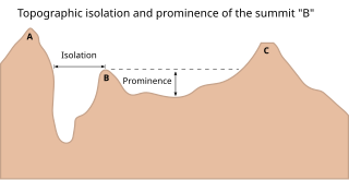
The topographic isolation of a summit is the minimum great-circle distance to a point of equal elevation, representing a radius of dominance in which the peak is the highest point. It can be calculated for small hills and islands as well as for major mountain peaks, and can even be calculated for submarine summits.

Cordillera de la Ramada mountains in Argentina

The Cordillera de la Ramada (Spanish for "Range of the Shelter", also called Cordón de la Ramada, in which cordón means 'ribbon' or 'rope', is a mountain range in the San Juan province of Argentina, forming part of the Andes. Its highest peak is Mercedario at 6,720 metres.

Lists of mountains can be organized by continent and more specifically by country and province/state:

El Waraira Repano National Park

The Waraira Repano National Park protects part of the Cordillera de la Costa Central mountain range, in the coastal region of central-northern Venezuela.

References