
Pico El Yunque or El Yunque Peak is a mountain that is located fully within the boundaries of the El Yunque National Forest, part of the U.S. Forest Service, which is the only tropical rainforest that belongs to the U.S. Forest Service. The peak itself is one of the highest in Puerto Rico, standing at 1,080 meters above sea level. The peak is nearly always covered in thin mist and, due to its high humidity, a quick shower develops during some afternoon. " El Yunque" is the biggest rainforest in the Caribbean. As part of El Yunque there are a few rivers like El Espiritu Santo. It takes almost 4 and a half hours walking to get from Minas Falls to " El Pico ".

Porto Santo Island is a Portuguese island 43 kilometres (27 mi) northeast of Madeira Island in the North Atlantic Ocean; it is the northernmost and easternmost island of the archipelago of Madeira, located in the Atlantic Ocean west of Europe and Africa.

Pico Duarte is the highest peak in the Dominican Republic, and all the Caribbean islands. It is located about 53 miles north-east of the region's lowest point, Lake Enriquillo. The mountain lies in the Cordillera Central range, the greatest of the Dominican Republic's mountain chains. The Cordillera Central extends from the plains between San Cristóbal and Baní to the northwestern peninsula of Haiti, where it is known as Massif du Nord. The highest elevations of the Cordillera Central are found in the Pico Duarte and Valle Nuevo massifs.
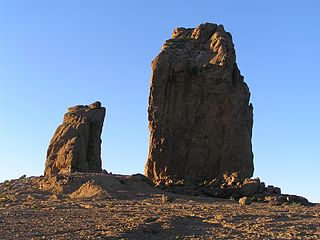
Roque Nublo is a volcanic rock on the island of Gran Canaria, Canary Islands, Spain. It is 67 m (220 ft) tall, and its top is 1,813 m (5,948 ft) above sea level. The Roque Nublo is the third altitude of the island of Gran Canaria, after the Morro de la Agujereada with 1,956 meters, and the Pico de las Nieves with 1,949 meters.

Valverde is a municipality in the Canary Islands in the province of Santa Cruz de Tenerife. It is located on the north-east part of El Hierro. The town of the same name serves as the island's official capital. It is both the smallest Canarian capital and the only one not located by the sea. The town's airport and seaport are both several kilometres away on the island's east coast.

La Frontera is a municipality in the northwestern part of the island El Hierro, Santa Cruz de Tenerife, Canary Islands, Spain. In 2007, the southern part of the territory of La Frontera was split off to form the new municipality of El Pinar.

The El Hierro giant lizard is a subspecies of lacertid that can be found on the island of El Hierro, one of the Canary Islands. It is considered to be a subspecies of Gallotia simonyi, Simony's lizard. The subspecies was once present throughout much of the island and on the small offshore Roque Chico de Salmor, but is now confined to a few small areas of cliff with sparse vegetation. It is currently restricted to the southern end of the Risco de Tibataje in Fuga de Gorreta, located between Guinea and the so-called Paso del Pino. The species was also successfully reintroduced to the Roque Chico de Salmor in 1999, and subsequent reintroductions have taken place at Julan and at la Dehesa.(Miras & Pérez-Mellado 2005b)
The Central System, Spanish and Portuguese: Sistema Central, is one of the main systems of mountain ranges in the Iberian Peninsula. 2,592 m high Pico Almanzor is its highest summit.
El Hierro Airport is an airport located 9 km (5.6 mi) northeast of Valverde. It is the only existing airport on the Island of El Hierro, Spain. It was inaugurated in December 1972 and, officially, it is called Aeropuerto de los Cangrejos.

El Pinar is a Spanish municipality on the island of El Hierro, Canary Islands. It was created in 2007.
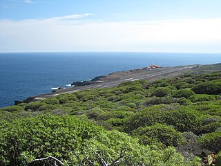
The 2011-2012 El Hierro eruption occurred just off the island of El Hierro, the smallest and farthest south and west of the Canary Islands, in the Atlantic Ocean off the coast of Africa. The island is also the youngest in the volcanic chain. The October 2011 - March 2012 eruption was underwater, with a fissure of vents located approximately 2 km to the south of the fishing village of La Restinga on the southern coast of the island. As of June 2012, increased seismicity to the north-west of the vent suggests another phase in the area's volcanic activity - comprising just deep-seated magma movements with associated earthquakes and deformation of the island at this June 2012 stage - is under way. A second phase of eruptive activity has not yet occurred, and it does not necessarily follow that it will occur.

The Urrieles Massif or the Central Massif is a mountainous massif in the north of Spain, one of the three massifs that make up the Picos de Europa, and in turn, one of the stretches of the Cantabrian Massif belonging to the Cantabrian Range. The other two massifs are the Cornión and Ándara. Of the three, it is the tallest.

Pico de Malpaso is the highest point on the island of El Hierro in the Canary Islands, Spain.


