Pier 26 (San Francisco, California)

Last updated

Coordinates: 37°47′19.47″N122°23′15.74″W / 37.7887417°N 122.3877056°W / 37.7887417; -122.3877056

Geographic coordinate system Coordinate system

A geographic coordinate system is a coordinate system that enables every location on Earth to be specified by a set of numbers, letters or symbols. The coordinates are often chosen such that one of the numbers represents a vertical position and two or three of the numbers represent a horizontal position; alternatively, a geographic position may be expressed in a combined three-dimensional Cartesian vector. A common choice of coordinates is latitude, longitude and elevation. To specify a location on a plane requires a map projection.

Contents

Pier 26 Facade, Port of San Francisco (2010) Pier 26 San Francisco Embarcadro October 2010.jpg
Pier 26 Facade, Port of San Francisco (2010)

The existing historic Pier 26 in San Francisco is located on the Embarcadero with its entrance directly under the San Francisco–Oakland Bay Bridge, several blocks southeast of the Ferry Building. The pier is a single story gable timber structure that rests partially on concrete retainage but mostly on pier foundations on the bay. Its surface area measures approximately 100,000 square feet (9,300 m2), currently used for parking and storage. Its front facade along the Embarcadero is of historic significance.

San Francisco Consolidated city-county in California, US

San Francisco, officially the City and County of San Francisco, is a city in, and the cultural, commercial, and financial center of, Northern California. San Francisco is the 13th-most populous city in the United States, and the fourth-most populous in California, with 883,305 residents as of 2018. It covers an area of about 46.89 square miles (121.4 km2), mostly at the north end of the San Francisco Peninsula in the San Francisco Bay Area, making it the second-most densely populated large US city, and the fifth-most densely populated U.S. county, behind only four of the five New York City boroughs. San Francisco is also part of the fifth-most populous primary statistical area in the United States, the San Jose–San Francisco–Oakland, CA Combined Statistical Area.

Embarcadero (San Francisco) thoroughfare in San Francisco, United States

The Embarcadero is the eastern waterfront and roadway of the Port of San Francisco, San Francisco, California, along San Francisco Bay. It was constructed on reclaimed land along a three mile long engineered seawall, from which piers extend into the bay. It derives its name from the Spanish verb embarcar, meaning "to embark"; embarcadero itself means "the place to embark". The Central Embarcadero Piers Historic District was added to the National Register of Historic Places on November 20, 2002.

San Francisco–Oakland Bay Bridge pair of bridges spanning San Francisco Bay of California, USA

The San Francisco–Oakland Bay Bridge, known locally as the Bay Bridge, is a complex of bridges spanning San Francisco Bay in California. As part of Interstate 80 and the direct road between San Francisco and Oakland, it carries about 260,000 vehicles a day on its two decks. It has one of the longest spans in the United States.

History

By the middle of the 19th century, San Francisco's waterfront was little more than a crumbling mass of abandoned ships and piers. Many of the people who traveled to California to find fame and fortune in the gold rush simply abandoned their boats on the waterfront. In 1863, The Board of State Harbor Commissioners commissioned a sea wall to extend around the San Francisco's bay shore, which exists today as the Embarcadero.

California State of the United States of America

California is a state in the Pacific Region of the United States. With 39.6 million residents, California is the most populous U.S. state and the third-largest by area. The state capital is Sacramento. The Greater Los Angeles Area and the San Francisco Bay Area are the nation's second- and fifth-most populous urban regions, with 18.7 million and 9.7 million residents respectively. Los Angeles is California's most populous city, and the country's second-most populous, after New York City. California also has the nation's most populous county, Los Angeles County, and its largest county by area, San Bernardino County. The City and County of San Francisco is both the country's second-most densely populated major city after New York City and the fifth-most densely populated county, behind only four of the five New York City boroughs.

Gold rush new discovery of gold that brings an onrush of miners seeking their fortune

A Gold Rush is a new discovery of gold—sometimes accompanied by other precious metals and rare earth minerals—that brings an onrush of miners seeking their fortune. Major gold rushes took place in the 19th century in Australia, New Zealand, Brazil, Canada, South Africa and the United States, while smaller gold rushes took place elsewhere.

Pier 26 was developed from existing piers and wharfs at its current location, along with the rest of the Port of San Francisco. After the fire and earthquake of 1906, the piers were modernized and the Port of San Francisco adopted its current system of numbered piers with odd numbered piers to the north of the Ferry Building, and even numbered piers to the south. Pier 26 was leased to the American-Hawaii Steamship Company until the Port fell into disuse in the 1950s. Today, all commercial shipping has moved across the bay to the Port of Oakland, and the pier is now used for parking and storage. [1]

1906 San Francisco earthquake major earthquake that struck San Francisco and the coast of Northern California

The 1906 San Francisco earthquake struck the coast of Northern California at 5:12 a.m. on Wednesday, April 18 with an estimated moment magnitude of 7.9 and a maximum Mercalli intensity of XI (Extreme). High intensity shaking was felt from Eureka on the North Coast to the Salinas Valley, an agricultural region to the south of the San Francisco Bay Area. Devastating fires soon broke out in the city and lasted for several days. As a result, up to 3,000 people died and over 80% of the city of San Francisco was destroyed. The events are remembered as one of the worst and deadliest earthquakes in the history of the United States. The death toll remains the greatest loss of life from a natural disaster in California's history and high in the lists of American disasters.

Port of San Francisco

The Port of San Francisco is a semi-independent organization that oversees the port facilities at San Francisco, California, United States. It is run by a five-member commission, appointed by the Mayor and approved by the Board of Supervisors. The Port is responsible for managing the larger waterfront area that extends from the anchorage of the Golden Gate Bridge, along the Marina district, all the way around the north and east shores of the city of San Francisco including Fisherman's Wharf and the Embarcadero, and southward to the city line just beyond Candlestick Point. In 1968 the State of California, via the California State Lands Commission for the State-operated San Francisco Port Authority, transferred its responsibilities for the Harbor of San Francisco waterfront to the City and County of San Francisco / San Francisco Harbor Commission through the Burton Act AB2649. All eligible State port authority employees had the option to become employees of the City and County of San Francisco to maintain consistent operation of the Port of San Francisco.

San Francisco Ferry Building ferry terminal in San Francisco, California

The San Francisco Ferry Building is a terminal for ferries that travel across the San Francisco Bay, a food hall and an office building. It is located on The Embarcadero in San Francisco, California.

1934 Waterfront Strike

Pier 26 with the San Francisco-Oakland Bay Bridge overhead Bay bridge, embarcadero.jpg
Pier 26 with the San Francisco–Oakland Bay Bridge overhead

During the 1934 West Coast Waterfront Strike the longshoreman's unions organized at Pier 26. The Bloody Thursday riots of July 5, 1934 that killed two union workers occurred outside of Pier 26. Although the strike was perceived by many to be a failure, it helped secure a critical pay raise for the longshoremen during the darkest days of the Great Depression, and cemented the resolve of waterfront unions to protest abuse by their superiors. Each year, the International Longshore and Warehouse Union does not work on July 5 in memory of Bloody Thursday. [2]

Great Depression 20th-century worldwide economic depression

The Great Depression was a severe worldwide economic depression that took place mostly during the 1930s, beginning in the United States. The timing of the Great Depression varied across nations; in most countries it started in 1929 and lasted until the late-1930s. It was the longest, deepest, and most widespread depression of the 20th century. In the 21st century, the Great Depression is commonly used as an example of how intensely the world's economy can decline.

World War II

The San Francisco waterfront piers played a crucial role in the Pacific theater during World War II. With the outbreak of the war, San Francisco's waterfront became a military logistics center; troops, equipment and supplies left the Port in support of the Pacific theater. Almost every pier and wharf was involved in military activities, with troop ships and naval vessels tied up all along the Embarcadero. In addition, the military briefly set up antiaircraft guns and searchlights at piers along the waterfront from 1941 to 1942.

Pacific War theatre of war in the Second World War

The Pacific War, sometimes called the Asia–Pacific War, was the theater of World War II that was fought in the Pacific and Asia. It was fought over a vast area that included the Pacific Ocean and islands, the South West Pacific, South-East Asia, and in China.

World War II 1939–1945 global war

World War II, also known as the Second World War, was a global war that lasted from 1939 to 1945. The vast majority of the world's countries—including all the great powers—eventually formed two opposing military alliances: the Allies and the Axis. A state of total war emerged, directly involving more than 100 million people from over 30 countries. The major participants threw their entire economic, industrial, and scientific capabilities behind the war effort, blurring the distinction between civilian and military resources. World War II was the deadliest conflict in human history, marked by 50 to 85 million fatalities, most of whom were civilians in the Soviet Union and China. It included massacres, the genocide of the Holocaust, strategic bombing, premeditated death from starvation and disease, and the only use of nuclear weapons in war.

Logistics management of the flow of resources

Logistics is generally the detailed organization and implementation of a complex operation. In a general business sense, logistics is the management of the flow of things between the point of origin and the point of consumption in order to meet requirements of customers or corporations. The resources managed in logistics may include tangible goods such as materials, equipment, and supplies, as well as food and other consumable items. The logistics of physical items usually involves the integration of information flow, materials handling, production, packaging, inventory, transportation, warehousing, and often security.

Shelton Studios

In 2006, Executive Director Matthew Shelton leased the historic building to launch film and theater projects. The Shelton Studios was founded by local legend Jean Shelton and Robert Elross, both very active in the Bay Area theater and film communities. Currently Jean Shelton's photo from 1947 graces the main window of Pier 26.

See also

Related Research Articles

Jack London Square Neighborhood of Oakland in Alameda, California, United States

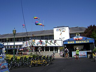
Jack London Square is an entertainment and business destination on the waterfront of Oakland, California, United States. Named after the author Jack London and owned by the Port of Oakland, it is the home of stores, restaurants, hotels, an Amtrak station, a San Francisco Bay Ferry ferry dock, the historic Heinold's First and Last Chance Saloon, the (re-located) cabin where Jack London lived in the Klondike, and a movie theater. A farmer's market is hosted among the retail shops on Sunday mornings. The former presidential yacht USS Potomac is moored at an adjacent slip.

East Bay (San Francisco Bay Area) eastern region of the San Francisco Bay Area, California, US

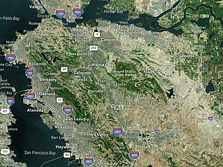
The eastern region of the San Francisco Bay Area, commonly referred to as the East Bay, includes cities along the eastern shores of the San Francisco Bay and San Pablo Bay. The region has grown to include inland communities in Alameda and Contra Costa Counties. With a population of roughly 2.5 million in 2010, it is the most populous subregion in the Bay Area.

Fishermans Wharf, San Francisco Neighborhood of San Francisco in City and County of San Francisco, California, United States

Fisherman's Wharf is a neighborhood and popular tourist attraction in San Francisco, California. It roughly encompasses the northern waterfront area of San Francisco from Ghirardelli Square or Van Ness Avenue east to Pier 35 or Kearny Street. The F Market streetcar runs through the area, the Powell-Hyde cable car lines runs to Aquatic Park, at the edge of Fisherman's Wharf, and the Powell-Mason cable car line runs a few blocks away.

California State Route 480 former highway in California

State Route 480 was a state highway in San Francisco, California, United States, consisting of the elevated double-decker Embarcadero Freeway, the partly elevated Doyle Drive approach to the Golden Gate Bridge and the proposed and unbuilt section in between. The unbuilt section from Doyle Drive to Van Ness Avenue was to have been called the Golden Gate Freeway and the Embarcadero Freeway as originally planned would have extended from Van Ness along the north side of Bay Street and then along the Embarcadero to the San Francisco-Oakland Bay Bridge.

San Francisco Belt Railroad

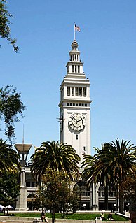
The San Francisco Belt Railroad was a short-line railroad along the Embarcadero in San Francisco, California. It began as the State Belt Railroad in 1889, and was renamed when the city bought the Port of San Francisco in 1969. As a state owned enterprise, the railroad asserted several unsuccessful claims to immunity from federal regulation. The railroad ceased operation in 1993.

Berkeley Pier

The Berkeley Pier is in Berkeley, California. When constructed in 1926, the pier extended 3.5 miles (5.6 km) into San Francisco Bay from the end of University Avenue. Due to extensive filling of the bay and the creation of the Berkeley Marina, it presently extends only 2.5 miles (4.0 km). Since 1937, only the first 3,000 feet (910 m) were maintained and open to the public until July 2015, when public access was closed due to safety concerns.

Hyde Street Pier pier in San Francisco

The Hyde Street Pier, at 2905 Hyde Street, is a historic ferry pier located on the northern waterfront of San Francisco, California, amidst the tourist zone of Fisherman's Wharf.

Berkeley Marina Neighborhood of Berkeley in Alameda, California, United States

The Berkeley Marina is the westernmost portion of the city of Berkeley, California, located west of the Eastshore Freeway at the foot of University Avenue on San Francisco Bay. Narrowly speaking, "Berkeley Marina" refers only to the city marina, but in common usage, it applies more generally to the surrounding area.

West Berkeley is generally the area of Berkeley, California, that lies west of San Pablo Avenue, abutting San Francisco Bay. It includes the area that was once the unincorporated town of Ocean View, as well as the filled-in areas along the shoreline west of I-80, mainly including the Berkeley Marina. It lies at an elevation of 23 feet.

Oakland Long Wharf Former dock in Oakland, California

The Oakland Long Wharf was an 11,000-foot railroad wharf and ferry pier along the east shore of San Francisco Bay located at the foot of Seventh Street in West Oakland. The Oakland Long Wharf was built by the Central Pacific Railroad on what was previously Oakland Point, beginning in 1868. In the 1880s, Southern Pacific Railroad took over the CPRR and rebuilt the pier as the Oakland Mole and Pier.

Ferries of San Francisco Bay

San Francisco Bay in California has been served by ferries of all types for over 150 years. John Reed established a sailboat ferry service in 1826. Although the construction of the Golden Gate Bridge and the San Francisco–Oakland Bay Bridge led to the decline in the importance of most ferries, some are still in use today for both commuters and tourists.

Middle Harbor Shoreline Park public park in Oakland, California, USA

Middle Harbor Shoreline Park (MHSP) is located on San Francisco Bay and the Port of Oakland entrance channel, west of downtown Oakland, California. It is owned and operated by the Port of Oakland. The park entrance is at the intersection of 7th and Middle Harbor Streets. It is open seven days a week from 8 a.m. to dusk.

Central Embarcadero Piers Historic District human settlement in San Francisco, California, United States of America

The Central Embarcadero Piers Historic District is a Registered Historic District in the City of San Francisco, California, United States. It consists of Piers 1, 1½, 3 and 5, is one of the largest surviving pier complexes along San Francisco's Embarcadero. The Central Embarcadero Piers Historic District was added to the National Register of Historic Places on November 20, 2002.

Pier 41

Pier 41 is a ferry terminal on Fisherman's Wharf in San Francisco. The former headquarters of Blue & Gold Fleet, their box offices are now located at Pier 39.

Oakland Point, Oakland, California human settlement in Oakland, California, United States of America

Oakland Point, or Gibbon's Point, was a small promontory formerly on the eastern shore of San Francisco Bay in West Oakland, California. It was located in the vicinity of what is now the Port of Oakland shipping terminal.

Barbary Coast Trail

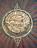
The Barbary Coast Trail is a walking tour connecting 20 historic sites and local history museums in San Francisco, California. Approximately 180 bronze medallions and arrows embedded in the sidewalk mark the 3.8-mile (6.1 km) trail.

Oakland Ferry Terminal

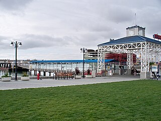
The Oakland Ferry Terminal is a ferry terminal on the San Francisco Bay, located in Jack London Square in Oakland, California.

References

  1. SFGov: Port of San Francisco: History Archived 2007-09-03 at the Wayback Machine .
  2. The Union Takes Hold and the Coming of the Big Strike, 1933–1934