Pigeon River (Huron County, Michigan)

Last updated
Pigeon River
Country United States
Physical characteristics
Main source Sheridan Township, Huron County, Michigan
River mouth Saginaw Bay, Huron County, Michigan
581 ft (177 m) [1]
43°56′45″N83°16′48″W / 43.9458°N 83.2801°W / 43.9458; -83.2801 Coordinates: 43°56′45″N83°16′48″W / 43.9458°N 83.2801°W / 43.9458; -83.2801
Length 38 miles (61 km)

The Pigeon River, also known as the East Branch Pigeon River, is a 37.9-mile-long (61.0 km) [2] stream in Huron County in the Thumb of the U.S. state of Michigan.

Huron County, Michigan County in the United States

Huron County is a county in the U.S. state of Michigan. As of the 2010 United States Census, the population was 33,118. The county seat is Bad Axe. Huron County is at the northern tip of the Thumb, which is a sub region of Mid Michigan. It is a peninsula, bordered by Saginaw Bay to the west and Lake Huron to the north and east, and has over 90 miles (140 km) of shoreline, from White Rock on Lake Huron to Sebewaing on the Saginaw Bay. Huron County's most important industry is agriculture, as with most of the other Thumb counties. Huron County enjoys seasonal tourism from large cities such as Detroit, Flint, and Saginaw.

The Thumb

The Thumb is a region and a peninsula of the U.S. state of Michigan, so named because the Lower Peninsula is shaped like a mitten. The Thumb area is generally considered to be in the Central Michigan region, located east of the Tri-Cities, and north of Metro Detroit. The region is also branded as the Blue Water Area of Michigan.

U.S. state constituent political entity of the United States

In the United States, a state is a constituent political entity, of which there are currently 50. Bound together in a political union, each state holds governmental jurisdiction over a separate and defined geographic territory and shares its sovereignty with the federal government. Due to this shared sovereignty, Americans are citizens both of the federal republic and of the state in which they reside. State citizenship and residency are flexible, and no government approval is required to move between states, except for persons restricted by certain types of court orders. Four states use the term commonwealth rather than state in their full official names.

The stream rises from the confluence of Appin and Livingston drains [1] in southern Sheridan Township. It flows north and west to empty into the Saginaw Bay of Lake Huron in Caseville [1]

Saginaw Bay bay within Lake Huron in eastern Michigan

Saginaw Bay is a bay within Lake Huron located on the eastern side of the U.S. state of Michigan. It forms the space between Michigan's Thumb region and the rest of the Lower Peninsula of Michigan. Saginaw Bay is 1,143 square miles (2,960 km2) in area. It is located in parts of five Michigan counties: Arenac, Bay, Huron, Iosco, and Tuscola.

Lake Huron one of the Great Lakes of North America

Lake Huron is one of the five Great Lakes of North America. Hydrologically, it comprises the easterly portion of Lake Michigan–Huron, having the same surface elevation as its westerly counterpart, to which it is connected by the 5-mile-wide (8.0 km), 20-fathom-deep Straits of Mackinac. It is shared on the north and east by the Canadian province of Ontario and on the south and west by the state of Michigan in the United States. The name of the lake is derived from early French explorers who named it for the Huron people inhabiting the region. The Huronian glaciation was named due to evidence collected from Lake Huron region. The northern parts of the lake include the North Channel and Georgian Bay. Across the lake to the southwest is Saginaw Bay. The main inlet is the St. Marys River, and the main outlet is the St. Clair River.

Caseville, Michigan City in Michigan, United States

Caseville is a city in Huron County in the U.S. state of Michigan, located at the mouth of the Pigeon River on Saginaw Bay of Lake Huron. The population was 777 at the 2010 census. The city is surrounded by Caseville Township. A popular destination for summer tourists, it sponsors the 10-day Cheeseburger in Caseville festival, a tribute to Jimmy Buffett's song "Cheeseburger in Paradise". It has been also called the "Perch Capital of Michigan" for its extraordinary catches of the native fish yellow "perch".

Tributaries

From the mouth:

Related Research Articles

St. Joseph River (Maumee River tributary) tributary of the Maumee River in Ohio and Indiana

The St. Joseph River is an 86.1-mile-long (138.6 km) tributary of the Maumee River in northwestern Ohio and northeastern Indiana in the United States, with headwater tributaries rising in southern Michigan. It drains a primarily rural farming region in the watershed of Lake Erie.

Fawn River (Michigan) river in the United States of America

The Fawn River is a 55.4-mile-long (89.2 km) river in southwest Michigan and northeast Indiana in the United States. It flows into the St. Joseph River in the city of Constantine, Michigan. The headwaters rise in a series of lakes and marshes in northern Steuben County, Indiana near Pokagon State Park, where it is known as "Crooked Creek" and "Little Fawn River". It flows west-northwest across the northeast corner of LaGrange County, Indiana and then over the state line across the southeast corner of Branch County, Michigan before entering St. Joseph County, Michigan. Passing to the south of Sturgis, Michigan, the river meanders across the state line a few more times before flowing north into Constantine. Except for Constantine, the river does not flow through any large communities, although it passes near Fremont, Indiana, Orland, Indiana, Sturgis, Howe, Indiana, and White Pigeon, Michigan.

Bear River (Michigan) small clear slow moving river in the U.S. state of Michigan

Bear River is a small clear slow-moving river in the U.S. state of Michigan. 14.7 miles (23.7 km) long, it is the largest tributary of Little Traverse Bay in the northwest of the lower peninsula. Traverse Bay is on Lake Michigan. The river is formed as the outflow of Walloon Lake on the boundary between Charlevoix County and Emmet County, draining from the southeast end of the lake at 45°15′40″N84°56′01″W near the community of Walloon Lake in Melrose Township. M-75 has its northern terminus in a junction with US 131 nearby.
Pine River (Michigan) Wikimedia disambiguation page

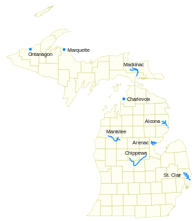
Pine River may refer to any of the following streams in the U.S. state of Michigan:

  1. Pine River. The main branch forms with the confluence of the East and West Branches of the Pine River at 44°29′38″N83°23′16″W in Alcona County. The South Branch joins approximately 1.5 miles (2.4 km) to the south and flows into Iosco County, where it empties into Van Etten Lake at 44°29′38″N83°23′16″W northwest of Oscoda.
  2. Pine River. The main branch is formed by the confluence of the North and Middle Branches northeast of Standish and flows into the Saginaw Bay of Lake Huron at 43°58′32″N83°51′16″W. The South Branch Pine River joins the main stream at 43°59′08″N83°53′17″W.
  3. Pine River is a short waterway, which along with Round Lake, connects Lake Charlevoix with Lake Michigan at Charlevoix.
  4. Pine River rises in Chippewa County and flows south through Mackinac County into the St. Martin Bay of Lake Huron at 46°03′09″N84°39′22″W The North Pine River, also known as the North Branch Pine River, joins at 46°12′20″N84°36′17″W. Another tributary, Hemlock Creek, is also known as Pine River.
  5. Pine River, also known as the South Branch Manistee River, rises in southeast Wexford County, flows southwest across northwest Osceola County, then west and north through the northeast corner of Lake County and back into southwest Wexford County, emptying into the Tippy Dam Pond on the Manistee River at 44°13′37″N85°54′27″W. The main stream is formed from the confluence of the East Branch Pine River with the North Branch Pine River at 44°06′02″N85°31′40″W. Another tributary, the Spaulding Creek, is also known as the Little Pine River
  6. Pine River, in Marquette County, is a very short stream draining Pine Lake into Lake Superior at 46°53′27″N87°52′13″W, north of the Huron Mountains.
  7. Pine River rises in from Pine Lake in eastern Mecosta County, flows mostly south and east through Isabella County, then south along eastern edge of Montcalm County, then east and north through Gratiot County and Midland County, emptying into the Chippewa River at 43°36′06″N84°17′33″W, just about two miles before it joins the Tittabawassee River near Midland. The South Branch Pine River joins the main stream at 43°30′37″N85°00′02″W Another tributary, Miller Creek, is also sometimes known as Pine River or the West Branch Pine River. The North Branch Pine River joins the main stream at 43°26′03″N84°50′18″W.
  8. Pine River empties into the St. Clair River at 42°49′13″N82°29′08″W on the south side of St. Clair. The South Branch Pine River joins the main stream at 42°58′11″N82°37′10″W. Another tributary, Quakenbush Drain, is also sometimes known as Pine River.
  9. Pine Creek empties into Lake Superior and is also known as the Pine River.
Cass River (Michigan) river in the United States of America

The Cass River is a 61.5-mile-long (99.0 km) river in the Thumb region of the U.S. state of Michigan. It drains large portions of Sanilac and Tuscola counties and smaller portions of Genesee, Huron, Lapeer, and Saginaw counties.

Chippewa River (Michigan) river in Michigan

The Chippewa River is a stream in the U.S. state of Michigan that runs 91.8 miles (147.7 km) through the central Lower Peninsula. The Chippewa is a tributary of the Tittabawassee River and is thus part of the Saginaw River drainage basin. The river is named after the Chippewa people.

Carp River is a 40.2-mile-long (64.7 km) river in Chippewa and Mackinac counties in the U.S. state of Michigan. 21.7 miles (34.9 km) of the river were added to the National Wild and Scenic Rivers System in 1992.

Black River (Cheboygan County) tributary of the Cheboygan River in Michigan, United States

Black River is a 78.8-mile-long (126.8 km) river in the U.S. state of Michigan, flowing mostly northward through four Northern Michigan counties: Otsego, Montmorency, Presque Isle, and Cheboygan. The Black River flows into the Cheboygan River at 45°36′13″N84°27′47″W, just south of the city of Cheboygan, and then into Lake Huron. The main branch of the Black River rises in Charlton Township in east-central Otsego County near the boundary with Montmorency County. The East Branch of the Black River rises less than a mile to the east in Vienna Township in Montmorency County. The other major tributaries, Canada Creek, Tomahawk Creek and the Rainy River all rise in northern Montmorency County.
Black River (Southwest Michigan) river in southwest Michigan

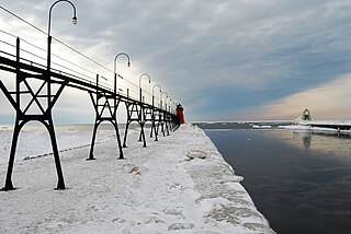
Black River is a 4.2-mile-long (6.8 km) river in the southwest part of the U.S. state of Michigan that empties into Lake Michigan in South Haven at 42°24′08″N86°17′04″W, where it discharges past the South Pier Lighthouse. The river takes its name from the dark brown color of its water, which is caused by suspended sediments and organic materials picked up along its course. The river supports a variety of wildlife including trout, snapping turtles, leeches, and many other varieties of flora and fauna. The Black River watershed encompasses 287 square miles (740 km2) across two counties and 13 townships.

Black River (St. Clair County) tributary of the St. Clair River in Michigan, United States

Black River is an 81.0-mile-long (130.4 km) river in the U.S. state of Michigan, flowing into the St. Clair River in the city of Port Huron. The Black River Canal in northern Port Huron extends east into Lake Huron near Krafft Road.

Cedar River (Gladwin County, Michigan) river in Clare and Gladwin counties, Michigan, United States

The Cedar River is a 29.0-mile-long (46.7 km) river in the U.S. state of Michigan, flowing through Clare County and Gladwin County.

Prairie River (Michigan) river in the United States of America

The Prairie River is a small river that flows 54 miles (87 km) through Branch and St. Joseph counties in Michigan. The river rises at 41°48′20″N85°00′54″W in northern Kinderhook Township in Branch County, and flows west-northwest into the St. Joseph River at 41°54′45″N85°38′21″W just south of the city of Three Rivers, Michigan.

The Kawkawlin River is a 17.5-mile-long (28.2 km) stream in the U.S. state of Michigan that flows into Saginaw Bay of Lake Huron at 43°39′30″N83°53′00″W, approximately 1 mile (1.6 km) west of the mouth of the Saginaw River.

Little Pigeon River may refer to the following streams in the U.S. state of Michigan:

Nottawa Creek is a 33.9-mile-long (54.6 km) stream in the U.S. state of Michigan that flows into the St. Joseph River at 42°00′15″N85°23′40″W, approximately three miles east of the village of Mendon.

Sturgeon River (Cheboygan County, Michigan) river in the U.S. state of Michigan, flowing mostly northward through Otsego and Cheboygan counties

Sturgeon River is a 40.8-mile-long (65.7 km) river in the U.S. state of Michigan, flowing mostly northward through Otsego and Cheboygan counties.

Sturgeon River is a 63.6-mile-long (102.4 km) river in the U.S. state of Michigan, flowing mostly southward through Alger County and Delta County counties on the Upper Peninsula.

Pigeon River may refer to the following streams in the U.S. state of Michigan:

The Little Pigeon River is a 6.0-mile-long (9.7 km) stream in Cheboygan County in the U.S. state of Michigan.

Pine River (Chippewa River) tributary of the Chippewa River in the Lower Peninsula of the U.S. state of Michigan

The Pine River is a 103-mile-long (166 km) river in the Lower Peninsula of the U.S. state of Michigan. The Pine River is a tributary of the Chippewa River and is thus part of the Saginaw River drainage basin.

References

  1. 1 2 3 U.S. Geological Survey Geographic Names Information System: Pigeon River
  2. U.S. Geological Survey. National Hydrography Dataset high-resolution flowline data. The National Map, accessed November 7, 2011
  3. U.S. Geological Survey Geographic Names Information System: Rush Lake Drain
  4. U.S. Geological Survey Geographic Names Information System: Rush Lake
  5. U.S. Geological Survey Geographic Names Information System: Fisher Drain
  6. U.S. Geological Survey Geographic Names Information System: Thompson Drain
  7. U.S. Geological Survey Geographic Names Information System: Van Drain
  8. U.S. Geological Survey Geographic Names Information System: Fluegge Drain
  9. U.S. Geological Survey Geographic Names Information System: Bechler Drain
  10. U.S. Geological Survey Geographic Names Information System: Newman Drain
  11. U.S. Geological Survey Geographic Names Information System: Gorke Drain
  12. U.S. Geological Survey Geographic Names Information System: West Branch Extension
  13. U.S. Geological Survey Geographic Names Information System: Hinton Drain
  14. U.S. Geological Survey Geographic Names Information System: Schultz Drain
  15. U.S. Geological Survey Geographic Names Information System: Hartman Drain
  16. U.S. Geological Survey Geographic Names Information System: Beaubien Drain
  17. U.S. Geological Survey Geographic Names Information System: Little Pigeon River
  18. U.S. Geological Survey Geographic Names Information System: Matthews Drain
  19. U.S. Geological Survey Geographic Names Information System: Mud Lake
  20. U.S. Geological Survey Geographic Names Information System: Huron Drain
  21. 1 2 U.S. Geological Survey Geographic Names Information System: Moore Drain
  22. U.S. Geological Survey Geographic Names Information System: McComb Drain
  23. U.S. Geological Survey Geographic Names Information System: Rawson Drain
  24. U.S. Geological Survey Geographic Names Information System: Crawford Drain
  25. U.S. Geological Survey Geographic Names Information System: Knight Drain
  26. U.S. Geological Survey Geographic Names Information System: Muntz Drain
  27. U.S. Geological Survey Geographic Names Information System: Blair Drain
  28. U.S. Geological Survey Geographic Names Information System: Clift Drain
  29. U.S. Geological Survey Geographic Names Information System: Jordan Drain
  30. U.S. Geological Survey Geographic Names Information System: Elk Drain
  31. U.S. Geological Survey Geographic Names Information System: Patterson Drain
  32. U.S. Geological Survey Geographic Names Information System: Appin Drain
  33. U.S. Geological Survey Geographic Names Information System: Shier Drain
  34. U.S. Geological Survey Geographic Names Information System: North Branch Shier Drain
  35. U.S. Geological Survey Geographic Names Information System: Reid Drain
  36. U.S. Geological Survey Geographic Names Information System: Livingston Drain