Related Research Articles

The Au Sable River in Michigan, United States runs approximately 138 miles (222 km) through the northern Lower Peninsula, through the towns of Grayling and Mio, and enters Lake Huron at the town of Oscoda. It is considered one of the best brown trout fisheries east of the Rockies and has been designated a blue ribbon trout stream by the Michigan Department of Natural Resources. A map from 1795 located in the United States Gazetteer calls it the Beauais River. In French, the river is called the Rivière au sable, literally "Sand River".

The Kalamazoo River is a river in the U.S. state of Michigan. The river is 130 miles (210 km) long from the junction of its North and South branches to its mouth at Lake Michigan, with a total length extending to 178 miles (286 km) when one includes the South Branch. The river's watershed drains an area of approximately 2,020 square miles (5,200 km2) and drains portions of eight counties in southwest Michigan: Allegan, Barry, Eaton, Van Buren, Kalamazoo, Calhoun, Jackson, Hillsdale, Kent and Ottawa. The river has a median flow of 1,863 cubic feet per second (52.8 m3/s) at New Richmond, upstream from its mouth at Saugatuck and Douglas.

The St. Joseph River is an 86.1-mile-long (138.6 km) tributary of the Maumee River in northwestern Ohio and northeastern Indiana in the United States, with headwater tributaries rising in southern Michigan. It drains a primarily rural farming region in the watershed of Lake Erie.

The Fawn River is a 55.4-mile-long (89.2 km) river in southwest Michigan and northeast Indiana in the United States. It flows into the St. Joseph River in the city of Constantine, Michigan. The headwaters rise in a series of lakes and marshes in northern Steuben County, Indiana near Pokagon State Park, where it is known as "Crooked Creek" and "Little Fawn River". It flows west-northwest across the northeast corner of LaGrange County, Indiana and then over the state line across the southeast corner of Branch County, Michigan before entering St. Joseph County, Michigan. Passing to the south of Sturgis, Michigan, the river meanders across the state line a few more times before flowing north into Constantine. Except for Constantine, the river does not flow through any large communities, although it passes near Fremont, Indiana, Orland, Indiana, Sturgis, Howe, Indiana, and White Pigeon, Michigan.

Called Mes-kwah-wa-se-pe or "old redwood creek" by Native Americans, Cedar Creek is the largest tributary of the St. Joseph River, draining 174,780 acres (707.3 km2) in the Eastern Corn Belt Plains of northeastern Indiana. It is 31.9 miles (51.3 km) long, rising in northwestern DeKalb County and joining the St. Joseph just below the Cedarville Dam in Allen County.
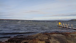
Burt Lake is a 17,120 acre (69 km2) lake in Cheboygan County in the U.S. state of Michigan. The western shore of the lake is on the boundary with Emmet County. The lake is named after William Austin Burt, who, together with John Mullett, made a federal survey of the area from 1840 to 1843.

Mullett Lake is a lake in Cheboygan County in the U.S. state of Michigan. The lake is named after John Mullett, who, together with William A. Burt, made a federal survey of the area from 1840 to 1843. A neighboring lake was named after Burt. Historically, Mullett Lake has been recorded as Mullet Lake, Mullet's Lake, and Mullett's Lake on maps and documents.

Pine River may refer to any of the following rivers in the U.S. state of Michigan:

Black River is a 78.8-mile-long (126.8 km) river in the U.S. state of Michigan, flowing mostly northward through four Northern Michigan counties: Otsego, Montmorency, Presque Isle, and Cheboygan. The Black River flows into the Cheboygan River at 45°36′13″N84°27′47″W, just south of the city of Cheboygan, and then into Lake Huron. The main branch of the Black River rises in Charlton Township in east-central Otsego County near the boundary with Montmorency County. The East Branch of the Black River rises less than a mile to the east in Vienna Township in Montmorency County. The other major tributaries, Canada Creek, Tomahawk Creek and the Rainy River all rise in northern Montmorency County.
The Galien River is a 30.0-mile-long (48.3 km) stream in the southwest region of the U.S. state of Michigan. The river begins at the outlet of Dayton Lake and flows in a predominantly westerly direction until it enters southeastern Lake Michigan at New Buffalo. The South Branch Galien River rises just north of the border with Indiana, at the confluence of Spring Creek and the Galena River, the latter rising in LaPorte County, Indiana.

The Cheboygan River is a short but significant river in the Lake Huron drainage basin of the U.S. state of Michigan.
Cedar Creek may refer to several small streams in the U.S. state of Michigan:
Little Pigeon River may refer to the following streams in the U.S. state of Michigan:

Sturgeon River is a 40.8-mile-long (65.7 km) river in the U.S. state of Michigan, flowing mostly northward through Otsego and Cheboygan counties.

Indian River in the Lower Peninsula of Michigan is a 3.9-mile-long (6.3 km) waterway in Cheboygan County flowing from Burt Lake at 45°24′37″N84°37′19″W to Mullett Lake at 45°27′05″N84°34′39″W. The unincorporated community of Indian River is named after the river.
The Little Pigeon River is a 6.0-mile-long (9.7 km) stream in Cheboygan County in the U.S. state of Michigan.
The Little Pigeon River is a 10.2-mile-long (16.4 km) stream in Otsego and Cheboygan counties in the U.S. state of Michigan.
The Pigeon River, also known as the East Branch Pigeon River, is a 37.9-mile-long (61.0 km) stream in Huron County in the Thumb of the U.S. state of Michigan.

The Pigeon River is a small river flowing to Lake Michigan on the western Lower Peninsula of the U.S. state of Michigan. The river is approximately 12.9 miles (20.8 km) long and drains an area of 61.7 square miles (160 km2) in a generally rural area situated between the cities of Holland and Grand Haven. Via Lake Michigan and the larger Great Lakes system, it is part of the watershed of the St. Lawrence River.
References
- ↑ U.S. Geological Survey Geographic Names Information System: Pigeon River (Lake Huron)
- ↑ U.S. Geological Survey Geographic Names Information System: Pigeon River (Mullett Lake)
- ↑ U.S. Geological Survey Geographic Names Information System: South Branch Pigeon River
- ↑ U.S. Geological Survey Geographic Names Information System: Pigeon River (Lake Michigan)
- ↑ U.S. Geological Survey Geographic Names Information System: Pigeon River (St. Joseph River)
If an internal link incorrectly led you here, you may wish to change the link to point directly to the intended article.