The Muskegon River is a 216-mile-long (348 km) river in the Lower Peninsula of the U.S. state of Michigan. From its source at Houghton Lake in Roscommon County, the river flows in a generally southwesterly direction to its mouth at Lake Michigan at the eponymous city of Muskegon. The river drains an area of 2,350 square miles (6,100 km2), and collects a number of tributaries, including the Little Muskegon River, Hersey River, and Clam River.

The Calumet River is a system of heavily industrialized rivers and canals in the region between the south side of Chicago, Illinois, and the city of Gary, Indiana. Historically, the Little Calumet River and the Grand Calumet River were one, the former flowing west from Indiana into Illinois, then turning back east to its mouth at Lake Michigan at Marquette Park in Gary. Now the system is part of the Chicago Area Waterway System and through the use of locks flows away from Lake Michigan to the Cal-Sag Channel.

The Red Cedar River is a 51.1-mile-long (82.2 km) river in the U.S. state of Michigan. The river, which is a tributary of the Grand River in Michigan's Lower Peninsula, drains a watershed of approximately 461 square miles (1,190 km2) in the Lansing–East Lansing metropolitan area and suburban and rural areas to the east. The river flows through the campus of Michigan State University, and is considered a cultural symbol of the school, including being mentioned in the school's fight song.
The Battle Creek River is a river in the U.S. state of Michigan. It is a tributary of the Kalamazoo River, joining it at Battle Creek, Michigan; the Kalamazoo River empties into Lake Michigan.
The Paw Paw River is located in the U.S. state of Michigan in the southwest portion of the lower peninsula. It is formed by the confluence of the north and south branches at 42°15′17″N85°55′36″W in Waverly Township in the northeast of Van Buren County. It flows approximately 61.8 miles (99.5 km) through Van Buren County and Berrien County until joining the St. Joseph River just above its mouth on Lake Michigan at Benton Harbor.

The Rabbit River is a 62.1-mile-long (99.9 km) tributary of the Kalamazoo River within Allegan County in the U.S. state of Michigan. The river's watershed covers 187,200 acres (758 km2) of land and drains most of north-central and northeast Allegan County as well as small portions of Barry, Kent and Ottawa counties.
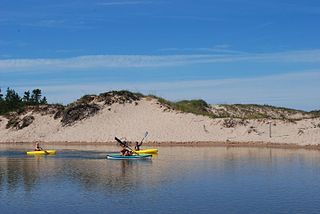
The Platte River is a 29.5-mile-long (47.5 km) river in the northwestern Lower Peninsula of Michigan. Beginning at Long Lake in Grand Traverse County, the Platte River flows west across Benzie County before ending at Platte Bay, a small bay of Lake Michigan, in the Sleeping Bear Dunes National Lakeshore. The river drains an area of about 193 square miles (500 km2).

The Dowagiac River is a southwesterly flowing 30.9-mile-long (49.7 km) stream in the Lower Peninsula of the U.S. state of Michigan. It is a tributary to the St. Joseph River which flows, in turn, into eastern Lake Michigan.

The Rocky River is a 28.3-mile-long (45.5 km) stream located in the southwest part of the U.S. state of Michigan that flows into the St. Joseph River at 41°56′33″N85°37′59″W in the city of Three Rivers in St. Joseph County. The Rocky River, along with the St. Joseph River and the Portage River, are the three rivers from which the city of Three Rivers takes its name.

The Coldwater River is a 19.4-mile-long (31.2 km) stream in the U.S. state of Michigan. Located in western Michigan, the river is a part of the Grand River drainage basin.

The Galien River is a 30.0-mile-long (48.3 km) stream in the southwest region of the U.S. state of Michigan. The river begins at the outlet of Dayton Lake and flows in a predominantly westerly direction until it enters southeastern Lake Michigan at New Buffalo. The South Branch Galien River rises just north of the border with Indiana, at the confluence of Spring Creek and the Galena River, the latter rising in LaPorte County, Indiana.

The Prairie River is a small river that flows 54 miles (87 km) through Branch and St. Joseph counties in Michigan. The river rises at 41°48′20″N85°00′54″W in northern Kinderhook Township in Branch County, and flows west-northwest into the St. Joseph River at 41°54′45″N85°38′21″W just south of the city of Three Rivers, Michigan.

The Ocqueoc River is a 34.2-mile-long (55.0 km) blackwater river in the U.S. state of Michigan. The river is located in the northeastern Lower Peninsula, flowing into Lake Huron in Presque Isle County. The river drains a watershed of approximately 94,394 acres (382.00 km2). Along the river are the Ocqueoc Falls, the largest and only named waterfall in Michigan's Lower Peninsula.

The Charlotte River is a tributary of the St. Marys River in the state of Michigan in the United States. The stream is 17.1 miles (27.5 km) long and drains an area of 58.4 square miles (151 km2) on the eastern Upper Peninsula. Via the St. Marys River, it is part of the watershed of Lake Huron. Via Lake Huron and the Great Lakes system, it is part of the larger watershed of the St. Lawrence River.
The Galena River is an 8.5-mile-long (13.7 km) stream in northern Indiana in the United States. It rises in the northeast corner of Springfield Township, about 5 miles (8 km) north of LaPorte in LaPorte County and flows northeast. Just after it crosses the state boundary into Three Oaks Township in Berrien County, Michigan, it is joined from the east by Spring Creek to form the South Branch Galien River. After becoming the Galien River in Michigan, the river ultimately flows to Lake Michigan in New Buffalo.
The Pinconning River is a small river on the central Lower Peninsula of Michigan in the United States. It is 15.6 miles (25.1 km) long and flows to Saginaw Bay of Lake Huron, draining an area of 26.6 square miles (69 km2). Via Lake Huron and the Great Lakes system, it is part of the larger watershed of the St. Lawrence River.
Little Thornapple River is a 5.8-mile-long (9.3 km) river in Barry County in the U.S. state of Michigan.

Misteguay Creek is a tributary of the Flint River, 38.4 miles (61.8 km) long, on the central Lower Peninsula of Michigan in the United States. The stream drains an area of 174.4 square miles (452 km2) in predominantly agricultural areas of the Flint/Tri-Cities region. Via the Flint and Shiawassee rivers, it is part of the watershed of the Saginaw River, which flows to Saginaw Bay of Lake Huron. Via Lake Huron and the Great Lakes system, it is part of the larger watershed of the St. Lawrence River.

Sycamore Creek is a tributary of the Red Cedar River in the state of Michigan in the United States. The stream is 26.5 miles (42.6 km) long and drains an area of 106.1 square miles (275 km2) on the central Lower Peninsula, in and around the city of Lansing. Via the Red Cedar River, it is part of the watershed of the Grand River, which flows to Lake Michigan. Via Lake Michigan and the Great Lakes system, it is part of the larger watershed of the St. Lawrence River.

Dunes Creek is a northwards-flowing 4.3-mile-long (6.9 km) stream which drains the Great Marsh of Indiana Dunes State Park and Indiana Dunes National Park in Porter County, Indiana, United States. Dunes Creek passes through the coastal sand dunes to empty into Lake Michigan.