Rutland Charter Township is a charter township of Barry County in the U.S. state of Michigan. The population was 4,136 at the 2020 census.

Wayne Township is a civil township of Cass County in the U.S. state of Michigan. The population was 2,576 at the 2020 census.

Blair Township is a civil township of Grand Traverse County in the U.S. state of Michigan. As of the 2020 census, the township had a population of 8,994, an increase from 8,209 at the 2010 census. The township lies about 4 miles (6.4 km) south of Traverse City, the largest city in Northern Michigan. Because of this proximity, much of the north of Blair Township is developed, especially within the township-administered communities of Chums Corner and Grawn, while much of the south of the township is rural in nature.

Long Lake Township, officially the Charter Township of Long Lake, is a charter township of Grand Traverse County in the U.S. state of Michigan. The population was 9,956 at the 2020 census, an increase from 8,662 at the 2010 census.

Elba Township is a civil township of Gratiot County in the U.S. state of Michigan. The population was 1,293 at the 2020 census.

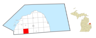
Brookfield Township is a civil township of Huron County in the U.S. state of Michigan. As of the 2020 census, the township population was 739.
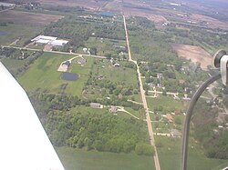
Grant Township is a civil township of Huron County in the U.S. state of Michigan. As of the 2020 census, the township population was 869.
Easton Township is a civil township of Ionia County in the U.S. state of Michigan. The population was 3,058 at the 2020 census.

Keene Township is a civil township of Ionia County in the U.S. state of Michigan. The population was 1,730 at the 2020 census.
Orange Township is a civil township of Ionia County in the U.S. state of Michigan. The population was 1,012 at the 2020 census.

Parma Township is a civil township of Jackson County in the U.S. state of Michigan. The population was 2,668 at the 2020 census.

Ellsworth Township is a civil township of Lake County in the U.S. state of Michigan. The population was 736 at the 2020 census.

Rollin Township is a civil township of Lenawee County in the U.S. state of Michigan. The population was 3,035 at the 2020 census.
Dalton Township is a civil township of Muskegon County in the U.S. state of Michigan. As of the 2020 census, the township population was 9,427.
Big Prairie Township is a civil township of Newaygo County in the U.S. state of Michigan. As of the 2020 census, the township population was 2,436.
Brooks Township is a civil township of Newaygo County in the U.S. state of Michigan. As of the 2020 census, the township population was 3,705.
Ensley Township is a civil township of Newaygo County in the U.S. state of Michigan. The population was 2,603 at the 2020 census.

Polkton Charter Township is a charter township of Ottawa County in the U.S. state of Michigan. The population was 2,565 at the 2020 census. It was organized in 1845.
Park Township is a civil township of St. Joseph County in the U.S. state of Michigan. The population was 2,397 at the 2020 census.

Hamilton Township is a civil township of Van Buren County in the U.S. state of Michigan. As of the 2020 census, the township population was 1,370.