Ottawa County is a county located in the U.S. state of Michigan. As of the United States 2020 Census, the population was 296,200. The county seat is Grand Haven. The county is named for the Ottawa Nation. It was set off in 1831 and organized in 1837. Ottawa County is included in the Grand Rapids-Kentwood, MI Metropolitan Statistical Area and has a significant Dutch American population.

Muskegon County is a county in the U.S. state of Michigan. As of 2020, the population was 175,824. The county seat is Muskegon.

Kent County is located in the U.S. state of Michigan. As of the 2020 Census, the county had a population of 657,974, making it the fourth most populous county in Michigan, and the largest outside of the Detroit area. Its county seat is Grand Rapids. The county was set off in 1831, and organized in 1836. It is named for New York jurist and legal scholar James Kent, who represented the Michigan Territory in its dispute with Ohio over the Toledo Strip.

Alpine Township is a civil township of Kent County in the U.S. state of Michigan. The population was 14,079 at the 2020 census.
Casnovia Township is a civil township of Muskegon County in the U.S. state of Michigan. The population was 2,793 at the 2020 census.
Moorland Township is a civil township of Muskegon County in the U.S. state of Michigan. The population was 1,627 at the 2020 census.
Norton Shores is a city in Muskegon County in the U.S. state of Michigan. The population was 25,030 at the 2020 census.

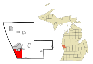
Ravenna is a village in Muskegon County in the U.S. state of Michigan. The population was 1,308 at the 2020 census. The village is located in Ravenna Township.
Ravenna Township is a civil township of Muskegon County in the U.S. state of Michigan. As of the 2020 census, the population was 2,962, up from 2,905 in 2010. The village of Ravenna is located within the township.
Sullivan Township is a civil township of Muskegon County in the U.S. state of Michigan. As of the 2020 census, the township population was 2,541.

Allendale Charter Township is a charter township of Ottawa County in the U.S. state of Michigan. At the 2020 Census, the township population was 26,582. Allendale Charter Township is best known as being home to the main campus of Grand Valley State University.

Spring Lake Township is a civil township of Ottawa County in the U.S. state of Michigan. The population was 15,296 according to the 2020 census, up from 14,300 according to the 2010 census. The village of Spring Lake is located within the township.

Wright Township is a civil township of Ottawa County in the U.S. state of Michigan. The population was 3,190 at the 2020 census.

Coopersville is a city located in north central Ottawa County in the U.S. state of Michigan. The population was 4,828 at the 2020 census. It is primarily a farming community.

Crockery Township is a civil township of Ottawa County in the U.S. state of Michigan. As of the 2020 census, the township population was 4,572.

West Michigan and Western Michigan are terms for a region in the U.S. state of Michigan's Lower Peninsula. Generally, it refers to the Grand Rapids-Muskegon-Holland area, and more broadly to most of the region along the Lower Peninsula's Lake Michigan shoreline, but there is no official definition.

Nunica is an unincorporated community in the U.S. state of Michigan. The community is located near the center of Crockery Township in Ottawa County, close to the junction of Interstate 96 (I-96) M-104 and M-231 at 43°04′47″N86°04′02″W. The first white settlers were Manley Patchin in 1836 and William Hathaway, Jr., in 1839. Hathaway became the first postmaster of Crockery Creek on February 7, 1848. The name of the post office was changed to Nunica on January 8, 1859. The settlement was first platted by Henry Ernst in 1865. The name Nunica is derived from the Native American word menonica, meaning "clay earth", from which pottery was made. This clay was also the origin for the name of Crockery Creek. The Nunica ZIP code 49448 serves most of Crockery Township, as well as portions of Sullivan Township in Muskegon County to the north and small areas of Polkton Township to the east.
Michigan's 3rd congressional district is a U.S. congressional district in West Michigan. From 2003 to 2013, it consisted of the counties of Barry and Ionia, as well as all except the northwestern portion of Kent, including the city of Grand Rapids. In 2012 redistricting, the district was extended to Battle Creek. In 2022, the district was condensed to the greater Grand Rapids and Muskegon areas, including portions of Kent, Muskegon, and Ottawa counties. Redistricting removed Barry, Calhoun, and Ionia counties.

The Grand Rapids metropolitan area is a triangular shaped Metro Triplex, in West Michigan, which fans out westward from the primary hub city of Grand Rapids, Michigan, to the other two metro hubs of Muskegon and Holland. The metropolitan area had an estimated population of 1,059,113 in 2017. The region, noted in particular for its western edge abutting the Lake Michigan shoreline and its beaches, is a popular tourist and vacation destination during the summer. Noted popular metro area beach towns include Grand Haven, Holland, Muskegon, and Saugatuck.
Maple Valley Township is a civil township of Montcalm County in the U.S. state of Michigan. The population was 1,908 at the 2020 census.