Casnovia, Michigan

Last updated

Casnovia, Michigan
Kent County Michigan Incorporated and Unincorporated areas Casnovia Highlighted.svg
Location of Casnovia in Kent County and the state of Michigan
Coordinates: 43°14′5″N85°47′18″W / 43.23472°N 85.78833°W / 43.23472; -85.78833
Country United States
State Michigan
Counties Kent, Muskegon
Townships Tyrone, Casnovia
Area
[1]
  Total1.07 sq mi (2.78 km2)
  Land1.06 sq mi (2.75 km2)
  Water0.01 sq mi (0.02 km2)
Elevation
899 ft (274 m)
Population
 (2020) [2]
  Total316
  Density297.27/sq mi (114.80/km2)
Time zone UTC-5 (Eastern (EST))
  Summer (DST) UTC-4 (EDT)
ZIP code
49318
Area code 616
FIPS code 26-13820 [3]
GNIS feature ID0622844 [4]

Casnovia is a village in the U.S. state of Michigan. It is situated on the boundary between Muskegon and Kent counties and lies partially within each. The population was 316 at the 2020 census. [2]

Contents

History

Casnovia was founded in 1850 by Lot Fulkerson and gained a post office in 1851. It was platted in 1862 and incorporated as a village in 1875. The name is derived from the Latin words case for home and nova for new. [5]

Geography

The village is in western Michigan, in the eastern part of Muskegon County and the northwest part of Kent County. The village is in eastern Casnovia Township and western Tyrone Township. The village's Main Street, running north-south, follows the county line. State highways M-46 and M-37 pass together through the southern part of the village, leading southeast 2 miles (3 km) to Kent City. M-37 leads south 22 miles (35 km) to Grand Rapids and north 14 miles (23 km) to Newaygo, while M-46 leads west 23 miles (37 km) to Muskegon and east 12 miles (19 km) to Cedar Springs.

According to the U.S. Census Bureau, Casnovia has a total area of 1.07 square miles (2.77 km2), of which 0.01 square miles (0.03 km2), or 0.84%, are water. [1]

Demographics

Historical population
CensusPop.Note
1880 196
1890 27540.3%
1900 2770.7%
1910 30811.2%
1920 3338.1%
1930 254−23.7%
1940 28913.8%
1950 3128.0%
1960 37118.9%
1970 4038.6%
1980 348−13.6%
1990 3768.0%
2000 315−16.2%
2010 3191.3%
2020 316−0.9%
U.S. Decennial Census [6]

2010 census

As of the census [7] of 2010, there were 319 people, 121 households, and 94 families living in the village. The population density was 295.4 inhabitants per square mile (114.1/km2). There were 131 housing units at an average density of 121.3 per square mile (46.8/km2). The racial makeup of the village was 88.4% White, 0.3% African American, 1.9% Native American, 4.4% from other races, and 5.0% from two or more races. Hispanic or Latino of any race were 11.6% of the population.

There were 121 households, of which 28.1% had children under the age of 18 living with them, 65.3% were married couples living together, 7.4% had a female householder with no husband present, 5.0% had a male householder with no wife present, and 22.3% were non-families. 15.7% of all households were made up of individuals, and 3.3% had someone living alone who was 65 years of age or older. The average household size was 2.64 and the average family size was 2.97.

The median age in the village was 41.9 years. 22.3% of residents were under the age of 18; 8.6% were between the ages of 18 and 24; 23.8% were from 25 to 44; 32.3% were from 45 to 64; and 12.9% were 65 years of age or older. The gender makeup of the village was 50.8% male and 49.2% female.

2000 census

As of the census [3] of 2000, there were 315 people, 122 households, and 91 families living in the village. The population density was 287.6 inhabitants per square mile (111.0/km2). There were 126 housing units at an average density of 115.0 per square mile (44.4/km2). The racial makeup of the village was 98.73% White, 0.32% Native American, and 0.95% from two or more races. Hispanic or Latino of any race were 0.32% of the population.

There were 122 households, out of which 33.6% had children under the age of 18 living with them, 60.7% were married couples living together, 8.2% had a female householder with no husband present, and 25.4% were non-families. 19.7% of all households were made up of individuals, and 8.2% had someone living alone who was 65 years of age or older. The average household size was 2.58 and the average family size was 2.98.

In the village, the population was spread out, with 25.4% under the age of 18, 8.6% from 18 to 24, 33.3% from 25 to 44, 21.9% from 45 to 64, and 10.8% who were 65 years of age or older. The median age was 35 years. For every 100 females, there were 107.2 males. For every 100 females age 18 and over, there were 99.2 males.

The median income for a household in the village was $42,019, and the median income for a family was $47,188. Males had a median income of $36,563 versus $26,250 for females. The per capita income for the village was $18,962. About 1.2% of families and 4.7% of the population were below the poverty line, including 5.8% of those under age 18 and 5.1% of those age 65 or over.

Notable people

Related Research Articles

Grant Township is a civil township of Mecosta County in the U.S. state of Michigan. As of the 2020 census, the township population was 702.

<span class="mw-page-title-main">Mecosta, Michigan</span> Village in Michigan, United States

Mecosta is a village in Mecosta County in the U.S. state of Michigan. The population was 386 at the 2020 census, down from 457 in 2010. The village is within Morton Township. Mecosta Township, which is also in Mecosta County, is located several miles to the west.

Cato Township is a civil township of Montcalm County in the U.S. state of Michigan. The population was 2,898 at the 2020 census.

<span class="mw-page-title-main">Lakeview, Michigan</span> Village in Michigan, United States

Lakeview is a village in Cato Township in Montcalm County of the U.S. state of Michigan. The population was 1,024 at the 2020 census.

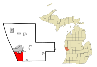
Reynolds Township is a civil township of Montcalm County in the U.S. state of Michigan. The population was 5,431 at the 2020 census.

Casnovia Township is a civil township of Muskegon County in the U.S. state of Michigan. The population was 2,793 at the 2020 census.

Egelston Township is a general law township of Muskegon County in the U.S. state of Michigan. As of the 2020 census, the township population was 11,128, up from 9,909 in 2010.

Fruitland Township is a civil township of Muskegon County in the U.S. state of Michigan. The population was 5,793 at the 2020 census.

<span class="mw-page-title-main">Fruitport, Michigan</span> Village in Michigan, United States

Fruitport is a village in Muskegon County in the U.S. state of Michigan. The population was 1,103 at the 2020 census. The community is located within Fruitport Charter Township.

<span class="mw-page-title-main">Lakewood Club, Michigan</span> Village in Michigan, United States

Lakewood Club is a village in Dalton Township of Muskegon County in the U.S. state of Michigan. The population was 1,340 at the 2020 census.

<span class="mw-page-title-main">Montague, Michigan</span> City in Michigan, United States

Montague is a city in Muskegon County in the U.S. state of Michigan. The population was 2,417 at the 2020 census. The city is politically independent from Montague Township, which borders it on three sides.

Montague Township is a civil township of Muskegon County in the U.S. state of Michigan. The population was 1,555 at the 2020 census. It is adjacent to the city of Montague.

<span class="mw-page-title-main">Muskegon Heights, Michigan</span> City in Michigan, United States

Muskegon Heights is a city in Muskegon County in the U.S. state of Michigan. The population was 9,985 at the 2020 census.

<span class="mw-page-title-main">North Muskegon, Michigan</span> City in Michigan, United States

North Muskegon is a city in Muskegon County in the U.S. state of Michigan. The population was 4,093 at the 2020 census, up from 3,786 in 2010.

<span class="mw-page-title-main">Norton Shores, Michigan</span> City in Michigan, United States

Norton Shores is a city in Muskegon County in the U.S. state of Michigan. The population was 25,030 at the 2020 census.

<span class="mw-page-title-main">Ravenna, Michigan</span> Village in Michigan, United States

Ravenna is a village in Muskegon County in the U.S. state of Michigan. The population was 1,308 at the 2020 census. The village is located in Ravenna Township.

Ravenna Township is a civil township of Muskegon County in the U.S. state of Michigan. As of the 2020 census, the population was 2,962, up from 2,905 in 2010. The village of Ravenna is located within the township.

Sullivan Township is a civil township of Muskegon County in the U.S. state of Michigan. As of the 2020 census, the township population was 2,541.

Spring Lake Township is a civil township of Ottawa County in the U.S. state of Michigan. The population was 13,140 according to the 2000 census and 14,300 according to the 2010 census. The village of Spring Lake is located within the township.

<span class="mw-page-title-main">Exeter, Wisconsin</span> Town in Wisconsin, United States

Exeter is a town in Green County, Wisconsin, United States. The population was 1,261 at the 2000 census. The unincorporated communities of Dayton and Ross Crossing are located in the town.

References

Notes

  1. 1 2 "2023 U.S. Gazetteer Files: Michigan". United States Census Bureau. Retrieved December 18, 2023.
  2. 1 2 "P1. Race – Casnovia village, Michigan: 2020 DEC Redistricting Data (PL 94-171)". U.S. Census Bureau. Retrieved December 18, 2023.
  3. 1 2 "U.S. Census website". United States Census Bureau . Retrieved January 31, 2008.
  4. "US Board on Geographic Names". United States Geological Survey. October 25, 2007. Retrieved January 31, 2008.
  5. Romig 1986, p. 102.
  6. "Census of Population and Housing". Census.gov. Retrieved June 4, 2015.
  7. "U.S. Census website". United States Census Bureau . Retrieved November 25, 2012.

Sources

43°14′05″N85°47′26″W / 43.23472°N 85.79056°W / 43.23472; -85.79056