North Muskegon, Michigan

Last updated
North Muskegon, Michigan
Muskegon County Michigan Incorporated and Unincorporated areas North Muskegon Highlighted.svg
Location in Muskegon County and the state of Michigan
Coordinates: 43°15′22″N86°16′03″W / 43.25611°N 86.26750°W / 43.25611; -86.26750
Country United States
State Michigan
County Muskegon
Government
  Type Council-manager
   Mayor Sabina Freeman
   City Manager Sam Janson
Area
[1]
  Total4.12 sq mi (10.67 km2)
  Land1.79 sq mi (4.63 km2)
  Water2.33 sq mi (6.03 km2)
Elevation
620 ft (189 m)
Population
 (2020) [2]
  Total4,093
  Density2,286.59/sq mi (883.07/km2)
Time zone UTC-5 (Eastern (EST))
  Summer (DST) UTC-4 (EDT)
ZIP code
49445
Area code 231
FIPS code 26-58640 [3]
GNIS feature ID1621049 [4]
Website www.northmuskegon.org

North Muskegon is a city in Muskegon County in the U.S. state of Michigan. The population was 4,093 at the 2020 census, [2] up from 3,786 in 2010.

Contents

Geography

The city is in western Muskegon County on the north side of Muskegon Lake, an arm of Lake Michigan. It is bordered to the south, across the lake, by the city of Muskegon, the county seat. The Muskegon River flows into Muskegon Lake in the eastern part of the city. The lake's outlet channel to Lake Michigan is a mile west of the city limits.

According to the U.S. Census Bureau, North Muskegon has a total area of 4.12 square miles (10.67 km2), of which 1.79 square miles (4.64 km2) are land and 2.33 square miles (6.03 km2), or 56.5%, are water. [5]

Demographics

Historical population
CensusPop.Note
1890 1,590
1900 513−67.7%
1910 352−31.4%
1920 63079.0%
1930 1,370117.5%
1940 1,69423.6%
1950 2,42443.1%
1960 3,85559.0%
1970 4,24310.1%
1980 4,024−5.2%
1990 3,919−2.6%
2000 4,0312.9%
2010 3,786−6.1%
2020 4,0938.1%
U.S. Decennial Census [6]

2010 census

As of the census [7] of 2010, there were 3,786 people, 1,621 households, and 1,069 families living in the city. The population density was 2,151.1 inhabitants per square mile (830.5/km2). There were 1,834 housing units at an average density of 1,042.0 per square mile (402.3/km2). The racial makeup of the city was 94.6% White, 2.1% African American, 0.6% Native American, 0.7% Asian, 0.1% Pacific Islander, 0.2% from other races, and 1.8% from two or more races. Hispanic or Latino of any race were 2.4% of the population.

There were 1,621 households, of which 29.2% had children under the age of 18 living with them, 51.9% were married couples living together, 11.4% had a female householder with no husband present, 2.7% had a male householder with no wife present, and 34.1% were non-families. 30.0% of all households were made up of individuals, and 16.6% had someone living alone who was 65 years of age or older. The average household size was 2.30 and the average family size was 2.84.

The median age in the city was 45 years. 22.7% of residents were under the age of 18; 7.3% were between the ages of 18 and 24; 20% were from 25 to 44; 29.4% were from 45 to 64; and 20.6% were 65 years of age or older. The gender makeup of the city was 46.7% male and 53.3% female.

2000 census

As of the census [3] of 2000, there were 4,031 people, 1,610 households, and 1,135 families living in the city. The population density was 2,259.2 inhabitants per square mile (872.3/km2). There were 1,685 housing units at an average density of 944.4 per square mile (364.6/km2). The racial makeup of the city was 97.22% White, 1.02% African American, 0.20% Native American, 0.37% Asian, 0.02% Pacific Islander, 0.35% from other races, and 0.82% from two or more races. Hispanic or Latino of any race were 1.31% of the population.

There were 1,610 households, out of which 31.7% had children under the age of 18 living with them, 58.1% were married couples living together, 8.9% had a female householder with no husband present, and 29.5% were non-families. 26.8% of all households were made up of individuals, and 13.6% had someone living alone who was 65 years of age or older. The average household size was 2.41 and the average family size was 2.92.

In the city, the population was spread out, with 24.9% under the age of 18, 5.8% from 18 to 24, 23.4% from 25 to 44, 25.9% from 45 to 64, and 20.1% who were 65 years of age or older. The median age was 43 years. For every 100 females, there were 90.7 males. For every 100 females age 18 and over, there were 86.3 males.

The median income for a household in the city was $55,063, and the median income for a family was $63,819. Males had a median income of $47,681 versus $31,695 for females. The per capita income for the city was $27,140. About 1.9% of families and 3.4% of the population were below the poverty line, including 3.9% of those under age 18 and 3.7% of those age 65 or over.

Related Research Articles

Manistee Township is a civil township of Manistee County in the U.S. state of Michigan. The population was 4,022 at the 2020 census.

<span class="mw-page-title-main">Summit Township, Mason County, Michigan</span> Civil township in Michigan, United States

Summit Township is a civil township of Mason County in the U.S. state of Michigan. The population was 995 at the 2020 census.

<span class="mw-page-title-main">Canadian Lakes, Michigan</span> Census-designated place in Michigan, United States

Canadian Lakes is an unincorporated community and census-designated place (CDP) in Mecosta County in the U.S. state of Michigan. The area is mostly within the southwest portion of Morton Township, southwest of Mecosta and east of Stanwood. As of the 2020 census, the CDP population was 3,202, up from 2,756 in 2010. The area defined by the CDP includes small portions in eastern Austin Township.

Chippewa Township is a civil township of Mecosta County in the U.S. state of Michigan. As of the 2020 census, the township population was 1,227.

<span class="mw-page-title-main">Lake Township, Missaukee County, Michigan</span> Civil township in Michigan, United States

Lake Township is a civil township of Missaukee County in the U.S. state of Michigan. The population was 2,827 at the 2020 census, which makes it the county's most-populated municipality.

<span class="mw-page-title-main">Reeder Township, Michigan</span> Civil township in Michigan, United States

Reeder Township is a civil township of Missaukee County in the U.S. state of Michigan. As of the 2020 census, the township population was 1,199.

<span class="mw-page-title-main">Lakeview, Michigan</span> Village in Michigan, United States

Lakeview is a village in Cato Township in Montcalm County of the U.S. state of Michigan. The population was 1,024 at the 2020 census.

Reynolds Township is a civil township of Montcalm County in the U.S. state of Michigan. The population was 5,431 at the 2020 census.

Holton Township is a civil township of Muskegon County in the U.S. state of Michigan. As of the 2000 census, the township population was 2,532.

<span class="mw-page-title-main">Montague, Michigan</span> City in Michigan, United States

Montague is a city in Muskegon County in the U.S. state of Michigan. The population was 2,417 at the 2020 census. The city is politically independent from Montague Township, which borders it on three sides.

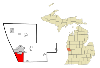
Montague Township is a civil township of Muskegon County in the U.S. state of Michigan. The population was 1,637 at the 2000 census. The city of Montague is located within the township, on the shores of White Lake.

Muskegon Charter Township is a charter township of Muskegon County in the U.S. state of Michigan. The population was 17,737 at the 2000 census. The City of Muskegon is at the southwest corner of the township and is administratively autonomous. The township shares all five of the city's zip codes.

<span class="mw-page-title-main">Muskegon Heights, Michigan</span> City in Michigan, United States

Muskegon Heights is a city in Muskegon County in the U.S. state of Michigan. The population was 9,985 at the 2020 census.

<span class="mw-page-title-main">Norton Shores, Michigan</span> City in Michigan, United States

Norton Shores is a city in Muskegon County in the U.S. state of Michigan. The population was 25,030 at the 2020 census.

<span class="mw-page-title-main">Roosevelt Park, Michigan</span> City in Michigan, United States

Roosevelt Park is a city in Muskegon County in the U.S. state of Michigan. The population was 4,172 at the 2020 census, up from 3,831 in 2010.

<span class="mw-page-title-main">Twin Lake, Michigan</span> Census-designated place & unincorporated community in Michigan, United States

Twin Lake is an unincorporated community in Muskegon County of the U.S. state of Michigan. It is a census-designated place (CDP) for statistical purposes. Local government services are provided by Dalton Township. As of the 2000 census, the community population was 1,613. It is the home of Blue Lake Fine Arts Camp, the YMCA's Camp Pinewood, the Boy Scouts' Gerber Scout Reservation and Owasippe Scout Reservation.

<span class="mw-page-title-main">Wolf Lake, Michigan</span> Census-designated place & unincorporated community in Michigan, United States

Wolf Lake is an unincorporated community and census-designated place (CDP) in Muskegon County in the U.S. state of Michigan. At the 2020 census, the population of Wolf Lake was 5,034. As an unincorporated community, Wolf Lake is governed by Egelston Township. The community lies 4 miles (6.4 km) east of the city of Muskegon.

Spring Lake Township is a civil township of Ottawa County in the U.S. state of Michigan. The population was 13,140 according to the 2000 census and 14,300 according to the 2010 census. The village of Spring Lake is located within the township.

Austin Township is a civil township of Mecosta County in the U.S. state of Michigan. As of the 2020 census, the township population was 1,715.

Blue Lake Township is a civil township of Muskegon County in the U.S. state of Michigan. As of the 2000 census, the township population was 1,990. One of the largest landowners in the township is the Pathway to Adventure Council of the Boy Scouts of America, which owns Owasippe Scout Reservation. The township is also home to the Blue Lake Fine Arts Camp.

References

  1. "2023 U.S. Gazetteer Files: Michigan". United States Census Bureau. Retrieved December 14, 2023.
  2. 1 2 "P1. Race – North Muskegon city, Michigan: 2020 DEC Redistricting Data (PL 94-171)". U.S. Census Bureau. Retrieved December 14, 2023.
  3. 1 2 "U.S. Census website". United States Census Bureau . Retrieved 2008-01-31.
  4. U.S. Geological Survey Geographic Names Information System: North Muskegon, Michigan
  5. "US Gazetteer files 2010". United States Census Bureau. Archived from the original on 2011-02-20. Retrieved 2012-11-25.
  6. "Census of Population and Housing". Census.gov. Retrieved June 4, 2015.
  7. "U.S. Census website". United States Census Bureau . Retrieved 2012-11-25.

43°15′22″N86°16′03″W / 43.25611°N 86.26750°W / 43.25611; -86.26750